


<< Our Photo Pages >> Grimston Church Monolith - Standing Stone (Menhir) in England in Leicestershire and Rutland
Submitted by enkidu41 on Sunday, 15 August 2004 Page Views: 6642
Neolithic and Bronze AgeSite Name: Grimston Church MonolithCountry: England County: Leicestershire and Rutland Type: Standing Stone (Menhir)
Nearest Town: Melton Mowbray Nearest Village: Grimston
Map Ref: SK685219
Latitude: 52.790332N Longitude: 0.985664W
Condition:
| 5 | Perfect |
| 4 | Almost Perfect |
| 3 | Reasonable but with some damage |
| 2 | Ruined but still recognisable as an ancient site |
| 1 | Pretty much destroyed, possibly visible as crop marks |
| 0 | No data. |
| -1 | Completely destroyed |
| 5 | Superb |
| 4 | Good |
| 3 | Ordinary |
| 2 | Not Good |
| 1 | Awful |
| 0 | No data. |
| 5 | Can be driven to, probably with disabled access |
| 4 | Short walk on a footpath |
| 3 | Requiring a bit more of a walk |
| 2 | A long walk |
| 1 | In the middle of nowhere, a nightmare to find |
| 0 | No data. |
| 5 | co-ordinates taken by GPS or official recorded co-ordinates |
| 4 | co-ordinates scaled from a detailed map |
| 3 | co-ordinates scaled from a bad map |
| 2 | co-ordinates of the nearest village |
| 1 | co-ordinates of the nearest town |
| 0 | no data |
Internal Links:
External Links:
")
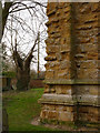
This 5' long millstone grit monolith was found lying 3' down near the base of the church tower during excavations for drainage work in August 1994.
The stone is now in the churchyard.
Description by, and used by kind permission of, Bob Trubshaw, from his Interactive Little-known Leicestershire and Rutland CD-ROM.
You may be viewing yesterday's version of this page. To see the most up to date information please register for a free account.
Do not use the above information on other web sites or publications without permission of the contributor.
Nearby Images from Geograph Britain and Ireland:
©2014(licence)
©2008(licence)
©2018(licence)
©2012(licence)
©2014(licence)
The above images may not be of the site on this page, they are loaded from Geograph.
Please Submit an Image of this site or go out and take one for us!
Click here to see more info for this site
Nearby sites
Key: Red: member's photo, Blue: 3rd party photo, Yellow: other image, Green: no photo - please go there and take one, Grey: site destroyed
Download sites to:
KML (Google Earth)
GPX (GPS waypoints)
CSV (Garmin/Navman)
CSV (Excel)
To unlock full downloads you need to sign up as a Contributory Member. Otherwise downloads are limited to 50 sites.
Turn off the page maps and other distractions
Nearby sites listing. In the following links * = Image available
141m SW 226° Grimston Stone* Standing Stone (Menhir) (SK684218)
2.4km ESE 113° Saxelbye Stone* Standing Stone (Menhir) (SK707210)
3.1km SW 231° Ragdale Stone* Standing Stone (Menhir) (SK661199)
3.7km SE 143° Asfordby Cross* Ancient Cross (SK7078419006)
3.8km SE 143° All Saints (Asfordby)* Ancient Cross (SK7081218939)
4.0km ENE 76° Ab Kettleby* Holy Well or Sacred Spring (SK724229)
4.3km SSE 169° Frisby Cross Ancient Cross (SK6942017659)
4.5km N 7° Woundheal Spring* Holy Well or Sacred Spring (SK690264)
4.7km NE 46° Clawson Hose and Harby Cursus Cursus (SK718252)
4.8km ENE 62° Holwell Mouth* Holy Well or Sacred Spring (SK7269324230)
4.9km SSW 202° Hoby Stone Standing Stone (Menhir) (SK667173)
5.0km SSE 167° Stump Cross (Frisby on the Wreake) Ancient Cross (SK6969917032)
6.4km ENE 61° Hazeltongue Lodge Henge (SK74092509)
6.5km NE 36° Long Clawson Stone* Standing Stone (Menhir) (SK722272)
7.3km N 5° St Luke (Hickling)* Early Christian Sculptured Stone (SK691292)
8.2km SSW 206° Blue Stone (Rearsby)* Natural Stone / Erratic / Other Natural Feature (SK6497414518)
8.2km WNW 281° Wymeswold Stone* Standing Stone (Menhir) (SK604234)
8.7km S 179° The Blue Stone (Gaddesby)* Standing Stone (Menhir) (SK687132)
8.8km SSW 209° Rearsby Timber Circle Timber Circle (SK643142)
9.0km SSE 161° Folville Cross* Ancient Cross (SK715134)
9.8km ESE 121° Burton Lazars Stockwell* Holy Well or Sacred Spring (SK770170)
10.3km SSW 199° Queniborough Stones* Standing Stones (SK653121)
11.5km SSW 199° Mowde Bush Stone* Standing Stone (Menhir) (SK649110)
12.0km SW 222° Cossington Bronze Age Barrows* Barrow Cemetery (SK605129)
12.5km SE 144° Burrough-on-the-hill* Hillfort (SK761119)
View more nearby sites and additional images

")
 We would like to know more about this location. Please feel free to add a brief description and any relevant information in your own language.
 Wir möchten mehr über diese Stätte erfahren. Bitte zögern Sie nicht, eine kurze Beschreibung und relevante Informationen in Deutsch hinzuzufügen.
 Nous aimerions en savoir encore un peu sur les lieux. S'il vous plaît n'hesitez pas à ajouter une courte description et tous les renseignements pertinents dans votre propre langue.
 Quisieramos informarnos un poco más de las lugares. No dude en añadir una breve descripción y otros datos relevantes en su propio idioma.