<< Our Photo Pages >> King's Norton - Holy Well or Sacred Spring in England in Leicestershire and Rutland
Submitted by enkidu41 on Tuesday, 31 August 2004 Page Views: 5300
Springs and Holy WellsSite Name: King's NortonCountry: England
NOTE: This site is 3.87 km away from the location you searched for.
County: Leicestershire and Rutland Type: Holy Well or Sacred Spring
Nearest Town: Leicester Nearest Village: King's Norton
Map Ref: SK6890100495
Latitude: 52.597889N Longitude: 0.984193W
Condition:
| 5 | Perfect |
| 4 | Almost Perfect |
| 3 | Reasonable but with some damage |
| 2 | Ruined but still recognisable as an ancient site |
| 1 | Pretty much destroyed, possibly visible as crop marks |
| 0 | No data. |
| -1 | Completely destroyed |
| 5 | Superb |
| 4 | Good |
| 3 | Ordinary |
| 2 | Not Good |
| 1 | Awful |
| 0 | No data. |
| 5 | Can be driven to, probably with disabled access |
| 4 | Short walk on a footpath |
| 3 | Requiring a bit more of a walk |
| 2 | A long walk |
| 1 | In the middle of nowhere, a nightmare to find |
| 0 | No data. |
| 5 | co-ordinates taken by GPS or official recorded co-ordinates |
| 4 | co-ordinates scaled from a detailed map |
| 3 | co-ordinates scaled from a bad map |
| 2 | co-ordinates of the nearest village |
| 1 | co-ordinates of the nearest town |
| 0 | no data |
Internal Links:
External Links:
I have visited· I would like to visit
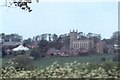
Anne T visited on 24th Jun 2018 - their rating: Cond: 3 Amb: 3 Access: 5 Well, St John The Baptist, King's Norton: This is a very posh village, with very large houses. We parked by the tiny little village green just to the west of the church, almost next to the well, which is low down in the western churchyard wall.
Someone has been refurbishing the well, and recently, as there is a fresh footprint or two in the sand now forming the bottom of the well pool.
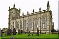
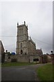
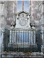
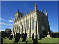
The church is relatively modern, a plaque next to the gate describing it as ‘Georgian Gothic’. The churchyard is relatively small, and not much to see in it, apart from a huge memorial right up against the exterior eastern wall. The church itself was locked, although a name/phone number was given to collect the keys from, but we weren’t interested enough to go inside.
Pastscape describes this well as a ‘horsetrough’. Whilst the well was very dry at the time of our visit, there is no sign within the churchyard (or the neighbouring house) as to where the source of the water comes from, although the top of the ground is at least 2m higher behind the well.
")
This well in the village of King's Norton is in an arched recess in the west wall of the churchyard of St. John the Baptist Church.
Although obviously rebuilt in recent years, the large stone basin (3' deep by 5' wide) still exists. The well appears to be dry as there is no perceptible flow of water from the feed pipe.
Based on the description by, and used by kind permission of, Bob Trubshaw, from his Interactive Little-known Leicestershire and Rutland CD-ROM.
For more information also see Pastscape Monument No. 319275, which includes information about the church itself and describes this feature as a 'horse trough'.
You may be viewing yesterday's version of this page. To see the most up to date information please register for a free account.
")
")
")
")
Do not use the above information on other web sites or publications without permission of the contributor.
Nearby Images from Geograph Britain and Ireland:
©2018(licence)
©2021(licence)
©2021(licence)
©2021(licence)
©2006(licence)
The above images may not be of the site on this page, they are loaded from Geograph.
Please Submit an Image of this site or go out and take one for us!
Click here to see more info for this site
Nearby sites
Key: Red: member's photo, Blue: 3rd party photo, Yellow: other image, Green: no photo - please go there and take one, Grey: site destroyed
Download sites to:
KML (Google Earth)
GPX (GPS waypoints)
CSV (Garmin/Navman)
CSV (Excel)
To unlock full downloads you need to sign up as a Contributory Member. Otherwise downloads are limited to 50 sites.
Turn off the page maps and other distractions
Nearby sites listing. In the following links * = Image available
2.1km SE 125° St Michael's Church (Illston On The Hill)* Ancient Cross (SP7066899287)
3.8km NE 53° Billesdon Cross* Ancient Cross (SK7191302822)
4.3km E 92° St John The Baptist (Rolleston)* Ancient Cross (SK7326200402)
4.9km N 357° Ingarsby* Standing Stone (Menhir) (SK6857805373)
6.1km S 189° The Munt* Artificial Mound (SP6807294487)
6.5km SSE 150° King Charles's Well* Holy Well or Sacred Spring (SP722949)
7.3km SSE 158° St. Ann's Well* Holy Well or Sacred Spring (SP717938)
8.2km NNW 343° Beeby Holy Well* Holy Well or Sacred Spring (SK664083)
8.3km NNW 340° Beeby Henge (SK660083)
9.2km NW 316° The Humber Stone* Standing Stone (Menhir) (SK6241607095)
11.2km NNW 340° Mowde Bush Stone* Standing Stone (Menhir) (SK649110)
11.4km WNW 291° Jewry Wall Museum Museum (SK582045)
11.5km WNW 295° St. Margaret's Church* Holy Well or Sacred Spring (SK584052)
12.1km NNW 344° Queniborough Stones* Standing Stones (SK653121)
12.5km NW 313° St James (Birstall) Early Christian Sculptured Stone (SK59630884)
12.7km N 360° The Blue Stone (Gaddesby)* Standing Stone (Menhir) (SK687132)
12.7km W 267° The Wethers* Standing Stones (SP56149972)
13.2km NNE 12° Folville Cross* Ancient Cross (SK715134)
13.2km SSW 195° Mowsley Stone* Standing Stone (Menhir) (SP657877)
13.5km NNE 33° Burrough-on-the-hill* Hillfort (SK761119)
13.6km W 281° Braunstone Church* Standing Stone (Menhir) (SK555029)
13.8km W 270° Enderby Henge (SK551002)
13.9km WNW 287° Western Park (Leicester)* Misc. Earthwork (SK555043)
14.0km SSE 162° Harborough Museum* Museum (SP7342087285)
14.0km SSE 160° Peter's Pence Stone* Standing Stone (Menhir) (SP740874)
View more nearby sites and additional images


 We would like to know more about this location. Please feel free to add a brief description and any relevant information in your own language.
 Wir möchten mehr über diese Stätte erfahren. Bitte zögern Sie nicht, eine kurze Beschreibung und relevante Informationen in Deutsch hinzuzufügen.
 Nous aimerions en savoir encore un peu sur les lieux. S'il vous plaît n'hesitez pas à ajouter une courte description et tous les renseignements pertinents dans votre propre langue.
 Quisieramos informarnos un poco más de las lugares. No dude en añadir una breve descripción y otros datos relevantes en su propio idioma.