 with our Megalithic Portal iPhone app")
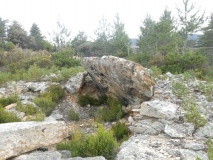

<< Our Photo Pages >> Menhir dit la Chaire au Diable - Standing Stone (Menhir) in France in Pays de la Loire:Mayenne (53)
Submitted by holger_rix on Thursday, 09 June 2016 Page Views: 1060
Neolithic and Bronze AgeSite Name: Menhir dit la Chaire au DiableCountry: France
NOTE: This site is 1.858 km away from the location you searched for.
Département: Pays de la Loire:Mayenne (53) Type: Standing Stone (Menhir)
Nearest Town: Mayenne Nearest Village: Haie-Traversaine
Latitude: 48.339564N Longitude: 0.599914W
Condition:
| 5 | Perfect |
| 4 | Almost Perfect |
| 3 | Reasonable but with some damage |
| 2 | Ruined but still recognisable as an ancient site |
| 1 | Pretty much destroyed, possibly visible as crop marks |
| 0 | No data. |
| -1 | Completely destroyed |
| 5 | Superb |
| 4 | Good |
| 3 | Ordinary |
| 2 | Not Good |
| 1 | Awful |
| 0 | No data. |
| 5 | Can be driven to, probably with disabled access |
| 4 | Short walk on a footpath |
| 3 | Requiring a bit more of a walk |
| 2 | A long walk |
| 1 | In the middle of nowhere, a nightmare to find |
| 0 | No data. |
| 5 | co-ordinates taken by GPS or official recorded co-ordinates |
| 4 | co-ordinates scaled from a detailed map |
| 3 | co-ordinates scaled from a bad map |
| 2 | co-ordinates of the nearest village |
| 1 | co-ordinates of the nearest town |
| 0 | no data |
Internal Links:
External Links:
I have visited· I would like to visit
littleocky visited on 1st Aug 2023 - their rating: Cond: 3 Amb: 5 Access: 3 If you drive from Mayenne towards La Haie-Traversaine towards the bottom of the hill there is a turning on the left marked "Les Canaries" and "La Pillerie". Almost immediately after this is a turning on the right whose sign is overgrown, but this is the road you want. Follow this until you reach a T-junction where you turn right. On the left hand side you will see a small chapel which is where you can park. On the right hand side of the chapel there is a track down to the river. After about 10 minutes you will reach the river where there is a small bridge (much firmer than it looks!) which takes you across a stream to the Chair of the Devil. This is a large lump of stone with some weathering, but which is otherwise in good order. There were no signs or explanatory notes at the site. It is a beautifully scenic position!
")
Haie-Traversaine, Montreuil-Poulay, Mayenne, Pays de la Loire
Source: T4T35
Information and Pictures:
petit-patrimoine
You may be viewing yesterday's version of this page. To see the most up to date information please register for a free account.
Do not use the above information on other web sites or publications without permission of the contributor.
Nearby Images from Flickr


The above images may not be of the site on this page, but were taken nearby. They are loaded from Flickr so please click on them for image credits.
Click here to see more info for this site
Nearby sites
Click here to view sites on an interactive map of the areaKey: Red: member's photo, Blue: 3rd party photo, Yellow: other image, Green: no photo - please go there and take one, Grey: site destroyed
Download sites to:
KML (Google Earth)
GPX (GPS waypoints)
CSV (Garmin/Navman)
CSV (Excel)
To unlock full downloads you need to sign up as a Contributory Member. Otherwise downloads are limited to 50 sites.
Turn off the page maps and other distractions
Nearby sites listing. In the following links * = Image available
3.3km SE 125° Bas Villette Dolmen Burial Chamber or Dolmen
3.5km ESE 119° Allée Couverte de la Petite Giraudière Passage Grave
5.7km SE 146° Aron Stèle Gauloise* Standing Stone (Menhir)
7.3km W 272° Menhir de la Chablère* Standing Stone (Menhir)
7.9km SSW 194° Oppidum de Moulay Ancient Village or Settlement
8.9km ESE 114° Stèles de petite croix* Standing Stones
9.1km NNE 20° La Hamelinière* Passage Grave
9.5km SE 141° La Chaire du Diable Sculptured Stone
9.9km N 6° Grand Coudray Menhir* Standing Stone (Menhir)
10.6km WNW 285° l’Allée couverte de la Gasnerie Passage Grave
10.6km W 266° La Croix de la Fizellerie* Standing Stone (Menhir)
10.7km W 276° Allée Couverte de la Grande-Burlaie Passage Grave
11.0km S 183° Les Chauvières* Standing Stone (Menhir)
11.2km NW 314° Menhir dit la Pierre Saint-Siviard* Standing Stone (Menhir)
11.4km NNE 13° Dolmen de la Guichardière Burial Chamber or Dolmen
11.5km WNW 282° Allée couverte du Rocher Passage Grave
11.6km WNW 282° Menhir de la Chaire* Standing Stone (Menhir)
11.7km NNE 15° Bignon Menhir* Standing Stone (Menhir)
11.7km NNE 16° Bignon Dolmen* Burial Chamber or Dolmen
11.9km WNW 288° Petit-Vieux-Sou* Passage Grave
12.0km WSW 246° Allée couverte de Baillée Passage Grave
12.0km SE 140° Les Fouées* Standing Stone (Menhir)
12.1km SE 141° Jublains museum stone* Standing Stone (Menhir)
12.1km SE 140° Jublains Stèle Gauloise* Standing Stone (Menhir)
12.1km SE 142° Camp Romain de Jublains* Ancient Village or Settlement
View more nearby sites and additional images


 We would like to know more about this location. Please feel free to add a brief description and any relevant information in your own language.
 Wir möchten mehr über diese Stätte erfahren. Bitte zögern Sie nicht, eine kurze Beschreibung und relevante Informationen in Deutsch hinzuzufügen.
 Nous aimerions en savoir encore un peu sur les lieux. S'il vous plaît n'hesitez pas à ajouter une courte description et tous les renseignements pertinents dans votre propre langue.
 Quisieramos informarnos un poco más de las lugares. No dude en añadir una breve descripción y otros datos relevantes en su propio idioma.