


<< Our Photo Pages >> La Croix de la Fizellerie - Standing Stone (Menhir) in France in Pays de la Loire:Mayenne (53)
Submitted by TheCaptain on Wednesday, 28 August 2013 Page Views: 1663
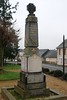
Neolithic and Bronze AgeSite Name: La Croix de la Fizellerie Alternative Name: La stèle gauloise de la Fizellerie, Stèle de Châtillon-sur-ColmontCountry: France Département: Pays de la Loire:Mayenne (53) Type: Standing Stone (Menhir)
Nearest Town: Mayenne Nearest Village: Châtillon-sur-Colmont
Latitude: 48.333600N Longitude: 0.7434W
Condition:
| 5 | Perfect |
| 4 | Almost Perfect |
| 3 | Reasonable but with some damage |
| 2 | Ruined but still recognisable as an ancient site |
| 1 | Pretty much destroyed, possibly visible as crop marks |
| 0 | No data. |
| -1 | Completely destroyed |
| 5 | Superb |
| 4 | Good |
| 3 | Ordinary |
| 2 | Not Good |
| 1 | Awful |
| 0 | No data. |
| 5 | Can be driven to, probably with disabled access |
| 4 | Short walk on a footpath |
| 3 | Requiring a bit more of a walk |
| 2 | A long walk |
| 1 | In the middle of nowhere, a nightmare to find |
| 0 | No data. |
| 5 | co-ordinates taken by GPS or official recorded co-ordinates |
| 4 | co-ordinates scaled from a detailed map |
| 3 | co-ordinates scaled from a bad map |
| 2 | co-ordinates of the nearest village |
| 1 | co-ordinates of the nearest town |
| 0 | no data |
Internal Links:
External Links:
I have visited· I would like to visit
thereddragon visited on 16th Feb 2015 - their rating: Cond: 4 Amb: 3 Access: 5 Was in the area so checked it out.
")
Also known as La stèle gauloise de la Fizellerie or Stèle de Châtillon-sur-Colmont
You may be viewing yesterday's version of this page. To see the most up to date information please register for a free account.
")
")
Do not use the above information on other web sites or publications without permission of the contributor.
Nearby Images from Flickr
The above images may not be of the site on this page, but were taken nearby. They are loaded from Flickr so please click on them for image credits.
Click here to see more info for this site
Nearby sites
Click here to view sites on an interactive map of the areaKey: Red: member's photo, Blue: 3rd party photo, Yellow: other image, Green: no photo - please go there and take one, Grey: site destroyed
Download sites to:
KML (Google Earth)
GPX (GPS waypoints)
CSV (Garmin/Navman)
CSV (Excel)
To unlock full downloads you need to sign up as a Contributory Member. Otherwise downloads are limited to 50 sites.
Turn off the page maps and other distractions
Nearby sites listing. In the following links * = Image available
1.8km N 358° Allée Couverte de la Grande-Burlaie Passage Grave
3.0km NNW 347° Allée couverte du Rocher Passage Grave
3.2km NNW 348° Menhir de la Chaire* Standing Stone (Menhir)
3.4km N 7° l’Allée couverte de la Gasnerie Passage Grave
3.5km ENE 74° Menhir de la Chablère* Standing Stone (Menhir)
4.2km S 185° Allée couverte de Baillée Passage Grave
4.3km N 351° Petit-Vieux-Sou* Passage Grave
6.0km SW 222° Dolmen de la Crête* Passage Grave
7.4km NW 316° Stèle de Brécé B Standing Stone (Menhir)
7.4km NW 316° Stèle de Brécé A Standing Stone (Menhir)
8.8km NNE 16° Menhir dit la Pierre Saint-Siviard* Standing Stone (Menhir)
9.3km NNW 332° Menhir de la Roche (Gorron)* Standing Stone (Menhir)
9.4km N 351° La Pierre Saint-Guillaume Standing Stone (Menhir)
9.7km SW 224° Allée Couverte de la Perche Passage Grave
9.9km SW 236° La Berthellière* Polissoir
10.6km E 86° Menhir dit la Chaire au Diable* Standing Stone (Menhir)
11.1km SE 129° Oppidum de Moulay Ancient Village or Settlement
12.2km N 358° Chataigneraie Menhir* Standing Stone (Menhir)
12.3km NW 317° Dolmen de la Pierre (Hercé)* Burial Chamber or Dolmen
12.6km W 268° La Tardivière* Passage Grave
13.4km E 95° Bas Villette Dolmen Burial Chamber or Dolmen
13.7km E 94° Allée Couverte de la Petite Giraudière Passage Grave
13.8km N 9° Menhir de Moncorbeau* Standing Stone (Menhir)
14.2km W 267° La Contrie du Rocher* Burial Chamber or Dolmen
14.4km W 264° Menhir de la Blanchardière Standing Stone (Menhir)
View more nearby sites and additional images


 We would like to know more about this location. Please feel free to add a brief description and any relevant information in your own language.
 Wir möchten mehr über diese Stätte erfahren. Bitte zögern Sie nicht, eine kurze Beschreibung und relevante Informationen in Deutsch hinzuzufügen.
 Nous aimerions en savoir encore un peu sur les lieux. S'il vous plaît n'hesitez pas à ajouter une courte description et tous les renseignements pertinents dans votre propre langue.
 Quisieramos informarnos un poco más de las lugares. No dude en añadir una breve descripción y otros datos relevantes en su propio idioma.