<< Our Photo Pages >> Artington Spring - Holy Well or Sacred Spring in England in Surrey
Submitted by DavidCWoods on Sunday, 16 January 2005 Page Views: 14714
Springs and Holy WellsSite Name: Artington SpringCountry: England
NOTE: This site is 0.245 km away from the location you searched for.
County: Surrey Type: Holy Well or Sacred Spring
Nearest Town: Guildford Nearest Village: Artington
Map Ref: SU994482
Latitude: 51.224349N Longitude: 0.577949W
Condition:
| 5 | Perfect |
| 4 | Almost Perfect |
| 3 | Reasonable but with some damage |
| 2 | Ruined but still recognisable as an ancient site |
| 1 | Pretty much destroyed, possibly visible as crop marks |
| 0 | No data. |
| -1 | Completely destroyed |
| 5 | Superb |
| 4 | Good |
| 3 | Ordinary |
| 2 | Not Good |
| 1 | Awful |
| 0 | No data. |
| 5 | Can be driven to, probably with disabled access |
| 4 | Short walk on a footpath |
| 3 | Requiring a bit more of a walk |
| 2 | A long walk |
| 1 | In the middle of nowhere, a nightmare to find |
| 0 | No data. |
| 5 | co-ordinates taken by GPS or official recorded co-ordinates |
| 4 | co-ordinates scaled from a detailed map |
| 3 | co-ordinates scaled from a bad map |
| 2 | co-ordinates of the nearest village |
| 1 | co-ordinates of the nearest town |
| 0 | no data |
Internal Links:
External Links:
I have visited· I would like to visit
Lana would like to visit
Ogham visited on 6th Jan 2010 - their rating: Cond: 3 Amb: 4 Access: 4
")
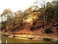
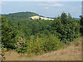
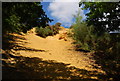
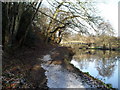
I visited the site in January 2005. It is at the base of St. Catherine’s Hill (formally Drake’s Hill), itself surmounted by the remains of St. Catherine’s chapel. Having parked by the entrance to the lane named St. Catherine’s Hill I followed the road downhill; it becomes a footpath, heading down to the site of the old ferry. The spring is by the side of the road, with a copious outflow of water flowing down to the River Wey. The water emerges from an opening in the hill framed by a dry stone surround. There are remnants of some more masonry are at the bottom of the stream, which flows under an ornamental bridge and beside a seat on its way to the river.
You may be viewing yesterday's version of this page. To see the most up to date information please register for a free account.
")
Do not use the above information on other web sites or publications without permission of the contributor.
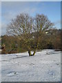
Nearby Images from Geograph Britain and Ireland:
©2006(licence)
©2013(licence)
©2010(licence)
©2009(licence)
©2009(licence)
The above images may not be of the site on this page, they are loaded from Geograph.
Please Submit an Image of this site or go out and take one for us!
Click here to see more info for this site
Nearby sites
Key: Red: member's photo, Blue: 3rd party photo, Yellow: other image, Green: no photo - please go there and take one, Grey: site destroyed
Download sites to:
KML (Google Earth)
GPX (GPS waypoints)
CSV (Garmin/Navman)
CSV (Excel)
To unlock full downloads you need to sign up as a Contributory Member. Otherwise downloads are limited to 50 sites.
Turn off the page maps and other distractions
Nearby sites listing. In the following links * = Image available
894m NNW 335° St. Edward's Well* Holy Well or Sacred Spring (SU9949)
1.1km NNE 16° Guildford Museum* Museum (SU9968349258)
2.7km E 83° Tyting Farm Bowl Barrow* Round Barrow(s) (TQ02124857)
3.3km E 91° St Martha's on the Hill Earth Circles* Misc. Earthwork (TQ027482)
4.1km E 92° Lid Well* Holy Well or Sacred Spring (TQ03554815)
5.4km N 3° Whitmoor Common* Round Barrow(s) (SU996536)
5.7km N 11° Jacobs Well* Holy Well or Sacred Spring (TQ004538)
5.9km E 93° Albury Fishponds* Natural Stone / Erratic / Other Natural Feature (TQ053480)
6.1km E 89° Weston Wood Platform Mound* Round Barrow(s) (TQ055484)
6.2km E 89° Weston Woods Cromlech* Standing Stones (TQ05644839)
6.6km SSW 204° Lady Well (Tuesley)* Holy Well or Sacred Spring (SU968421)
6.7km E 88° The Silent Pool* Holy Well or Sacred Spring (TQ0606148582)
6.8km E 98° Albury Park Mound* Round Barrow(s) (TQ062474)
8.4km W 262° Hillbury hillfort* Hillfort (SU911468)
8.5km NNW 329° Bullswater Common Barrows Barrow Cemetery (SU9487555356)
9.6km S 175° Hascombe Hill* Hillfort (TQ004386)
9.8km S 171° The Dragonstones Modern Stone Circle etc (TQ0105038489)
10.5km WSW 257° Culverswell Barrow* Round Barrow(s) (SU892456)
10.6km WSW 253° Crooksbury Common Barrows* Barrow Cemetery (SU893450)
11.2km WSW 251° Tilford Barrows Barrow Cemetery (SU889443)
11.4km N 358° Horsell Birch Natural Stone / Erratic / Other Natural Feature (SU98805956)
11.5km NNE 24° Pyrford Stone* Marker Stone (TQ0382258782)
11.5km W 261° Soldier's Ring* Hillfort (SU880462)
11.8km N 11° Horsell Common W* Barrow Cemetery (TQ01405980)
11.8km NNE 12° Horsell Common E* Round Barrow(s) (TQ01615977)
View more nearby sites and additional images


 We would like to know more about this location. Please feel free to add a brief description and any relevant information in your own language.
 Wir möchten mehr über diese Stätte erfahren. Bitte zögern Sie nicht, eine kurze Beschreibung und relevante Informationen in Deutsch hinzuzufügen.
 Nous aimerions en savoir encore un peu sur les lieux. S'il vous plaît n'hesitez pas à ajouter une courte description et tous les renseignements pertinents dans votre propre langue.
 Quisieramos informarnos un poco más de las lugares. No dude en añadir una breve descripción y otros datos relevantes en su propio idioma.