Featured: Explore Scotland (and everywhere else) with our Megalithic Portal iPhone app

Explore Scotland (and everywhere else) with our Megalithic Portal iPhone app

Random Image


Madera Caves

Solving Stonehenge, the new key to an ancient enigma

Solving Stonehenge, the new key to an ancient enigma

Who's Online

There are currently, 243 guests and 1 members online.

You are a guest. To join in, please register for free by clicking here

Sponsors

<< Our Photo Pages >> Albury Fishponds - Natural Stone / Erratic / Other Natural Feature in England in Surrey

Submitted by Andy B on Wednesday, 17 February 2021  Page Views: 10492

Natural PlacesSite Name: Albury Fishponds
Country: England County: Surrey Type: Natural Stone / Erratic / Other Natural Feature
Nearest Town: Guildford  Nearest Village: Albury
Map Ref: TQ053480
Latitude: 51.221494N  Longitude: 0.493549W
Condition:
5Perfect
4Almost Perfect
3Reasonable but with some damage
2Ruined but still recognisable as an ancient site
1Pretty much destroyed, possibly visible as crop marks
0No data.
-1Completely destroyed
Destroyed Ambience:
5Superb
4Good
3Ordinary
2Not Good
1Awful
0No data.
3 Access:
5Can be driven to, probably with disabled access
4Short walk on a footpath
3Requiring a bit more of a walk
2A long walk
1In the middle of nowhere, a nightmare to find
0No data.
4 Accuracy:
5co-ordinates taken by GPS or official recorded co-ordinates
4co-ordinates scaled from a detailed map
3co-ordinates scaled from a bad map
2co-ordinates of the nearest village
1co-ordinates of the nearest town
0no data
3

Internal Links:
External Links:

Albury Fishponds
Albury Fishponds submitted by Andy B : This impressive 200mm long Neolithic axe was discovered in the 1990s, when the smaller western Weston Fishery lake in Albury was being dredged. Photo contributed to the Albury History Society by local photographer John Powell, whose son found it. With thanks to Trevor Brook for the upload. (Vote or comment on this photo)
The village of Albury in Surrey is rumoured to have been the location of a cromlech, and was certainly home to other prehistoric finds including barrows and a Mesolithic or possibly Neolithic house in the nearby quarry. See the nearby sites list from this page for more potential sites.

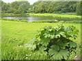
There was a fair sized monolith lying by the side of the car park in between the two lakes of Albury Fishery. Eileen Roche has scoured the surrounding are over many years searching for traces of the stone circle mentioned in Albury. This was the only sizeable stone in the area and could have been a potential candidate but see the comments below. It seems this stone at the fishponds was a red herring (groan!)

What we do know is that a mesolithic house (previously known as a 'pit dwelling') was excavated in Weston Wood to the north. More recent references think this may be neolithic. A number of stone tools were found by J.M.Harding. The grid reference given for these finds is TQ050485, which puts them to the north of (or possibly obliterated by) the large sand extractions at the top of the hill.

The book Three Surrey Churches - A Chapter of English History (by Rev H R Ware & P G Palmer, undated but from circa 1910) has a chapter on St Martha's including the following tantalising references.

"To the east of the hill, on the rising ground of Weston Wood, towards Sherborne Springs, lie huge boulders, foreign to this part of England, relics of a cromlech. Similar remains once existed near Albury Rectory, and a mass of rock in Colyer's Hanger, on the hillside, probably marks the site of a third."

With thanks to Eileen Roche for uncovering this stone.

Note: This impressive 200mm long Neolithic axe was discovered in the 1990s, when the smaller western Weston Fishery lake in Albury was being dredged. With thanks to Trevor Brook from the Albury History Society, who has also found an intriguing map of stones around the Weston Woods area of Albury, drawn by a local surveyor in 1975.
You may be viewing yesterday's version of this page. To see the most up to date information please register for a free account.


Albury Fishponds
Albury Fishponds submitted by takstone : Large stone no longer present on Albury fishing lakes 30 March 2021 (2) (Vote or comment on this photo)

Albury Fishponds
Albury Fishponds submitted by takstone : Large stone no longer present on Albury fishing lakes 30 March 2021 (1) (Vote or comment on this photo)

Albury Fishponds
Albury Fishponds submitted by Andy B : The enigmatic stone in Jan 2005, becoming lost again. (Vote or comment on this photo)

Albury Fishponds
Albury Fishponds submitted by Eileen : The Albury Stone in 1998 - the only result of a meticulous search for the missing megaliths described in the pamphlet, "Three Surrey Churches". (1 comment - Vote or comment on this photo)

Do not use the above information on other web sites or publications without permission of the contributor.

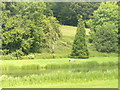
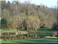
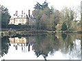
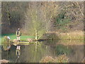
Nearby Images from Geograph Britain and Ireland:
TQ0547 : Weston Fishery by Colin Smith
by Colin Smith
©2011(licence)
TQ0547 : Weston Fishery by Colin Smith
by Colin Smith
©2008(licence)
TQ0547 : Reflections of Albury by Colin Smith
by Colin Smith
©2008(licence)
TQ0547 : Fly Fishing, Albury by Colin Smith
by Colin Smith
©2008(licence)
TQ0547 : Weston Fishery, Albury by Colin Smith
by Colin Smith
©2011(licence)

The above images may not be of the site on this page, they are loaded from Geograph.
Please Submit an Image of this site or go out and take one for us!


Click here to see more info for this site

Nearby sites

Click here to view sites on an interactive OS map

Key: Red: member's photo, Blue: 3rd party photo, Yellow: other image, Green: no photo - please go there and take one, Grey: site destroyed

Download sites to:
KML (Google Earth)
GPX (GPS waypoints)
CSV (Garmin/Navman)
CSV (Excel)

To unlock full downloads you need to sign up as a Contributory Member. Otherwise downloads are limited to 50 sites.


Turn off the page maps and other distractions

Nearby sites listing. In the following links * = Image available
 447m NNE 28° Weston Wood Platform Mound* Round Barrow(s) (TQ055484)
 517m NE 42° Weston Woods Cromlech* Standing Stones (TQ05644839)
 956m NE 54° The Silent Pool* Holy Well or Sacred Spring (TQ0606148582)
 1.1km SE 125° Albury Park Mound* Round Barrow(s) (TQ062474)
 1.8km W 276° Lid Well* Holy Well or Sacred Spring (TQ03554815)
 2.6km W 276° St Martha's on the Hill Earth Circles* Misc. Earthwork (TQ027482)
 3.2km WNW 281° Tyting Farm Bowl Barrow* Round Barrow(s) (TQ02124857)
 5.7km WNW 284° Guildford Museum* Museum (SU9968349258)
 5.9km W 273° Artington Spring* Holy Well or Sacred Spring (SU994482)
 6.3km ESE 112° Abinger Manor* Ancient Village or Settlement (TQ112458)
 6.4km W 280° St. Edward's Well* Holy Well or Sacred Spring (SU9949)
 6.4km ESE 122° Felday* Hillfort (TQ10824475)
 6.5km E 91° Deerleap Wood* Round Barrow(s) (TQ118480)
 7.2km SE 135° Holmbury Camp Hillfort (TQ105430)
 7.6km NW 321° Jacobs Well* Holy Well or Sacred Spring (TQ004538)
 8.0km NW 316° Whitmoor Common* Round Barrow(s) (SU996536)
 9.5km ESE 106° Mag's Well (Abinger Forest)* Holy Well or Sacred Spring (TQ145455)
 9.7km SE 127° Leith Hill Place* Natural Stone / Erratic / Other Natural Feature (TQ1324542344)
 10.0km E 86° Milton Heath* Round Barrow(s) (TQ15294890)
 10.3km WSW 236° Lady Well (Tuesley)* Holy Well or Sacred Spring (SU968421)
 10.4km SSW 205° The Dragonstones Modern Stone Circle etc (TQ0105038489)
 10.6km SSW 209° Hascombe Hill* Hillfort (TQ004386)
 10.8km ESE 113° Anstiebury Camp* Hillfort (TQ1534244008)
 10.9km N 353° Pyrford Stone* Marker Stone (TQ0382258782)
 11.3km NNE 13° Bowl barrow west of Cockcrow Hill* Round Barrow(s) (TQ07635910)
View more nearby sites and additional images

<< Hügelgrab Petznick 22405

Ffynnon Gadferth Medieval Holy Well >>

Please add your thoughts on this site

Cures and Curses, Ritual and cult at holy wells

Cures and Curses, Ritual and cult at holy wells

Sponsors

Auto-Translation (Google)

Translate from English into:

"Albury Fishponds" | Login/Create an Account | 8 News and Comments
  
Go back to top of page    Comments are owned by the poster. We aren't responsible for their content.
Re: Albury Fishponds by takstone on Saturday, 01 May 2021
(User Info | Send a Message)
An update on the large stone that was lying on the dam between the Albury lakes, as shown in the 1998 photo on this page.
I visited this site one month ago to see if the stone was still around. No sign of it (see two photos). That patch of ground on the dam, which is easy to locate very precisely, is now overgrown with brambles and prodding around did not reveal a stone there. I next enquired at the nearby office of the Albury Estate, owner the fishing lakes, which were created in the early 1980s. In a more recent project to build a fishing lodge at the eastern end of the upper lake, stones steps were created down to the lake and it is believed the ‘megalith’ was moved and used as part of this exercise. Having read the post from tonyh27 dated 2008 about the stone materials used to build the nearby waterfall (overspill) between the lakes, I also asked the estate office about the origin of the stone. The surprising answer was that the builder of the lakes had purchased the stones from near Heathrow Airport as a job lot from a farmer – and that the stones had come from the demolition of the original Waterloo Bridge in the 1930s.
Finding this intriguing, I did some further research. The first Waterloo Bridge (originally opened in 1817) was built of granite. But that doesn’t fit the ‘soft stone’ description from the 2008 posting? Further research showed that the bridge had been clad in granite but had a sandstone structure – much more like the colour of the stone on the dam taken in 1998, shown above. I also found old adverts for the Waterloo Bridge stones being sold in the Hounslow area. So there seemed to be a glimmer of truth in the tale that the stone had come from Waterloo Bridge.
To get confirmation of this, I found out which local company had built the Albury lakes and dam in the 1980s (now a large corporation) and wrote to the chairman, who in the early days as founder of the company had been the man that bought the stone for the project. He replied this morning by letter confirming that he had purchased the stone as a job lot from a pig farm (where Terminal 5 now stands). It was indeed the stone from Waterloo Bridge which had originally been shipped by sea from Cornwall – both the granite and the sandstone.
I think that closes the circle on the mysterious Albury megalith. It was probably Cornish sandstone, shaped by men building the first Waterloo Bridge, and not part of any ancient monument in the Surrey area.
[ Reply to This ]
    Re: Albury Fishponds by Andy B on Saturday, 01 May 2021
    (User Info | Send a Message)
    Hello Takstone
    Amazing research, many thanks for posting that.
    Ruling out this stone is really useful but only part of the story.

    The other new piece of information is the map here found by Trevor
    https://www.megalithic.co.uk/modules.php?op=modload&name=a312&file=index&do=showpic&pid=223317

    I am giving a talk to Albury History Society on Tuesday 18 May which will include a summary of what we know on this - which isn't much but it should help keep the interest going in this. If anyone else is interested in researching this please get in touch.

    Thanks
    Andy
    [ Reply to This ]
      Re: Albury Fishponds by takstone on Saturday, 01 May 2021
      (User Info | Send a Message)
      Hello Andy.
      I had come across that map when I did my recent research – the map and the comments from the Albury History Society added to my interest in the ‘megalith on the dam’. I took a hike through Colyers Hanger (referred to by you in your quote from the Three Surrey Churches book), which lies just to the west of the area shown on the map. I hoped I might come across a stone or two, but no luck. A very wooded and hilly area.

      I would like to be at your talk on 18 May but I am already committed to be elsewhere that day.
      [ Reply to This ]

Re: Albury Fishponds by Blingo_von_Trumpenstein on Friday, 19 February 2021
(User Info | Send a Message)
My favourite type of flint axe - the two-sided pointbutted variety. Beautiful patination and a good polish. Can be no younger than 5500yo and probably more like 6000yo. In my experience, there are 20 thinbutted axes for every 1 pointbutted axe.
[ Reply to This ]

Prehistoric Albury by Andy B on Wednesday, 06 January 2021
(User Info | Send a Message)
Trevor Brook from Albury History Society writes: A load of paperwork from the late Caroline Martin has come our way and I've been busy adding scans to the website. This one has references to old settlements:
http://alburyhistory.org.uk/attachments/File/Albury%20notes%20Caroline%20Martin.pdf
search the text for stones or bronze.

Also this booklet published in 1950: Walks around Albury, Surrey by O.M. Heath
http://alburyhistory.org.uk/attachments/File/Walks%20Round%20Albury%20by%20O.M.%20Heath.pdf
describes a cromlech and droves of 500 Welsh cattle on page 4 of the book: "A cromlech which stood near Sherborne [the ancient name for the Silent Pool] is said to have once been the the site of the Sherborne fair"
[ Reply to This ]

Undiscovered long barrow somewhere along the North downs by Andy B on Tuesday, 21 July 2015
(User Info | Send a Message)
I agree this stone is a bit of a long shot but we are convinced there is a lost stone monument somewhere in the Albury area.

Looking at the distribution of other long barrows it would be completely logical location wise for there to be an undiscovered long barrow somewhere along the North downs.

By rights there should be at least one other barrow between Badsot Lea and the Kent group of Coldrum etc

A good start would be to get hold of the LIDAR data for the area and do some analysis.
It's available free for non-commercial / academic use.
[ Reply to This ]

Re: Albury Fishponds by tonyh27 on Tuesday, 06 May 2008
(User Info | Send a Message)
I have checked out that Stone...

It is laying on the dam between the higher and lower lake. The dam is clearly man made and does not appear to have much age to it..

The stone is made of very soft chalk - it scratches very easily. There is a waterfall feeding the lower lake (From the top) only a few yards from the stone.. This waterfall is also man made and without any great age...

The slabs of stone used to construct the waterfall are approximately the same size as the stone laying in the car park and would seem to be of the same material..
[ Reply to This ]

Your Name: Anonymous [ Register Now ]
Subject:


Add your comment or contribution to this page. Spam or offensive posts are deleted immediately, don't even bother

<<< What is five plus one as a number? (Please type the answer to this question in the little box on the left)
You can also embed videos and other things. For Youtube please copy and paste the 'embed code'.
For Google Street View please include Street View in the text.
Create a web link like this: <a href="https://www.megalithic.co.uk">This is a link</a>  

Allowed HTML is:
<p> <b> <i> <a> <img> <em> <br> <strong> <blockquote> <tt> <li> <ol> <ul> <object> <param> <embed> <iframe>

We would like to know more about this location. Please feel free to add a brief description and any relevant information in your own language.
Wir möchten mehr über diese Stätte erfahren. Bitte zögern Sie nicht, eine kurze Beschreibung und relevante Informationen in Deutsch hinzuzufügen.
Nous aimerions en savoir encore un peu sur les lieux. S'il vous plaît n'hesitez pas à ajouter une courte description et tous les renseignements pertinents dans votre propre langue.
Quisieramos informarnos un poco más de las lugares. No dude en añadir una breve descripción y otros datos relevantes en su propio idioma.