<< Our Photo Pages >> Cloutie Well - Holy Well or Sacred Spring in Scotland in Highlands
Submitted by livingstone on Monday, 31 January 2022 Page Views: 17675
Springs and Holy WellsSite Name: Cloutie Well Alternative Name: St Curitan's WellCountry: Scotland County: Highlands Type: Holy Well or Sacred Spring
Nearest Village: Munlochy
Map Ref: NH641537 Landranger Map Number: 26
Latitude: 57.552911N Longitude: 4.272742W
Condition:
| 5 | Perfect |
| 4 | Almost Perfect |
| 3 | Reasonable but with some damage |
| 2 | Ruined but still recognisable as an ancient site |
| 1 | Pretty much destroyed, possibly visible as crop marks |
| 0 | No data. |
| -1 | Completely destroyed |
| 5 | Superb |
| 4 | Good |
| 3 | Ordinary |
| 2 | Not Good |
| 1 | Awful |
| 0 | No data. |
| 5 | Can be driven to, probably with disabled access |
| 4 | Short walk on a footpath |
| 3 | Requiring a bit more of a walk |
| 2 | A long walk |
| 1 | In the middle of nowhere, a nightmare to find |
| 0 | No data. |
| 5 | co-ordinates taken by GPS or official recorded co-ordinates |
| 4 | co-ordinates scaled from a detailed map |
| 3 | co-ordinates scaled from a bad map |
| 2 | co-ordinates of the nearest village |
| 1 | co-ordinates of the nearest town |
| 0 | no data |
Internal Links:
External Links:
I have visited· I would like to visit
PrincessOfAvalon visited on 21st Sep 2017 - their rating: Cond: 3 Amb: 2 Access: 4 The well is positioned near the top of a high ridge which is unusual, so I could see why Otis special. Take the path from the north side of the car park, and go left at the first Y.
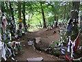
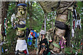
The spring was not running when I visited. A lot of the clooties that were left are unfortunately of synthetic material and will not degrade as they are intended to. As a result the area looks a bit trashy.
The name of the site as indicated n the road sign is "Clootie Well".
LenGilbert visited on 30th Jul 2015 - their rating: Cond: 3 Amb: 5 Access: 5 Very easy to visit, well signed from the roadway. There is a parking area and several paths. I recommend going left and coming into the well counterclockwise. There is a wide range of cloth tied to the trees and if you are attentive, they can tell a bit of a story. There are also coins in the area where the well spills over.
I was there with only a couple who didn't stay long, so I was able to enjoy the well.
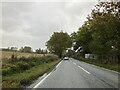
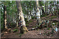
livingstone visited on 8th Jan 2011 - their rating: Cond: 4 Amb: 5 Access: 3 As Cloutie wells go this one is superb. Easily seen from the roadside it is a major tourist attraction. Sadly some people ignore advice to NOT leave nylon or other non-degradable materials and so the site has become a bit of an eyesore. It is though a fascinating place to visit and has a definate ambience. The spring runs into a cistern and away under the road. Getting close to the wellhead would be extremly difficult for disabled persons.
Average ratings for this site from all visit loggers: Condition: 3.33 Ambience: 4 Access: 4
")
Getting close to the wellhead would be extremely difficult for disabled persons.
PrincessOfAvalon visited on 21st Sep 2017: Condition: 3 Ambience: 2 Access: 4 The well is positioned near the top of a high ridge which is unusual, so I could see why Otis special. Take the path from the north side of the car park, and go left at the first Y. The spring was not running when I visited. A lot of the clooties that were left are unfortunately of synthetic material and will not degrade as they are intended to. As a result the area looks a bit trashy. The name of the site as indicated on the road sign is "Clootie Well".
LenGilbert visited on 30th Jul 2015: Condition: 3 Ambience: 5 Access: 5 Very easy to visit, well signed from the roadway. There is a parking area and several paths. I recommend going left and coming into the well counterclockwise. There is a wide range of cloth tied to the trees and if you are attentive, they can tell a bit of a story. There are also coins in the area where the well spills over. I was there with only a couple who didn't stay long, so I was able to enjoy the well.
Page originally by Vicky
Note: Local uproar as this this ancient Black Isle site has recently been cleaned up by a mystery person, although others accept it was a bit of a mess! We hope that better management will come out of this. More in the comments on our page
You may be viewing yesterday's version of this page. To see the most up to date information please register for a free account.
")
")
Do not use the above information on other web sites or publications without permission of the contributor.
Nearby Images from Geograph Britain and Ireland:
©2007(licence)
©2022(licence)

©2011(licence)
©2021(licence)
©2021(licence)
The above images may not be of the site on this page, they are loaded from Geograph.
Please Submit an Image of this site or go out and take one for us!
Click here to see more info for this site
Nearby sites
Key: Red: member's photo, Blue: 3rd party photo, Yellow: other image, Green: no photo - please go there and take one, Grey: site destroyed
Download sites to:
KML (Google Earth)
GPX (GPS waypoints)
CSV (Garmin/Navman)
CSV (Excel)
To unlock full downloads you need to sign up as a Contributory Member. Otherwise downloads are limited to 50 sites.
Turn off the page maps and other distractions
Nearby sites listing. In the following links * = Image available
1.6km NW 307° Balnaguie* Chambered Cairn (NH62835473)
2.3km N 7° Belmaduthy* Chambered Cairn (NH6447255983)
2.5km WSW 243° The Temple (Tore)* Chambered Tomb (NH6179952610)
3.8km E 96° Craiguck Well* Holy Well or Sacred Spring (NH679532)
6.5km WSW 253° Carn Glas* Chambered Cairn (NH578520)
6.6km WSW 252° Mains of Kilcoy SE* Cairn (NH57765186)
6.6km WSW 252° Mains of Kilcoy NW* Cairn (NH57725191)
7.1km N 8° Woodhead Long* Chambered Cairn (NH653607)
7.1km WNW 294° Mulchaich* Cairn (NH57665679)
7.3km N 5° Woodhead Round Chambered Cairn* Chambered Cairn (NH650610)
7.4km WSW 252° Kilcoy North Chambered Tomb (NH570517)
7.4km WSW 251° Kilcoy South* Chambered Tomb (NH570515)
7.5km WSW 257° Carn Urnan* Stone Circle (NH5666252289)
7.8km N 9° Wester Brae* Chambered Cairn (NH65646139)
8.2km W 260° Cairnside Chambered Tomb (NH560525)
8.5km S 179° Craig Phadraig* Vitrified Fort (NH640452)
8.5km ENE 69° St Boniface's Well (Fortrose)* Holy Well or Sacred Spring (NH722565)
8.8km N 1° St Martin's Well (Fortrose)* Holy Well or Sacred Spring (NH645625)
8.9km SSE 161° Clach-na-Crudainn* Standing Stone (Menhir) (NH66684521)
8.9km SSE 161° Inverness Museum* Museum (NH66684519)
9.1km SSE 165° Knocknagael* Class I Pictish Symbol Stone (NH662448)
9.1km W 261° Muir of Allangrange* Chambered Cairn (NH55005259)
9.3km N 10° Mid Brae Chambered Cairn (NH661628)
9.3km SSE 159° Broad Stone Early Christian Sculptured Stone (NH672449)
9.5km SE 134° Milton Stone Row Stone Row / Alignment (NH70704690)
View more nearby sites and additional images


 We would like to know more about this location. Please feel free to add a brief description and any relevant information in your own language.
 Wir möchten mehr über diese Stätte erfahren. Bitte zögern Sie nicht, eine kurze Beschreibung und relevante Informationen in Deutsch hinzuzufügen.
 Nous aimerions en savoir encore un peu sur les lieux. S'il vous plaît n'hesitez pas à ajouter une courte description et tous les renseignements pertinents dans votre propre langue.
 Quisieramos informarnos un poco más de las lugares. No dude en añadir una breve descripción y otros datos relevantes en su propio idioma.