<< Our Photo Pages >> Inverness Museum - Museum in Scotland in Highlands
Submitted by alligator on Wednesday, 25 February 2004 Page Views: 6757
MuseumsSite Name: Inverness MuseumCountry: Scotland County: Highlands Type: Museum
Nearest Town: Inverness
Map Ref: NH66684519 Landranger Map Number: 26
Latitude: 57.477296N Longitude: 4.225006W
Condition:
| 5 | Perfect |
| 4 | Almost Perfect |
| 3 | Reasonable but with some damage |
| 2 | Ruined but still recognisable as an ancient site |
| 1 | Pretty much destroyed, possibly visible as crop marks |
| 0 | No data. |
| -1 | Completely destroyed |
| 5 | Superb |
| 4 | Good |
| 3 | Ordinary |
| 2 | Not Good |
| 1 | Awful |
| 0 | No data. |
| 5 | Can be driven to, probably with disabled access |
| 4 | Short walk on a footpath |
| 3 | Requiring a bit more of a walk |
| 2 | A long walk |
| 1 | In the middle of nowhere, a nightmare to find |
| 0 | No data. |
| 5 | co-ordinates taken by GPS or official recorded co-ordinates |
| 4 | co-ordinates scaled from a detailed map |
| 3 | co-ordinates scaled from a bad map |
| 2 | co-ordinates of the nearest village |
| 1 | co-ordinates of the nearest town |
| 0 | no data |
Internal Links:
External Links:
I have visited· I would like to visit
hallsifer visited on 3rd Dec 2024 - their rating: Amb: 4 Access: 5 Lovely museum brimming with local history - thoroughly recommend for an overview of ancient sites & artefacts. The pictish carvings on display are fantastic.
coldrum visited - their rating: Cond: 5 Amb: 4 Access: 5
Average ratings for this site from all visit loggers: Ambience: 4 Access: 5
")
Collection of Pictish Symbol Stones
Address: Castle Wynd, Inverness, IV2 3EB
Phone: 01463 237114
Opening Hours: Monday - Saturday 9.00am-5.00pm
Admission: Free
Visit their web site
You may be viewing yesterday's version of this page. To see the most up to date information please register for a free account.
")
Do not use the above information on other web sites or publications without permission of the contributor.
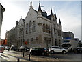
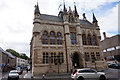
Nearby Images from Geograph Britain and Ireland:
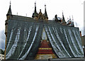
©2015(licence)
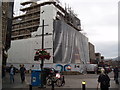
©2017(licence)

©2017(licence)
©2017(licence)
©2018(licence)
The above images may not be of the site on this page, they are loaded from Geograph.
Please Submit an Image of this site or go out and take one for us!
Click here to see more info for this site
Nearby sites
Key: Red: member's photo, Blue: 3rd party photo, Yellow: other image, Green: no photo - please go there and take one, Grey: site destroyed
Download sites to:
KML (Google Earth)
GPX (GPS waypoints)
CSV (Garmin/Navman)
CSV (Excel)
To unlock full downloads you need to sign up as a Contributory Member. Otherwise downloads are limited to 50 sites.
Turn off the page maps and other distractions
Nearby sites listing. In the following links * = Image available
20m N 358° Clach-na-Crudainn* Standing Stone (Menhir) (NH66684521)
594m ESE 117° Broad Stone Early Christian Sculptured Stone (NH672449)
617m SW 229° Knocknagael* Class I Pictish Symbol Stone (NH662448)
2.1km E 91° Raigmore* Clava Cairn (NH6878445083)
2.4km E 88° Beechwood Farm Site Ancient Mine, Quarry or other Industry (NH6908045190)
2.4km ESE 103° Essich House Class I Pictish Symbol Stone (NH69004456)
2.7km W 268° Craig Phadraig* Vitrified Fort (NH640452)
3.5km S 186° Culduthel Clava Cairn* Clava Cairn (NH66194176)
3.7km SSE 148° Druidtemple* Stone Circle (NH685420)
3.8km WSW 253° Leachkin* Chambered Cairn (NH62964416)
4.4km ENE 65° Milton Stone Row Stone Row / Alignment (NH70704690)
4.8km WSW 245° Ladystone Farm* Stone Row / Alignment (NH62204330)
5.3km SSW 204° Torbreck* Stone Circle (NH64384039)
5.5km ENE 62° Allanfearn* Chambered Cairn (NH7163147608)
5.6km E 87° St Mary's Well (Culloden)* Holy Well or Sacred Spring (NH723453)
6.3km ENE 65° Cullearnie* Stone Circle (NH72504768)
7.1km ESE 110° Forrest Cottage* Cairn (NH733426)
7.1km SSW 193° Essich Moor* Chambered Cairn (NH649383)
7.3km ESE 122° Daviot Ring Cairn* Stone Circle (NH727411)
7.6km E 96° Culchunaig* Stone Circle (NH74194416)
7.6km ENE 62° Newton Of Petty* Ring Cairn (NH73484858)
7.6km E 90° The Well of The Dead* Holy Well or Sacred Spring (NH7431844971)
7.6km E 94° Leanach SW* Stone Circle (NH743444)
7.7km E 94° Leanach NE* Chambered Cairn (NH74344444)
7.7km SW 214° Kinchyle Of Dores* Stone Circle (NH62153898)
View more nearby sites and additional images


 We would like to know more about this location. Please feel free to add a brief description and any relevant information in your own language.
 Wir möchten mehr über diese Stätte erfahren. Bitte zögern Sie nicht, eine kurze Beschreibung und relevante Informationen in Deutsch hinzuzufügen.
 Nous aimerions en savoir encore un peu sur les lieux. S'il vous plaît n'hesitez pas à ajouter une courte description et tous les renseignements pertinents dans votre propre langue.
 Quisieramos informarnos un poco más de las lugares. No dude en añadir una breve descripción y otros datos relevantes en su propio idioma.