<< Our Photo Pages >> Moffat Well - Holy Well or Sacred Spring in Scotland in Dumfries and Galloway
Submitted by Anne T on Saturday, 26 June 2021 Page Views: 3277
Springs and Holy WellsSite Name: Moffat Well Alternative Name: Moffat Sulphur WellCountry: Scotland
NOTE: This site is 5.968 km away from the location you searched for.
County: Dumfries and Galloway Type: Holy Well or Sacred Spring
Nearest Town: Moffat
Map Ref: NT0924007200
Latitude: 55.350408N Longitude: 3.432882W
Condition:
| 5 | Perfect |
| 4 | Almost Perfect |
| 3 | Reasonable but with some damage |
| 2 | Ruined but still recognisable as an ancient site |
| 1 | Pretty much destroyed, possibly visible as crop marks |
| 0 | No data. |
| -1 | Completely destroyed |
| 5 | Superb |
| 4 | Good |
| 3 | Ordinary |
| 2 | Not Good |
| 1 | Awful |
| 0 | No data. |
| 5 | Can be driven to, probably with disabled access |
| 4 | Short walk on a footpath |
| 3 | Requiring a bit more of a walk |
| 2 | A long walk |
| 1 | In the middle of nowhere, a nightmare to find |
| 0 | No data. |
| 5 | co-ordinates taken by GPS or official recorded co-ordinates |
| 4 | co-ordinates scaled from a detailed map |
| 3 | co-ordinates scaled from a bad map |
| 2 | co-ordinates of the nearest village |
| 1 | co-ordinates of the nearest town |
| 0 | no data |
Internal Links:
External Links:
I have visited· I would like to visit
Anne T visited on 25th Jun 2021 - their rating: Cond: 3 Amb: 4 Access: 4 Moffat Sulphur Well: I've described this location as 'good' because, as the well house itself is neglected and run down, the scenery around it is very pretty, and we enjoyed our visit.
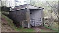
Approaching the well from the small car park (having tripped over the low lying fence wire suspended 2 inches from the ground between the gate posts- beware!), we became aware of the strong smell of sulphur from about 10m away.
Taking a very deep breath of clean air, I ventured into the dark, dark, dank well house, and managed to take a few photos of the tunnel bringing water into the first of two troughs. No water flow was evident at the time of our visit, but there had been a prolonged dry period before hand.
Another spring appears to surface some metres to the south of the well, creating a boggy area with small ponds.
Looking down over the iron railing near the well house to the gorge below, we spotted a series of small waterfalls. Further north, there is a larger waterfall marked on the map, but by this time it was late evening, and we wanted to go home, so didn't venture further.
")
Does anyone have any further historical details or information about this healing well, please?
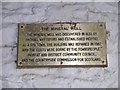
Canmore 48351 tells us this sulphurous spring was discovered in around 1640, although the small plaque inside the well more specifically says Rachael Whyteford came across it in 1633. The well quickly became famous for its curative powers, aiding cures for 'scrophulous and scorbutic complaints'. The water was eventually piped into the town, and established Moffat as a spa town.
The spring must have existed well before this time, and I am seeking any information prior to the 17th century, especially as the waters have very specific healing properties.
The well house is now very run down, and at the time of our visit (early evening), deep in shadow. There is a small car park at NT 09189 07183, where a gate (beware the wire running just above ground level) leads into the small meadow containing the well and well house. Just to its east is a rusty iron railing which prevents the visitor from plunging down into the narrow, deep gorge or Birnock Water, with its series of small waterfalls, below.
A very strong smell of sulphur emanates from the well house; we smelt it within a good 10m of the well house. Another small spring creates a small boggy area just to the south east of the well house.
Within the well house (I recommend visitors to take a very deep breath of clean air before entering!), the water emerges through a small tunnel into a (now stagnant) well pool, which has thick, black and green deposits around it. There had been a prolonged dry period just before our visit; no water could be seen emerging from the well, although a pipe could be seen which fed water from the well down the rock face into the stream below.
You may be viewing yesterday's version of this page. To see the most up to date information please register for a free account.
")
")
")
Do not use the above information on other web sites or publications without permission of the contributor.
Nearby Images from Geograph Britain and Ireland:

©2009(licence)

©2011(licence)
©2022(licence)

©2023(licence)
©2011(licence)
The above images may not be of the site on this page, they are loaded from Geograph.
Please Submit an Image of this site or go out and take one for us!
Click here to see more info for this site
Nearby sites
Key: Red: member's photo, Blue: 3rd party photo, Yellow: other image, Green: no photo - please go there and take one, Grey: site destroyed
Download sites to:
KML (Google Earth)
GPX (GPS waypoints)
CSV (Garmin/Navman)
CSV (Excel)
To unlock full downloads you need to sign up as a Contributory Member. Otherwise downloads are limited to 50 sites.
Turn off the page maps and other distractions
Nearby sites listing. In the following links * = Image available
3.5km SSW 193° Dyke Row* Stone Row / Alignment (NT0837503820)
7.3km S 170° Poldean menhir* Standing Stone (Menhir) (NT1037900011)
7.4km ENE 69° Peatshiel Sike* Standing Stone (Menhir) (NT16190972)
8.3km SSE 168° Chapman's Stone* Standing Stone (Menhir) (NY1078398986)
9.8km SSW 210° Stiddrig* Cairn (NY04139877)
10.3km SW 220° Lonnachie Rig Cairn (NY024995)
11.1km SSE 165° Pumplaburn* Cairn (NY11869644)
11.3km SSE 160° Wamphray Place* Misc. Earthwork (NY12829648)
11.4km SSE 159° St Cuthbert's Church (Wamphray)* Ancient Cross (NY1307096462)
12.2km SSE 156° Kirkhill* Stone Circle (NY1397895929)
12.9km S 170° Skip Knowe* Standing Stone (Menhir) (NY1118094430)
13.8km SSW 191° Crunzierton Wood Scooped Settlement* Ancient Village or Settlement (NY0625093750)
14.2km NNE 17° Talla Linnfoots* Cairn (NT13622069)
14.3km NNE 23° Megget Stone* Standing Stone (Menhir) (NT1505720292)
14.9km WNW 293° Daer valley Ancient Village or Settlement (NS956132)
15.6km N 354° Nether Dod* Stone Circle (NT08032279)
16.1km NW 305° Bodsberry Hill* Hillfort (NS963168)
16.8km N 360° Menzion* Standing Stones (NT0949023980)
16.8km N 360° Giant's Stone (Scottish Borders)* Standing Stone (Menhir) (NT09532399)
16.9km ESE 114° Naga Stupa(cairn)* Modern Stone Circle etc (NT246001)
17.8km S 178° Lochbrow Cursus* Cursus (NY0951489350)
18.0km S 178° Lochbrow Prehistoric Landscape* Ancient Village or Settlement (NY0942389153)
18.8km NW 319° Normangill Rig Cairn* Cairn (NS97092153)
18.8km S 179° Archwood Hill* Hillfort (NY0911488380)
19.0km SW 222° Gulfhill Rig Cairn (NX963933)
View more nearby sites and additional images


 We would like to know more about this location. Please feel free to add a brief description and any relevant information in your own language.
 Wir möchten mehr über diese Stätte erfahren. Bitte zögern Sie nicht, eine kurze Beschreibung und relevante Informationen in Deutsch hinzuzufügen.
 Nous aimerions en savoir encore un peu sur les lieux. S'il vous plaît n'hesitez pas à ajouter une courte description et tous les renseignements pertinents dans votre propre langue.
 Quisieramos informarnos un poco más de las lugares. No dude en añadir una breve descripción y otros datos relevantes en su propio idioma.