<< Our Photo Pages >> Devil's Lapful - Long Barrow in England in Northumberland
Submitted by paulxtr on Sunday, 12 July 2020 Page Views: 1396
Neolithic and Bronze AgeSite Name: Devil's LapfulCountry: England County: Northumberland Type: Long Barrow
Nearest Village: Kielder
Map Ref: NY6419392866
Latitude: 55.228702N Longitude: 2.564496W
Condition:
| 5 | Perfect |
| 4 | Almost Perfect |
| 3 | Reasonable but with some damage |
| 2 | Ruined but still recognisable as an ancient site |
| 1 | Pretty much destroyed, possibly visible as crop marks |
| 0 | No data. |
| -1 | Completely destroyed |
| 5 | Superb |
| 4 | Good |
| 3 | Ordinary |
| 2 | Not Good |
| 1 | Awful |
| 0 | No data. |
| 5 | Can be driven to, probably with disabled access |
| 4 | Short walk on a footpath |
| 3 | Requiring a bit more of a walk |
| 2 | A long walk |
| 1 | In the middle of nowhere, a nightmare to find |
| 0 | No data. |
| 5 | co-ordinates taken by GPS or official recorded co-ordinates |
| 4 | co-ordinates scaled from a detailed map |
| 3 | co-ordinates scaled from a bad map |
| 2 | co-ordinates of the nearest village |
| 1 | co-ordinates of the nearest town |
| 0 | no data |
Internal Links:
External Links:
")
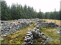
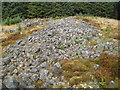
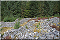
The remains of a long cairn of Neolithic date situated on the south west slope of Castle Hill commanding extensive views southwards.
The long cairn, orientated NNE to SSW, measures a maximum of 60m long and 14m wide and stands to a maximum height of 2m. It has been constructed of rounded boulders and some stone slabs with smaller stones around the edge.
Source: Historic England
You may be viewing yesterday's version of this page. To see the most up to date information please register for a free account.
Do not use the above information on other web sites or publications without permission of the contributor.
Nearby Images from Geograph Britain and Ireland:
©2006(licence)
©2006(licence)
©2008(licence)
©2009(licence)

©2008(licence)
The above images may not be of the site on this page, they are loaded from Geograph.
Please Submit an Image of this site or go out and take one for us!
Click here to see more info for this site
Nearby sites
Key: Red: member's photo, Blue: 3rd party photo, Yellow: other image, Green: no photo - please go there and take one, Grey: site destroyed
Download sites to:
KML (Google Earth)
GPX (GPS waypoints)
CSV (Garmin/Navman)
CSV (Excel)
To unlock full downloads you need to sign up as a Contributory Member. Otherwise downloads are limited to 50 sites.
Turn off the page maps and other distractions
Nearby sites listing. In the following links * = Image available
2.3km NNE 14° Gibbie's Knowe (Kielder)* Ancient Village or Settlement (NY6474595077)
7.6km N 356° The Kielder Stone* Natural Stone / Erratic / Other Natural Feature (NT63690050)
8.1km NW 312° Caddrounburn Calvert* Ancient Village or Settlement (NY58199836)
13.1km WNW 289° Ninestanes Rig* Stone Circle (NY51809731)
13.4km WSW 256° Castleton (Newcastleton)* Ancient Cross (NY51108983)
13.5km WSW 257° Old Castleton (Newcastleton)* Misc. Earthwork (NY50978997)
13.5km ESE 105° Sidwood Iron Age Settlement* Ancient Village or Settlement (NY77288925)
14.1km WNW 283° The Buck Stone (Buckstone Rig)* Standing Stone (Menhir) (NY50509622)
14.3km NNE 23° Elsdon Stone Circle Stone Circle (NT700060)
15.5km ENE 58° Three Kings* Stone Circle (NT7742500922)
16.2km ENE 57° Byrness Forest Office Site Rock Art (NT7794101470)
16.5km N 357° Southdean Law* Hillfort (NT63500938)
16.9km N 10° Shaw Craigs Hillfort (NT67270945)
17.3km WSW 240° Carby Hill* Ancient Village or Settlement (NY4906084360)
17.6km ENE 58° Dour Hill Long Cairn c* Rock Art (NT7917002158)
17.6km E 91° Padon Hill b Rock Art (NY8183292339)
17.6km ENE 58° Dour Hill Long Cairn a Rock Art (NT7920302130)
17.6km ENE 58° Dour Hill Long Cairn d & e Rock Art (NT7920002140)
17.6km ENE 58° Dour Hill Long Cairn b* Rock Art (NT7920302142)
17.6km ENE 58° Dour Hill (Rochester)* Chambered Cairn (NT79230212)
17.8km E 92° Padon Hill N01 Rock Art (NY8199292157)
17.8km E 92° Padon Hill a Rock Art (NY8199692154)
17.8km WSW 247° Milnholm (Newcastleton)* Ancient Cross (NY4763986111)
18.0km SSW 202° Grey Hill Settlement Ancient Village or Settlement (NY57317626)
18.0km ENE 65° Bellshiel Law 2f Rock Art (NT8064400188)
View more nearby sites and additional images


 We would like to know more about this location. Please feel free to add a brief description and any relevant information in your own language.
 Wir möchten mehr über diese Stätte erfahren. Bitte zögern Sie nicht, eine kurze Beschreibung und relevante Informationen in Deutsch hinzuzufügen.
 Nous aimerions en savoir encore un peu sur les lieux. S'il vous plaît n'hesitez pas à ajouter une courte description et tous les renseignements pertinents dans votre propre langue.
 Quisieramos informarnos un poco más de las lugares. No dude en añadir una breve descripción y otros datos relevantes en su propio idioma.