<< Our Photo Pages >> Ballyhemlin - Standing Stone (Menhir) in Ireland (Northern) in Co. Down
Submitted by ID on Monday, 09 March 2015 Page Views: 3008
Neolithic and Bronze AgeSite Name: Ballyhemlin Alternative Name: BallyhalbertCountry: Ireland (Northern)
NOTE: This site is 2.138 km away from the location you searched for.
County: Co. Down Type: Standing Stone (Menhir)
Nearest Town: Donaghadee Nearest Village: Ballyhalbert
Map Ref: J6407064750
Latitude: 54.504599N Longitude: 5.467849W
Condition:
| 5 | Perfect |
| 4 | Almost Perfect |
| 3 | Reasonable but with some damage |
| 2 | Ruined but still recognisable as an ancient site |
| 1 | Pretty much destroyed, possibly visible as crop marks |
| 0 | No data. |
| -1 | Completely destroyed |
| 5 | Superb |
| 4 | Good |
| 3 | Ordinary |
| 2 | Not Good |
| 1 | Awful |
| 0 | No data. |
| 5 | Can be driven to, probably with disabled access |
| 4 | Short walk on a footpath |
| 3 | Requiring a bit more of a walk |
| 2 | A long walk |
| 1 | In the middle of nowhere, a nightmare to find |
| 0 | No data. |
| 5 | co-ordinates taken by GPS or official recorded co-ordinates |
| 4 | co-ordinates scaled from a detailed map |
| 3 | co-ordinates scaled from a bad map |
| 2 | co-ordinates of the nearest village |
| 1 | co-ordinates of the nearest town |
| 0 | no data |
Internal Links:
External Links:
")
I have been told that the stone was egg shaped and a good six foot high, when pulled up it rolled down towards the (Springvale) road ending up in the verge, a hunt has not turned up any possibles.
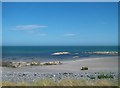
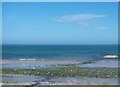
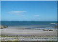
The site is on a small ridge with stunning views south and east. Visible to the south is Ballyhalbert Motte and Stone with Burgh Head the most easterly point in NI in the distance, to the east across the North Channel is Port Patrick.
The small headland (Quay Rocks) to the east of the site keeps eroding out pieces of mega-fauna, I have found several teeth and bones at the site. A partial set of Giant Red Deer Antlers were found buried on the beach during the 90's. The area is thought to where the last land bridge between NI and Scotland was located.
SMRNo = DOW018003
You may be viewing yesterday's version of this page. To see the most up to date information please register for a free account.
")
")
")
")
Do not use the above information on other web sites or publications without permission of the contributor.
Nearby Images from Geograph Britain and Ireland:

©2013(licence)
©2013(licence)
©2013(licence)
©2013(licence)
![J6464 : Ballyhalbert beach [3] by Rossographer](https://s2.geograph.org.uk/photos/80/65/806570_31c2c7bc_120x120.jpg)
©2008(licence)
The above images may not be of the site on this page, they are loaded from Geograph.
Please Submit an Image of this site or go out and take one for us!
Click here to see more info for this site
Nearby sites
Click here to view sites on an interactive map of the areaKey: Red: member's photo, Blue: 3rd party photo, Yellow: other image, Green: no photo - please go there and take one, Grey: site destroyed
Download sites to:
KML (Google Earth)
GPX (GPS waypoints)
CSV (Garmin/Navman)
CSV (Excel)
To unlock full downloads you need to sign up as a Contributory Member. Otherwise downloads are limited to 50 sites.
Turn off the page maps and other distractions
Nearby sites listing. In the following links * = Image available
1.4km SSE 156° Ballyhalbert Motte* Standing Stones (J6467563509)
9.1km WNW 303° Mount Stewart Cist* Cist (J5624069380)
12.5km S 189° Ballyrusley* Stone Row / Alignment (J6262052280)
13.4km W 264° Ballymartin Rock Art Rock Art (J50766285)
13.7km NNW 342° Templepatrick* Modern Stone Circle etc (J5935077610)
15.3km S 187° Millin Bay* Burial Chamber or Dolmen (J628495)
15.3km NNW 338° Carryreagh Standing Stone (Menhir) (J5790078820)
15.8km NNW 337° Hogstown Standing Stone (Menhir) (J57257904)
16.4km SSW 211° Audleystown Court Tomb* Court Tomb (J562503)
16.5km SSW 208° Castleward Standing Stones (J569499)
16.9km W 280° Ballygraffan Portal Tomb* Portal Tomb
18.5km NNW 340° Portavoe* Standing Stone (Menhir)
19.6km NW 314° Conlig Standing Stone* Standing Stone (Menhir) (J49377783)
19.8km SSW 209° Castle Mahon* Stone Circle (J552470)
20.7km SSW 210° Carrownacaw Long Stone* Standing Stone (Menhir)
21.0km SSW 211° Loughmoney* Portal Tomb (NW63890021)
21.3km NW 322° North Down Museum* Museum (NW634352)
21.4km WNW 297° Greengraves* Portal Tomb (J4454073630)
22.4km SSW 212° Slievenagriddle* Burial Chamber or Dolmen (J528453)
22.7km SSW 211° Ballyalton Court Tomb* Court Tomb
25.4km SW 220° Mound of Down* Misc. Earthwork
25.5km SW 220° Down County Museum* Museum
26.0km NW 307° Ballintaggart court tomb* Court Tomb (J4275379801)
28.3km SW 230° Annadorn Dolmen (Loughinisland)* Chambered Tomb (NW52870072)
29.1km SW 215° Ballynoe* Stone Circle (J4812740378)
View more nearby sites and additional images


 We would like to know more about this location. Please feel free to add a brief description and any relevant information in your own language.
 Wir möchten mehr über diese Stätte erfahren. Bitte zögern Sie nicht, eine kurze Beschreibung und relevante Informationen in Deutsch hinzuzufügen.
 Nous aimerions en savoir encore un peu sur les lieux. S'il vous plaît n'hesitez pas à ajouter une courte description et tous les renseignements pertinents dans votre propre langue.
 Quisieramos informarnos un poco más de las lugares. No dude en añadir una breve descripción y otros datos relevantes en su propio idioma.