<< Our Photo Pages >> Kissing Stones - Natural Stone / Erratic / Other Natural Feature in England in Derbyshire
Submitted by funsize on Monday, 04 June 2007 Page Views: 13705
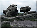
Natural PlacesSite Name: Kissing Stones Alternative Name: Wain StonesCountry: England County: Derbyshire Type: Natural Stone / Erratic / Other Natural Feature
Nearest Town: Glossop
Map Ref: SK091959
Latitude: 53.459773N Longitude: 1.864413W
Condition:
| 5 | Perfect |
| 4 | Almost Perfect |
| 3 | Reasonable but with some damage |
| 2 | Ruined but still recognisable as an ancient site |
| 1 | Pretty much destroyed, possibly visible as crop marks |
| 0 | No data. |
| -1 | Completely destroyed |
| 5 | Superb |
| 4 | Good |
| 3 | Ordinary |
| 2 | Not Good |
| 1 | Awful |
| 0 | No data. |
| 5 | Can be driven to, probably with disabled access |
| 4 | Short walk on a footpath |
| 3 | Requiring a bit more of a walk |
| 2 | A long walk |
| 1 | In the middle of nowhere, a nightmare to find |
| 0 | No data. |
| 5 | co-ordinates taken by GPS or official recorded co-ordinates |
| 4 | co-ordinates scaled from a detailed map |
| 3 | co-ordinates scaled from a bad map |
| 2 | co-ordinates of the nearest village |
| 1 | co-ordinates of the nearest town |
| 0 | no data |
Internal Links:
External Links:
")
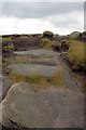
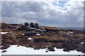
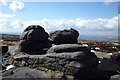
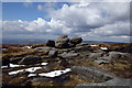
The Kissing Stones, part of the Wain Stones, are a natural sandstone outcrop. They have been weathered by the unrelenting weather up on Bleaklow, the largest mountain plateau in the Peak District National Park. These stones are iconic but I can find little history relating to them. For the best view of the simulacrum, view the stones from the west. If visiting, beware bad weather. Come well prepared!
You may be viewing yesterday's version of this page. To see the most up to date information please register for a free account.
Do not use the above information on other web sites or publications without permission of the contributor.
Nearby Images from Geograph Britain and Ireland:
©2011(licence)
©2016(licence)
©2016(licence)
©2016(licence)
©2016(licence)
The above images may not be of the site on this page, they are loaded from Geograph.
Please Submit an Image of this site or go out and take one for us!
Click here to see more info for this site
Nearby sites
Key: Red: member's photo, Blue: 3rd party photo, Yellow: other image, Green: no photo - please go there and take one, Grey: site destroyed
Download sites to:
KML (Google Earth)
GPX (GPS waypoints)
CSV (Garmin/Navman)
CSV (Excel)
To unlock full downloads you need to sign up as a Contributory Member. Otherwise downloads are limited to 50 sites.
Turn off the page maps and other distractions
Nearby sites listing. In the following links * = Image available
4.1km NW 319° Highstones earthwork* Misc. Earthwork (SK064990)
5.5km WSW 244° Carr House Lane standing stone Standing Stone (Menhir) (SK041935)
6.3km SSW 205° Kinder Scout I Round Barrow(s) (SK06439014)
6.4km W 266° Mouselow Castle Hillfort (SK027954)
6.5km SSW 201° Kinder Scout II Round Barrow(s) (SK06728981)
6.7km SSW 201° Cairn on Kinder Scout Cairn (SK067896)
7.4km SSW 193° Mermaid's Pool* Holy Well or Sacred Spring (SK074887)
8.1km WSW 240° Coombes Edge* Ring Cairn (SK0204591892)
8.3km WSW 251° Hargate Hill* Standing Stone (Menhir) (SK01239315)
8.5km S 189° Cluther Rocks* Ancient Mine, Quarry or other Industry (SK078875)
8.8km S 170° Grindsbrook Clough, Edale* Rock Art (SK106872)
8.9km NNW 343° Holgate Howe Cup & Ringmarks Rock Art (SE064044)
9.2km NNW 345° Holgate Howe Barrow Round Barrow(s) (SE067048)
9.4km N 350° Black Hill Cairn (SE074051)
9.4km S 191° Kinderlow Bowl Barrow* Round Barrow(s) (SK073867)
9.4km SSW 203° Upper Dole Field Well* Holy Well or Sacred Spring (SK054872)
9.6km SSE 153° Druids' Stone* Natural Stone / Erratic / Other Natural Feature (SK135874)
9.8km WSW 239° Chisworth Cupmarked stone* Rock Art (SK007909)
9.8km SSW 202° Tunstead Clough* Ancient Village or Settlement (SK055868)
9.8km WSW 240° Robin Hood's Picking Rods* Ancient Cross (SK0060990941)
9.9km WSW 236° Ringstones (new circle at Near Slack Farm)* Modern Stone Circle etc (SK0087290394)
9.9km S 188° Edale Cross* Ancient Cross (SK0772586092)
10.1km W 278° Hobson Moor Cairn II Cairn (SJ991972)
10.2km SSE 147° The Druids Altar Round Barrow(s) (SK147874)
10.3km W 277° Buckton Edge Cairn (SJ989972)
View more nearby sites and additional images


 We would like to know more about this location. Please feel free to add a brief description and any relevant information in your own language.
 Wir möchten mehr über diese Stätte erfahren. Bitte zögern Sie nicht, eine kurze Beschreibung und relevante Informationen in Deutsch hinzuzufügen.
 Nous aimerions en savoir encore un peu sur les lieux. S'il vous plaît n'hesitez pas à ajouter une courte description et tous les renseignements pertinents dans votre propre langue.
 Quisieramos informarnos un poco más de las lugares. No dude en añadir una breve descripción y otros datos relevantes en su propio idioma.