<< Our Photo Pages >> Edale Cross - Ancient Cross in England in Derbyshire
Submitted by Boggart on Saturday, 19 March 2011 Page Views: 17307
Early Medieval (Dark Age)Site Name: Edale CrossCountry: England County: Derbyshire Type: Ancient Cross
Nearest Village: Hayfield and Edale
Map Ref: SK0772586092
Latitude: 53.371635N Longitude: 1.885359W
Condition:
| 5 | Perfect |
| 4 | Almost Perfect |
| 3 | Reasonable but with some damage |
| 2 | Ruined but still recognisable as an ancient site |
| 1 | Pretty much destroyed, possibly visible as crop marks |
| 0 | No data. |
| -1 | Completely destroyed |
| 5 | Superb |
| 4 | Good |
| 3 | Ordinary |
| 2 | Not Good |
| 1 | Awful |
| 0 | No data. |
| 5 | Can be driven to, probably with disabled access |
| 4 | Short walk on a footpath |
| 3 | Requiring a bit more of a walk |
| 2 | A long walk |
| 1 | In the middle of nowhere, a nightmare to find |
| 0 | No data. |
| 5 | co-ordinates taken by GPS or official recorded co-ordinates |
| 4 | co-ordinates scaled from a detailed map |
| 3 | co-ordinates scaled from a bad map |
| 2 | co-ordinates of the nearest village |
| 1 | co-ordinates of the nearest town |
| 0 | no data |
Internal Links:
External Links:
")
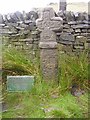
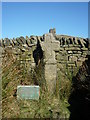
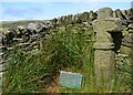
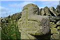
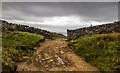
The cross was thrown down from its original position and its base and part of the shaft are missing. It was found buried in peat by local farmers who re-erected it and carved their initials onto the front with the date 1810.
The cross is situated close to Kinder Low End at the summit of the bridle road from Hayfield to Edale at an altitude of 1750 feet.
(Not strictly in date but added in memory of my fixing the Gallery slowness bug that has been driving the admins mad for longer than we can all remember - thanks for your patience admins! 19th March 2011 - MegP Ed)
You may be viewing yesterday's version of this page. To see the most up to date information please register for a free account.
Do not use the above information on other web sites or publications without permission of the contributor.
Nearby Images from Geograph Britain and Ireland:
©2019(licence)
©2010(licence)
©2012(licence)
©2012(licence)
©2015(licence)
The above images may not be of the site on this page, they are loaded from Geograph.
Please Submit an Image of this site or go out and take one for us!
Click here to see more info for this site
Nearby sites
Key: Red: member's photo, Blue: 3rd party photo, Yellow: other image, Green: no photo - please go there and take one, Grey: site destroyed
Download sites to:
KML (Google Earth)
GPX (GPS waypoints)
CSV (Garmin/Navman)
CSV (Excel)
To unlock full downloads you need to sign up as a Contributory Member. Otherwise downloads are limited to 50 sites.
Turn off the page maps and other distractions
Nearby sites listing. In the following links * = Image available
741m NW 325° Kinderlow Bowl Barrow* Round Barrow(s) (SK073867)
1.4km N 3° Cluther Rocks* Ancient Mine, Quarry or other Industry (SK078875)
2.2km W 268° Fog Field Well* Holy Well or Sacred Spring (SK05578602)
2.2km W 263° Coldwell Clough Anglo Saxon cross Ancient Cross (SK055858)
2.3km WSW 247° Mount Famine burial cist* Cist (SK056852)
2.3km WNW 288° Tunstead Clough* Ancient Village or Settlement (SK055868)
2.4km W 274° White Lady standing stone* Standing Stone (Menhir) (SK0534286250)
2.6km WNW 296° Upper Dole Field Well* Holy Well or Sacred Spring (SK054872)
2.6km N 353° Mermaid's Pool* Holy Well or Sacred Spring (SK074887)
3.1km ENE 69° Grindsbrook Clough, Edale* Rock Art (SK106872)
3.2km SSE 168° Green Low ringcairn* Ring Cairn (SK084830)
3.4km W 280° Whitworth Well* Holy Well or Sacred Spring (SK0437786691)
3.7km NNW 344° Cairn on Kinder Scout Cairn (SK067896)
3.8km W 280° Watery Hey Well* Holy Well or Sacred Spring (SK0399986733)
3.8km NNW 345° Kinder Scout II Round Barrow(s) (SK06728981)
3.8km S 170° Ford Hall Cairn (SK084823)
4.2km NNW 342° Kinder Scout I Round Barrow(s) (SK06439014)
4.3km SE 127° The Lords Seat* Round Barrow(s) (SK112835)
4.4km S 179° Mag Low* Round Barrow(s) (SK078817)
4.9km WSW 239° Chinley Churn Barrow Round Barrow(s) (SK035836)
5.3km SSW 198° Nanny's Well (Chapel le Frith) Holy Well or Sacred Spring (SK061810)
5.6km ESE 117° Mam Tor Barrow Round Barrow(s) (SK127836)
5.6km ESE 115° Mam Tor* Hillfort (SK128837)
5.6km SSW 201° St Thomas Becket (Chapel en le Frith)* Ancient Cross (SK0574580820)
5.8km SSE 147° Perryfoot Long Barrow (SK109812)
View more nearby sites and additional images


 We would like to know more about this location. Please feel free to add a brief description and any relevant information in your own language.
 Wir möchten mehr über diese Stätte erfahren. Bitte zögern Sie nicht, eine kurze Beschreibung und relevante Informationen in Deutsch hinzuzufügen.
 Nous aimerions en savoir encore un peu sur les lieux. S'il vous plaît n'hesitez pas à ajouter une courte description et tous les renseignements pertinents dans votre propre langue.
 Quisieramos informarnos un poco más de las lugares. No dude en añadir una breve descripción y otros datos relevantes en su propio idioma.