<< Our Photo Pages >> Druids' Stone - Natural Stone / Erratic / Other Natural Feature in England in Derbyshire
Submitted by Boggart on Saturday, 27 October 2012 Page Views: 7344
Natural PlacesSite Name: Druids' StoneCountry: England
NOTE: This site is 1.943 km away from the location you searched for.
County: Derbyshire Type: Natural Stone / Erratic / Other Natural Feature
Nearest Village: Hayfield/Edale
Map Ref: SK135874
Latitude: 53.383277N Longitude: 1.798507W
Condition:
| 5 | Perfect |
| 4 | Almost Perfect |
| 3 | Reasonable but with some damage |
| 2 | Ruined but still recognisable as an ancient site |
| 1 | Pretty much destroyed, possibly visible as crop marks |
| 0 | No data. |
| -1 | Completely destroyed |
| 5 | Superb |
| 4 | Good |
| 3 | Ordinary |
| 2 | Not Good |
| 1 | Awful |
| 0 | No data. |
| 5 | Can be driven to, probably with disabled access |
| 4 | Short walk on a footpath |
| 3 | Requiring a bit more of a walk |
| 2 | A long walk |
| 1 | In the middle of nowhere, a nightmare to find |
| 0 | No data. |
| 5 | co-ordinates taken by GPS or official recorded co-ordinates |
| 4 | co-ordinates scaled from a detailed map |
| 3 | co-ordinates scaled from a bad map |
| 2 | co-ordinates of the nearest village |
| 1 | co-ordinates of the nearest town |
| 0 | no data |
Internal Links:
External Links:
I have visited· I would like to visit
43559959 would like to visit
")
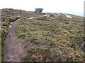
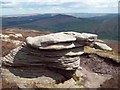
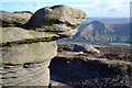
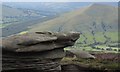
An outcrop of grit stone on Kinder Scout. The rock has gained the folklore of being the site of Druid sacrifices! The indentations on top of the stone, which are due to natural erosion, are believed to be the receptacles for offerings to the Gods. As with most folklore there is always a grain of truth surrounding such sites !
Close by on Nether Moor is the site of another supposed Druidic altar.
You may be viewing yesterday's version of this page. To see the most up to date information please register for a free account.
")
")
Do not use the above information on other web sites or publications without permission of the contributor.
Nearby Images from Geograph Britain and Ireland:
©2008(licence)
©2012(licence)
©2012(licence)
©2012(licence)
©2014(licence)
The above images may not be of the site on this page, they are loaded from Geograph.
Please Submit an Image of this site or go out and take one for us!
Click here to see more info for this site
Nearby sites
Key: Red: member's photo, Blue: 3rd party photo, Yellow: other image, Green: no photo - please go there and take one, Grey: site destroyed
Download sites to:
KML (Google Earth)
GPX (GPS waypoints)
CSV (Garmin/Navman)
CSV (Excel)
To unlock full downloads you need to sign up as a Contributory Member. Otherwise downloads are limited to 50 sites.
Turn off the page maps and other distractions
Nearby sites listing. In the following links * = Image available
1.2km E 90° The Druids Altar Round Barrow(s) (SK147874)
2.9km W 266° Grindsbrook Clough, Edale* Rock Art (SK106872)
3.5km S 177° Russet Well* Holy Well or Sacred Spring (SK137839)
3.8km S 191° Mam Tor* Hillfort (SK128837)
3.9km SSW 192° Mam Tor Barrow Round Barrow(s) (SK127836)
4.4km S 179° Treak Cliff Sepulchral Cave* Cave or Rock Shelter (SK136830)
4.5km SSW 211° The Lords Seat* Round Barrow(s) (SK112835)
4.8km SSE 164° Lady's well (Cavedale) Holy Well or Sacred Spring (SK148828)
4.9km E 94° Crook Hill* Stone Circle (SK184871)
5.0km SSE 163° Cave Dale 2* Cave or Rock Shelter (SK150826)
5.0km ENE 63° Pike Low* Cairn (SK180897)
5.4km SE 137° St Peter (Hope)* Ancient Cross (SK1725583445)
5.6km SE 144° The Folly Round Barrow(s) (SK168829)
5.7km W 271° Cluther Rocks* Ancient Mine, Quarry or other Industry (SK078875)
5.9km WSW 257° Edale Cross* Ancient Cross (SK0772586092)
6.2km WNW 282° Mermaid's Pool* Holy Well or Sacred Spring (SK074887)
6.2km W 264° Kinderlow Bowl Barrow* Round Barrow(s) (SK073867)
6.5km SSW 197° Eldon Hill* Round Barrow(s) (SK11568114)
6.6km SSW 193° Eldon Hill 2* Round Barrow(s) (SK12028099)
6.7km SE 144° Bath Spring Holy Well or Sacred Spring (SK174820)
6.7km SSW 203° Perryfoot Long Barrow (SK109812)
6.7km SW 229° Green Low ringcairn* Ring Cairn (SK084830)
6.9km E 94° Ladybower Tor* Rock Art (SK204869)
6.9km S 184° Ox Low* Round Barrow(s) (SK130805)
7.1km WNW 288° Cairn on Kinder Scout Cairn (SK067896)
View more nearby sites and additional images


 We would like to know more about this location. Please feel free to add a brief description and any relevant information in your own language.
 Wir möchten mehr über diese Stätte erfahren. Bitte zögern Sie nicht, eine kurze Beschreibung und relevante Informationen in Deutsch hinzuzufügen.
 Nous aimerions en savoir encore un peu sur les lieux. S'il vous plaît n'hesitez pas à ajouter une courte description et tous les renseignements pertinents dans votre propre langue.
 Quisieramos informarnos un poco más de las lugares. No dude en añadir una breve descripción y otros datos relevantes en su propio idioma.