<< Our Photo Pages >> Llanbadarn Fawr Celtic Crosses - Ancient Cross in Wales in Ceredigion
Submitted by AngieLake on Monday, 10 November 2008 Page Views: 7792
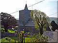
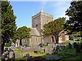
Early Medieval (Dark Age)Site Name: Llanbadarn Fawr Celtic Crosses Alternative Name: Llanbadarn Fawr 1 (CD 4), Llanbadarn Fawr 2 (CD5)Country: Wales
NOTE: This site is 0.342 km away from the location you searched for.
County: Ceredigion Type: Ancient Cross
Nearest Town: Aberystwyth Nearest Village: Llanbadarn Fawr
Map Ref: SN59918101
Latitude: 52.409106N Longitude: 4.06093W
Condition:
| 5 | Perfect |
| 4 | Almost Perfect |
| 3 | Reasonable but with some damage |
| 2 | Ruined but still recognisable as an ancient site |
| 1 | Pretty much destroyed, possibly visible as crop marks |
| 0 | No data. |
| -1 | Completely destroyed |
| 5 | Superb |
| 4 | Good |
| 3 | Ordinary |
| 2 | Not Good |
| 1 | Awful |
| 0 | No data. |
| 5 | Can be driven to, probably with disabled access |
| 4 | Short walk on a footpath |
| 3 | Requiring a bit more of a walk |
| 2 | A long walk |
| 1 | In the middle of nowhere, a nightmare to find |
| 0 | No data. |
| 5 | co-ordinates taken by GPS or official recorded co-ordinates |
| 4 | co-ordinates scaled from a detailed map |
| 3 | co-ordinates scaled from a bad map |
| 2 | co-ordinates of the nearest village |
| 1 | co-ordinates of the nearest town |
| 0 | no data |
Internal Links:
External Links:
I have visited· I would like to visit
AngieLake has visited here
")
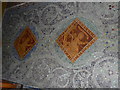
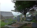
Precise dating of the crosses is difficult, but it is now believed that they may well be re-used pre-Christian standing stones. The large cross is made from granite, possibly from the Llyn Peninsula, and is one of only a few Welsh crosses to include figurative carving as well as the typical interlacing which was developed by the Christian Celts.
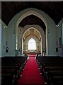
Re: the church - "Its cruciform plan and large central tower reflect its importance as the mother church of what was then the largest parish in Wales.
You may be viewing yesterday's version of this page. To see the most up to date information please register for a free account.
")
")
Do not use the above information on other web sites or publications without permission of the contributor.
Nearby Images from Geograph Britain and Ireland:
©2008(licence)
©2008(licence)
©2008(licence)
©2010(licence)
©2015(licence)
The above images may not be of the site on this page, they are loaded from Geograph.
Please Submit an Image of this site or go out and take one for us!
Click here to see more info for this site
Nearby sites
Key: Red: member's photo, Blue: 3rd party photo, Yellow: other image, Green: no photo - please go there and take one, Grey: site destroyed
Download sites to:
KML (Google Earth)
GPX (GPS waypoints)
CSV (Garmin/Navman)
CSV (Excel)
To unlock full downloads you need to sign up as a Contributory Member. Otherwise downloads are limited to 50 sites.
Turn off the page maps and other distractions
Nearby sites listing. In the following links * = Image available
113m SE 133° Y Garreg Fawr* Chambered Tomb (SN59998093)
471m WNW 301° Ffynnon Badarn* Holy Well or Sacred Spring (SN5951181263)
1.7km WSW 240° Pen Dinas (Aberystwyth)* Hillfort (SN5842080211)
1.8km WNW 295° Ceredigion Museum* Museum (SN583818)
2.0km WNW 283° Aberystwyth Gorsedd Circle* Modern Stone Circle etc (SN5794681533)
2.4km SSW 213° Castell Tan Y Bwlch Castle* Promontory Fort / Cliff Castle (SN5851079000)
2.6km SE 141° Old Warren Hill Hillfort (SN615789)
3.6km NE 40° Gorgerddan Round Barrow(s) (SN62328373)
3.7km NE 46° Plas Gogerddan* Stone Row / Alignment (SN626835)
3.7km NE 46° Plas Gogerddan Barrow* Round Barrow(s) (SN62658348)
3.8km NE 39° Gorgerddan Enclosure Ancient Village or Settlement (SN62418387)
4.0km NNE 33° Bow Street* Ancient Village or Settlement (SN6223584325)
4.8km NE 43° Hen Gaer Hillfort (SN633844)
5.3km NE 53° Penrhyncoch War Memorial Standing Stone (Menhir) (SN6422984058)
5.3km NNE 21° Ruel Uchaf Ancient Village or Settlement (SN620859)
5.5km SSE 166° Castell Pantmawr Hillfort (SN611756)
5.8km N 353° Cerig Y Gath Burial Chamber or Dolmen (SN59378678)
6.0km NE 46° Cwrt Enclosure Ancient Village or Settlement (SN64348503)
6.1km ENE 58° Bryntirion Well* Holy Well or Sacred Spring (SN65158407)
6.3km NNE 21° St Michael's Church Well Holy Well or Sacred Spring (SN62328687)
7.0km SSE 152° Pen-Y-Castell Enclosure Ancient Village or Settlement (SN62997468)
7.2km SSE 153° Llanilar Hillfort (SN62997454)
8.2km ENE 74° Darren Camp Cairn I Cairn (SN6789382997)
8.2km ENE 74° Darren Camp Cairn II Cairn (SN6789183010)
8.2km ENE 74° Darren Camp* Hillfort (SN67908302)
View more nearby sites and additional images


 We would like to know more about this location. Please feel free to add a brief description and any relevant information in your own language.
 Wir möchten mehr über diese Stätte erfahren. Bitte zögern Sie nicht, eine kurze Beschreibung und relevante Informationen in Deutsch hinzuzufügen.
 Nous aimerions en savoir encore un peu sur les lieux. S'il vous plaît n'hesitez pas à ajouter une courte description et tous les renseignements pertinents dans votre propre langue.
 Quisieramos informarnos un poco más de las lugares. No dude en añadir una breve descripción y otros datos relevantes en su propio idioma.