<< Text Pages >> Notter Tor - Ancient Village or Settlement in England in Cornwall
Submitted by Andy B on Saturday, 18 June 2011 Page Views: 5120
Multi-periodSite Name: Notter TorCountry: England
NOTE: This site is 0.551 km away from the location you searched for.
County: Cornwall Type: Ancient Village or Settlement
Nearest Village: Linkinhorne
Map Ref: SX27157377
Latitude: 50.538094N Longitude: 4.440607W
Condition:
| 5 | Perfect |
| 4 | Almost Perfect |
| 3 | Reasonable but with some damage |
| 2 | Ruined but still recognisable as an ancient site |
| 1 | Pretty much destroyed, possibly visible as crop marks |
| 0 | No data. |
| -1 | Completely destroyed |
| 5 | Superb |
| 4 | Good |
| 3 | Ordinary |
| 2 | Not Good |
| 1 | Awful |
| 0 | No data. |
| 5 | Can be driven to, probably with disabled access |
| 4 | Short walk on a footpath |
| 3 | Requiring a bit more of a walk |
| 2 | A long walk |
| 1 | In the middle of nowhere, a nightmare to find |
| 0 | No data. |
| 5 | co-ordinates taken by GPS or official recorded co-ordinates |
| 4 | co-ordinates scaled from a detailed map |
| 3 | co-ordinates scaled from a bad map |
| 2 | co-ordinates of the nearest village |
| 1 | co-ordinates of the nearest town |
| 0 | no data |
Be the first person to rate this site - see the 'Contribute!' box in the right hand menu.
Internal Links:
External Links:
Early Neolithic Tor Enclosure in Cornwall
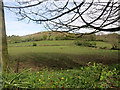
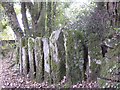
This site is situated on spur a between two watercourses on the southeast edge of Bodmin Moor. Two sections of fairly well preserved stone wall link outcrops of the tour on the southwestern side, however little investigation has been carried out upon them.
It is significantly lower than Stowe’s Pound which towers above it. To the east is the Bearah
Common tomb. On the southeast edge of Bodmin Moor, slightly below the nearby high tors.
Good views to the east where the ground falls sharply away and Dartmoor can be seen on the horizon. Poor views into the Moor, as the higher tors, Stowe’s Pound, Sharp Tor, etc., block the views.
Source: The Early Neolithic Tor Enclosures of Southwest Britain, Simon R. Davies
The University of Birmingham Ph.D Thesis (PDF)
You may be viewing yesterday's version of this page. To see the most up to date information please register for a free account.
Do not use the above information on other web sites or publications without permission of the contributor.
Nearby Images from Geograph Britain and Ireland:

©2020(licence)
©2015(licence)

©2015(licence)
©2011(licence)

©2015(licence)
The above images may not be of the site on this page, they are loaded from Geograph.
Please Submit an Image of this site or go out and take one for us!
Click here to see more info for this site
Nearby sites
Key: Red: member's photo, Blue: 3rd party photo, Yellow: other image, Green: no photo - please go there and take one, Grey: site destroyed
Download sites to:
KML (Google Earth)
GPX (GPS waypoints)
CSV (Garmin/Navman)
CSV (Excel)
To unlock full downloads you need to sign up as a Contributory Member. Otherwise downloads are limited to 50 sites.
Turn off the page maps and other distractions
Nearby sites listing. In the following links * = Image available
1.0km WNW 303° Bearah Common Long Cairn* Chambered Cairn (SX26327435)
1.6km W 266° Langstone downs Cairns* Cairn (SX255737)
1.7km WNW 294° Linkinhorne Reave Misc. Earthwork (SX2564274508)
1.8km WNW 285° Bearah Tramway Cist* Cist (SX254743)
1.8km W 266° Langstone Downs row Stone Row / Alignment (SX253737)
1.9km SW 225° Stowe's Pound* Ancient Village or Settlement (SX25787247)
1.9km WNW 284° Bearah Tramway Cairn* Cairn (SX25327430)
1.9km SW 223° The Cheesewring* Natural Stone / Erratic / Other Natural Feature (SX25787239)
2.1km SSW 205° Minions Settlement* Ancient Village or Settlement (SX262719)
2.2km SSW 210° Rillaton N Cairn* Cairn (SX26007195)
2.2km SSW 209° Rillaton Barrow* Round Barrow(s) (SX26027191)
2.2km WNW 296° Kilmar Tor* Rock Outcrop (SX252748)
2.2km WNW 297° Kilmar Tor propped stone* Natural Stone / Erratic / Other Natural Feature (SX2521374856)
2.2km NW 311° Twelve Men's Moor Cairns Barrow Cemetery (SX255753)
2.3km WNW 295° High Rock propped stone* Natural Stone / Erratic / Other Natural Feature (SX2509074809)
2.3km W 265° Withey Brook* Cairn (SX2482273656)
2.4km SW 214° The Hurlers Avenue* Multiple Stone Rows / Avenue (SX2576371864)
2.4km WNW 299° Kilmar Tor North Propped Stone* Natural Stone / Erratic / Other Natural Feature (SX2510874982)
2.4km W 280° Wardbrook Farm Cist* Cist (SX2481374281)
2.5km NW 305° Pyramid Stone (Kilmar Tor)* Natural Stone / Erratic / Other Natural Feature (SX25187526)
2.5km SSW 208° The Hurlers North* Stone Circle (SX25877159)
2.5km N 355° St Torney's Holy Well* Holy Well or Sacred Spring (SX27037631)
2.7km SSW 208° The Hurlers (N)* Stone Circle (SX25847145)
2.7km NW 309° Twelve men's moor cairn and cist* Cist (SX25117551)
2.7km SSW 207° The Hurlers causeway* Ancient Trackway (SX25837142)
View more nearby sites and additional images


 We would like to know more about this location. Please feel free to add a brief description and any relevant information in your own language.
 Wir möchten mehr über diese Stätte erfahren. Bitte zögern Sie nicht, eine kurze Beschreibung und relevante Informationen in Deutsch hinzuzufügen.
 Nous aimerions en savoir encore un peu sur les lieux. S'il vous plaît n'hesitez pas à ajouter une courte description et tous les renseignements pertinents dans votre propre langue.
 Quisieramos informarnos un poco más de las lugares. No dude en añadir una breve descripción y otros datos relevantes en su propio idioma.