<< Text Pages >> Indian God Rock - Rock Art in United States in Mid Atlantic
Submitted by aluta on Thursday, 08 November 2007 Page Views: 15647
Rock ArtSite Name: Indian God RockCountry: United States
NOTE: This site is 58.554 km away from the location you searched for.
Region: Mid Atlantic Type: Rock Art
Nearest Town: Franklin, PA
Latitude: 41.330000N Longitude: 79.824W
Condition:
| 5 | Perfect |
| 4 | Almost Perfect |
| 3 | Reasonable but with some damage |
| 2 | Ruined but still recognisable as an ancient site |
| 1 | Pretty much destroyed, possibly visible as crop marks |
| 0 | No data. |
| -1 | Completely destroyed |
| 5 | Superb |
| 4 | Good |
| 3 | Ordinary |
| 2 | Not Good |
| 1 | Awful |
| 0 | No data. |
| 5 | Can be driven to, probably with disabled access |
| 4 | Short walk on a footpath |
| 3 | Requiring a bit more of a walk |
| 2 | A long walk |
| 1 | In the middle of nowhere, a nightmare to find |
| 0 | No data. |
| 5 | co-ordinates taken by GPS or official recorded co-ordinates |
| 4 | co-ordinates scaled from a detailed map |
| 3 | co-ordinates scaled from a bad map |
| 2 | co-ordinates of the nearest village |
| 1 | co-ordinates of the nearest town |
| 0 | no data |
Internal Links:
External Links:
Cup and Ring marks / Rock Art in Mid Atlantic.
Indian God Rock is a sandstone petroglyph rock along the Allegheny River in Pennsylvania, USA.
The earliest of the rock art on it resembles rock art found on rocks in the Susquehanna River in the central part of the state, and was likely done by indigenous people well before the arrival of Europeans here. Here is a link to a page describing it. Doing a search on "Indian God Rock"+Franklin will yield more information.
You may be viewing yesterday's version of this page. To see the most up to date information please register for a free account.
Do not use the above information on other web sites or publications without permission of the contributor.
Nearby Images from Flickr
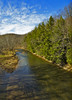
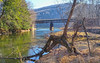

The above images may not be of the site on this page, but were taken nearby. They are loaded from Flickr so please click on them for image credits.
Click here to see more info for this site
Nearby sites
Click here to view sites on an interactive map of the areaKey: Red: member's photo, Blue: 3rd party photo, Yellow: other image, Green: no photo - please go there and take one, Grey: site destroyed
Download sites to:
KML (Google Earth)
GPX (GPS waypoints)
CSV (Garmin/Navman)
CSV (Excel)
To unlock full downloads you need to sign up as a Contributory Member. Otherwise downloads are limited to 50 sites.
Turn off the page maps and other distractions
Nearby sites listing. In the following links * = Image available
97.3km SSW 191° McKees Rocks Mound* Artificial Mound
104.1km SSW 204° Artificial Mound in Great Lakes Midwest* Artificial Mound
129.0km SSW 206° Meadowcroft Rockshelter* Cave or Rock Shelter
135.5km NE 55° Stone of Rock City Park Natural Stone / Erratic / Other Natural Feature
147.9km SSW 210° Hodgen's Cemetery Mound* Artificial Mound
148.6km WSW 250° Nobles Pond* Ancient Village or Settlement
160.2km W 262° Paleo Crossing Ancient Village or Settlement
175.3km SSW 207° Grave Creek Mound* Artificial Mound
187.8km SW 218° Barnesville Rock Art* Rock Art
210.9km SW 235° Porteus Mound* Artificial Mound
241.8km SSW 209° Reynolds Mound* Artificial Mound
246.4km WSW 246° McLaughlin Mound* Artificial Mound
246.4km WSW 248° Braddock Mound Artificial Mound
247.5km WSW 248° Raleigh Mound Artificial Mound
250.9km W 275° Danbury Site Ancient Village or Settlement
253.1km SSW 214° Marietta Earthworks - Capitolium* Artificial Mound
253.2km SW 214° Marietta Earthworks - Quadranaou* Pyramid / Mastaba
253.2km SSW 214° Marietta Earthworks - Conus* Artificial Mound
253.5km SSW 214° Campus Martius* Museum
253.6km SW 214° Marietta Earthworks* Misc. Earthwork
254.1km SW 235° Flint Ridge* Ancient Mine, Quarry or other Industry
257.0km WSW 243° Dixon Mound* Artificial Mound
260.1km WSW 238° Upham* Artificial Mound
260.5km SW 236° Tippett Mound Artificial Mound
261.2km WSW 239° Ferris Owen* Artificial Mound
View more nearby sites and additional images


 We would like to know more about this location. Please feel free to add a brief description and any relevant information in your own language.
 Wir möchten mehr über diese Stätte erfahren. Bitte zögern Sie nicht, eine kurze Beschreibung und relevante Informationen in Deutsch hinzuzufügen.
 Nous aimerions en savoir encore un peu sur les lieux. S'il vous plaît n'hesitez pas à ajouter une courte description et tous les renseignements pertinents dans votre propre langue.
 Quisieramos informarnos un poco más de las lugares. No dude en añadir una breve descripción y otros datos relevantes en su propio idioma.