<< Other Photo Pages >> Arpino Acropolis - Ancient Village or Settlement in Italy in Lazio/Roma
Submitted by ivanjohnson on Monday, 15 February 2016 Page Views: 3351
Multi-periodSite Name: Arpino Acropolis Alternative Name: Acropoli di ArpinoCountry: Italy
NOTE: This site is 7.87 km away from the location you searched for.
Region: Lazio/Roma Type: Ancient Village or Settlement
Nearest Town: Arpino
Latitude: 41.648942N Longitude: 13.618826E
Condition:
| 5 | Perfect |
| 4 | Almost Perfect |
| 3 | Reasonable but with some damage |
| 2 | Ruined but still recognisable as an ancient site |
| 1 | Pretty much destroyed, possibly visible as crop marks |
| 0 | No data. |
| -1 | Completely destroyed |
| 5 | Superb |
| 4 | Good |
| 3 | Ordinary |
| 2 | Not Good |
| 1 | Awful |
| 0 | No data. |
| 5 | Can be driven to, probably with disabled access |
| 4 | Short walk on a footpath |
| 3 | Requiring a bit more of a walk |
| 2 | A long walk |
| 1 | In the middle of nowhere, a nightmare to find |
| 0 | No data. |
| 5 | co-ordinates taken by GPS or official recorded co-ordinates |
| 4 | co-ordinates scaled from a detailed map |
| 3 | co-ordinates scaled from a bad map |
| 2 | co-ordinates of the nearest village |
| 1 | co-ordinates of the nearest town |
| 0 | no data |
Internal Links:
External Links:
I have visited· I would like to visit
lichen would like to visit
")
Arpino's ancient acropolis features well preserved Pelasgian cyclopean stone walls probably from the mid to late first millenium BC, including a unique and picturesque corbelled entry arch called the Arco a Sesto Acuta.
The ancient city of Arpinum dates back to at least the 7th century BC. Connected with the Pelasgi, the Volscian and Samnite people, it was captured by the Romans and granted civitas sine suffragio in 305 BC. The city gained Roman suffrage in 188 BC and the status of a municipium in 90 BC. After the 11th century it was ruled by the Normans, the Hohenstaufen and by the Papal States.
Arpino is the birthplace of Roman philosopher Cicero. There is an unconfirmed oral tradition that Marcus Vipsanius Agrippa was also a native of Arpinum.
You may be viewing yesterday's version of this page. To see the most up to date information please register for a free account.
")
")
")
")
Do not use the above information on other web sites or publications without permission of the contributor.
Nearby Images from Flickr
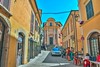
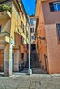
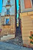
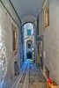
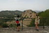
The above images may not be of the site on this page, but were taken nearby. They are loaded from Flickr so please click on them for image credits.
Click here to see more info for this site
Nearby sites
Click here to view sites on an interactive map of the areaKey: Red: member's photo, Blue: 3rd party photo, Yellow: other image, Green: no photo - please go there and take one, Grey: site destroyed
Download sites to:
KML (Google Earth)
GPX (GPS waypoints)
CSV (Garmin/Navman)
CSV (Excel)
To unlock full downloads you need to sign up as a Contributory Member. Otherwise downloads are limited to 50 sites.
Turn off the page maps and other distractions
Nearby sites listing. In the following links * = Image available
24.4km WNW 290° Alatri Acropolis* Hillfort
25.0km WNW 297° Alatri Temple* Ancient Temple
49.6km W 276° Giunone Moneta (Segni)* Ancient Village or Settlement
55.0km W 263° Antica Norba* Ancient Village or Settlement
60.7km N 353° Lu Termine* Standing Stone (Menhir)
61.2km SSE 159° Roccia San Sebastiano Cave or Rock Shelter
64.3km SW 224° Mura Ciclopiche San Felice Circeo Stone Fort or Dun
72.5km N 352° Fossa Standing Stones* Stone Row / Alignment
75.9km W 277° Nemi Temple of Diana* Ancient Temple
80.3km WSW 257° Nettuno Tomb Burial Chamber or Dolmen
96.1km WNW 286° Karnak Temple of Amun Lateran Obelisk* Standing Stone (Menhir)
97.2km WNW 287° Heliopolis Ramesses II Termini Obelisk* Standing Stone (Menhir)
97.9km WNW 286° Rome.* Ancient Village or Settlement
98.2km WNW 287° Lupercale Shrine* Cave or Rock Shelter
98.6km WNW 287° Sais - Piazza Minerva Obelisk* Standing Stone (Menhir)
99.1km WNW 287° Heliopolis Seti I Piazza del Popolo Obelisk* Standing Stone (Menhir)
100.7km WNW 287° Gregorian Etruscan Museum* Museum
111.8km SSE 147° Herculaneum Ancient Village or Settlement
123.2km SE 144° Pompeii* Ancient Village or Settlement
123.5km SE 144° Macellum of Pompeii* Modern Stone Circle etc
131.9km WNW 288° Cerveteri Necropoli della Banditaceia* Rock Cut Tomb
132.4km WNW 300° Sutri amphitheatre* Ancient Village or Settlement
132.4km WNW 300° Sutri Necropolis* Rock Cut Tomb
140.6km NW 322° Carsulae Ancient Village or Settlement
144.2km WNW 299° Barbarano Romano Etruscan Necropolis Chambered Tomb
View more nearby sites and additional images


 We would like to know more about this location. Please feel free to add a brief description and any relevant information in your own language.
 Wir möchten mehr über diese Stätte erfahren. Bitte zögern Sie nicht, eine kurze Beschreibung und relevante Informationen in Deutsch hinzuzufügen.
 Nous aimerions en savoir encore un peu sur les lieux. S'il vous plaît n'hesitez pas à ajouter une courte description et tous les renseignements pertinents dans votre propre langue.
 Quisieramos informarnos un poco más de las lugares. No dude en añadir una breve descripción y otros datos relevantes en su propio idioma.