



How a New Generation is Finding Ancient Sites Nobody Has Photographed Yet
Submitted by Andy_B on Monday, 19 October 2026 Page Views: 31
Resources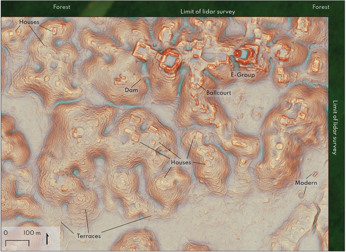
A quiet, fast-growing network of amateur site hunters is rewriting historical maps directly from their desks. They look for ancient tombs, megalithic enclosures, and desert ruins that have never seen a modern camera lens. Without university grants or heavy expedition gear, they open up satellite data and start scanning.
Our planet is covered in forgotten human footprints. Immense stretches of land across central Asian steppes, dry scrublands in Spain, and river basins in South America hold ancient earthworks that nearby residents pass every day without noticing. Until recently, finding these sites meant organizing long, punishing treks through difficult terrain. Today, anyone with a laptop can spot a subtle mound in an empty field, calculate the shadow angle, and realize they are looking at a three-thousand-year-old burial mound that no archaeologist has ever visited.
The Satellite Revolution and the Death of the Machete
Free orbital photography turned armchair exploration into a genuine science. Through open-access platforms like Sentinel Hub, Landsat, and standard mapping software, satellite images are sharp enough to pick out minor earth disturbances from space.That data matters because ancient stonework changes how vegetation grows. Buried stone walls restrict grass roots, making patches of vegetation dry out faster and turn pale yellow during heatwaves. Old ditches, on the other hand, trap organic soil and rainwater, showing up from above as vibrant green lines. In 2018, airborne laser scanning famously exposed over 61,000 unmapped Maya structures hiding under dense jungle canopies in Guatemala. It proved that millions of ancient sites remain undiscovered, waiting for someone with enough time to spot them.
Reading Shadows from Four Hundred Miles Above
Spotting an unrecorded ruin is rarely obvious. You cannot simply zoom in and expect to see a castle waiting for you. Most unphotographed monuments are eroded ditches, melted mud-brick piles, or stone circles leveled by tractors decades ago. To catch these faint outlines, hunters hunt for low-raking light.A trench that vanishes beneath the noon sun suddenly stands out at dawn. A tiny bump in a plowed field throws a dark shadow, highlighting a Bronze Age burial mound that looks like ordinary dirt to a passing tractor. Experienced screen hunters develop an instinct for straight lines, concentric rings, and right angles. Nature loves chaotic shapes, but humans build in geometry.
Drones: The Budget Helicopters of the Wilderness
Finding an anomaly on a satellite tile is only step one. Hunters need closer eyes, but rugged terrain often blocks the way. A decade ago, checking a remote ridge required hiring a bush plane or spending three days hiking through dense briars. Today, a budget drone inside a daypack solves the problem in twenty minutes.These lightweight flyers zoom over sheer ravines, swampy wetlands, and dense thorn thickets. An explorer standing safely beside a gravel road can guide a drone a mile up a canyon, hover twenty feet above an overgrown terrace, and snap the very first photographs of a stone watchtower that crumbled before the Middle Ages ended.
Midnight Screen Burnout and Digital Connections
Scanning miles of featureless terrain is mesmerizing, but it takes a heavy mental toll. You can spend eight hours dragging your mouse across dry grasslands and find nothing but dry creek beds and tractor ruts. Your shoulders stiffen, your eyes burn, and the silence of late-night hunting gets lonely.Stepping away from the screen is essential for keeping your mind sharp. While some make tea, others log onto community platforms like OMG Fun to decompress. Jumping into an OMG video chat brings instant human laughter and unpredictable chatter, providing a sharp contrast to hours spent staring at mute, thousand-year-old graves. A quick fifteen-minute conversation with a friendly face across the world resets the brain, making it easy to return to the satellite grid with fresh eyes.
Ground-Truthing: When Coordinates Meet Wet Mud
An anomaly on a screen is just a digital smudge until a human stands on top of it. In archaeological slang, verifying a find in person is called ground-truthing. This step separates pretty satellite illusions from actual history, and it usually involves a lot of sweat, mud, and scratched shins.Sometimes the mysterious circle turns out to be an abandoned sheep pen or a circle of odd bedrock. Other times, the coordinates pay off. Armed with a handheld GPS, a hunter fights through blackberry brambles to find moss-covered foundation stones and pieces of broken pottery sitting in an eroded creek bank. Pointing a camera at a forgotten wall for the very first time is a thrill that keeps hobbyists hooked for life.
Why Traditional Academics Are Paying Attention
Academic researchers used to dismiss amateur map scrollers as bored hobbyists. Today, that attitude is gone. University departments simply lack the staff to comb through millions of square miles of satellite tiles pixel by pixel. Independent site hunters fill that gap completely free of charge, motivated entirely by personal curiosity.In parts of Eastern Europe and the Middle East, informal researchers have mapped thousands of previously unknown burial mounds and ancient hunting traps. They distribute raw satellite imagery to thousands of volunteers online, turning survey work into a massive group effort that speeds up discovery by decades.
Ethical Shadows and the Threat of Looting
Publicly sharing unmapped ruins comes with serious ethical dangers. The moment an amateur posts coordinates of an unexcavated ancient tomb online, illegal metal detectorists can download the data. Remote looting has surged as cheap metal detectors and accurate smartphone maps have become common around the world.Because of this threat, dedicated site hunters follow strict ethics. They scrub GPS metadata from their photos, keep exact locations secret on public forums, and submit their raw coordinates directly to local universities and state heritage offices.
The Final Map Isn't Finished Yet
It is tempting to think that modern satellites have mapped every single piece of human history. That belief is completely mistaken. The Earth covers more than 197 million square miles, and our ancestors lived across nearly all of it for millennia. Forests swallow stonework in a single century, and desert sands bury ancient outposts in a few decades.Countless monuments are resting beneath fields, pastures, and forest canopies right now, completely unphotographed and uncataloged. You do not need a leather jacket, a university title, or a plane ticket to find them. You just need curiosity, time, and the patience to watch the morning shadows fall across forgotten earth.