

<< Our Photo Pages >> Murrayshall - Standing Stone (Menhir) in Scotland in Perth and Kinross
Submitted by Nick on Sunday, 09 March 2003 Page Views: 8639
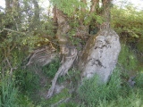
Neolithic and Bronze AgeSite Name: Murrayshall Alternative Name: Bonhard, Mill of Bonhard, New SconeCountry: Scotland County: Perth and Kinross Type: Standing Stone (Menhir)
Map Ref: NO1519926265 Landranger Map Number: 53
Latitude: 56.420954N Longitude: 3.376281W
Condition:
| 5 | Perfect |
| 4 | Almost Perfect |
| 3 | Reasonable but with some damage |
| 2 | Ruined but still recognisable as an ancient site |
| 1 | Pretty much destroyed, possibly visible as crop marks |
| 0 | No data. |
| -1 | Completely destroyed |
| 5 | Superb |
| 4 | Good |
| 3 | Ordinary |
| 2 | Not Good |
| 1 | Awful |
| 0 | No data. |
| 5 | Can be driven to, probably with disabled access |
| 4 | Short walk on a footpath |
| 3 | Requiring a bit more of a walk |
| 2 | A long walk |
| 1 | In the middle of nowhere, a nightmare to find |
| 0 | No data. |
| 5 | co-ordinates taken by GPS or official recorded co-ordinates |
| 4 | co-ordinates scaled from a detailed map |
| 3 | co-ordinates scaled from a bad map |
| 2 | co-ordinates of the nearest village |
| 1 | co-ordinates of the nearest town |
| 0 | no data |
Internal Links:
External Links:
I have visited· I would like to visit
SolarMegalith visited on 10th Aug 2017 - their rating: Cond: 4 Amb: 3 Access: 4
hamish have visited here
")
A 1.8m high standing stone which is 0.8m thick at its base.
Canmore entry.
You may be viewing yesterday's version of this page. To see the most up to date information please register for a free account.
")
")
")
")
")
")
")
")
")
")
")
Do not use the above information on other web sites or publications without permission of the contributor.
Click here to see more info for this site
Nearby sites
Key: Red: member's photo, Blue: 3rd party photo, Yellow: other image, Green: no photo - please go there and take one, Grey: site destroyed
Download sites to:
KML (Google Earth)
GPX (GPS waypoints)
CSV (Garmin/Navman)
CSV (Excel)
To unlock full downloads you need to sign up as a Contributory Member. Otherwise downloads are limited to 50 sites.
Turn off the page maps and other distractions
Nearby sites listing. In the following links * = Image available
1.1km NNE 18° Shianbank SE* Stone Circle (NO15562729)
1.1km NNE 17° Shianbank NW* Stone Circle (NO15552731)
1.9km E 100° Arnbathie Fort* Hillfort (NO1703125894)
1.9km W 275° Sandy Road East Stone Circle (NO13282646)
1.9km W 275° Sandy Road* Stone Circle (NO1327526463)
2.2km ENE 78° Shien Hill* Round Cairn (NO1735926678)
2.7km ESE 121° Commonbank* Stone Circle (NO1748824837)
2.7km ESE 121° Commonbank* Stone Row / Alignment (NO17502484)
2.9km ESE 121° Commonbank SE Stone Circle (NO177247)
3.2km SW 229° Murray Royal Hospital* Standing Stone (Menhir) (NO127242)
3.9km WNW 296° Scone Cursus Cursus (NO11712803)
4.0km WNW 294° Scone Cursus Cursus (NO11532797)
4.1km SW 232° Perth Museum and Art Gallery* Museum (NO119238)
4.1km SW 232° Inchyra* Class I Pictish Symbol Stone (NO119238)
4.7km E 96° Evelick Hill Fort* Hillfort (NO199257)
4.7km N 9° Brownies Knowe Stone Circle (NO16063092)
4.8km SW 221° South Inch, Perth Standing Stone (Menhir) (NO12002274)
4.9km N 349° Tammieteeth* Cairn (NO14403109)
4.9km NNW 342° Williamston Stone Circle (NO138310)
5.0km N 8° St. Martins* Stone Circle (NO160312)
5.4km N 7° Witches' Stone, St Martins* Standing Stone (Menhir) (NO15923160)
5.5km ENE 78° Beal Hill Stone Circle (NO206273)
5.5km NNW 348° Blackfaulds* Stone Circle (NO14133167)
5.7km NNW 331° Druids Seat* Stone Circle (NO12483132)
5.8km WNW 289° King's Stone* Standing Stone (Menhir) (NO09712828)
View more nearby sites and additional images


 We would like to know more about this location. Please feel free to add a brief description and any relevant information in your own language.
 Wir möchten mehr über diese Stätte erfahren. Bitte zögern Sie nicht, eine kurze Beschreibung und relevante Informationen in Deutsch hinzuzufügen.
 Nous aimerions en savoir encore un peu sur les lieux. S'il vous plaît n'hesitez pas à ajouter une courte description et tous les renseignements pertinents dans votre propre langue.
 Quisieramos informarnos un poco más de las lugares. No dude en añadir una breve descripción y otros datos relevantes en su propio idioma.