Register here - as a registered user you get more features and fewer ads.
Crannogs in Co. Clare, Ireland (Republic of)
1 sites recorded, with photos, maps and visitor reports
 My main expertise is of The Burren (from bhoireann meaning "stony or rocky place") in the north west of Co. Clare. It is a unique 150 square mile sweep of limestone. This most transient of rock is so vulnerable even to the mild acid of rainwater that it is being returned to the sea at the rate of half a centimetre a century. An austere landscape of wide areas of bare limestone “pavements” riven by fractures now eroded out into clefts called “grykes” down which the copious rainfall of the west of Ireland disappears leaving the land underfoot dry.
 Artificial lakeside platform chosen as a settlement site.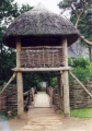
Showing 1 site in list and on map
View on Interactive Map View on 3D globe map
Site Matches - Showing 1 site in list and on map View Most Recent
Craggaunowen . Crannog in Co. Clare
Posted by Anonymous on Thursday, 15 February 2001
Accuracy: 3 (Our Pic)
We now have our own powerful Text Search which searches everything including Comments, Visit Logs and Gallery text - give it a try!