| Author | Cerrig Duon |
cerrig

Joined:
25-09-2009
Messages: 2912
from Brecon Beacons
 OFF-Line OFF-Line
|  Posted 03-10-2021 at 23:12 Posted 03-10-2021 at 23:12
Cerrig Duon and the Tawe valley, Megalithic research.
I would like to present my research on Cerrig Duon stone circle, in a similar manner to the treatment given to Maen Llia. So, I would like to keep this thread just for the research and I will start another thread for discussion, should anyone have something to say about this. All contributions are welcome, on the discussion thread, not here, please.
Please use the other thread to discuss any aspects of the main Cerrig Duon research
Cerrig Duon discussion thread
All of my original research posted here is copyrighted to me, but it is released freely under a Creative Commons License https://creativecommons.org/licenses/by-sa/4.0
You are free to use it in any way you see fit, including commercially. The only caveat is that any work that uses it or builds upon it carries the same benefits for other researchers/users, and must be attributed back to the original source.
I have a brand new discovery to add here which ties a lot of things together from the Maen Llia thread. The re is a common theme running through these sites that takes some explaining, but this new site confirms many things.
I will start with Cerrig Duon circle.
This is a plan of the circle drawn by W Grimes in the early 1960's.
diagram 1

Grimes plan was quite good, but I needed a more detailed and much larger plan so I made my own. I used the method, favoured by Aubrey Burl, of selecting two points 3 feet apart on a North/South line inside the circle, and then making a separate plan from both. They are then overlaid onto one another and compared. Any glaring errors are obvious and can be corrected easily. Between the two plans something worthwhile should show up.
I have obtained a digital copy of Alexander Thom's plan of this circle and it matches almost perfectly, so I'm happy to declare this an accurate plan, and I base some radical concepts on that accuracy.
It turns out that Cerrig Duon is not a very round circle, in any sense. Alexander Thom classified it as a class 2 egg shape, but it isn't a particularly good fit as the stones wander a bit offline all over the place.
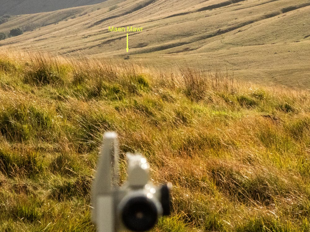
This is the circle with Maen Mawr standing stone and it's two small companions. Just to the North West is a small outlier. This little stone, about 11 inches long by 9 inches high is the key to the circle geometry.
diagram 2

Adjoining the circle from the North East is the Avenue. A higgledy piggledy collection of small stones forming two very rough converging lines which stop some 40 feet or so from the circle. Quite a few of these stones are buried and unfound by me, but most are still evident.
The stones in black are unfound today.
The three elements here, the circle, Avenue and Standing stone/row seem to be disconnected, but they are all part of a curious geometric set up.
diagram 3

Thom's plan differs from mine in a few places only. It's otherwise almost identical. I'm very pleased to say that our respective true North's matched perfectly, so you can't get any better than following A Thom on that.
True North is very important with this circle and it is evident in several places.
The differences are minor really, and mostly reflect the passage of time.
There is one stone missing from Thom's plan, on the West of the circle. It is quite small and overgrown now, so maybe it was then too, although it is shown on Grimes plan? I can't say that it appears to be important at all, but it was put there for some reason so who knows?
The outlier I mentioned previously is misaligned on Thom's plan, as he has it pointing squarely to the circle centre, whereas it points away to the East a few feet. I would say it's referencing the large gap in the South East.
The other curiosity is the fallen stone in the North East. It would appear that someone has picked it up and completely flipped it over to its present position. It is easily the biggest stone in the circle so it must have taken some doing. Oddly, in Grimes plan, the stone is shown in its present position, but overlaying the self same position on Thom's plan. I can only assume that the original impression had survived enough to leave an imprint worth noting at the time. There is just a non descript puddle there now. I would say that the stone was almost certainly standing when originally sited.
There is a stone missing from the circle now that was on Thom's plan, quite close to the centre. Grimes hasn't noted it, but I can remember it from 20 years ago. There is just a hole where it once was?
As can be seen, things change over time, so with that in mind any sort of a plan that is proposed has, by definition, to be imposed on the remains of what might have been. It's very difficult to be definite about these things. I intend to show that there was an overall scheme, and it was done on a grand scale.
This is my plan with Thom's differences in red.
diagram 4

This is Thom's type 2 egg geometry construction, faithfully copied from his original onto my plan. As you can see, its a bit of a hit and miss affair.
diagram 5

Something that Thom seemed to miss, even though his axis passes straight through it, is that the N/W outlier is in just the right place to be a corner of an equilateral triangle that neatly encloses the circle. I'm assuming he missed it because there is no reference to a triangle on his plan.
This is where the circle and Maen Mawr become entangled. When the circle diameter of 60.24 feet
(Thom made it 59.8 feet with 0.3 feet tolerance) is drawn from the outlier it lies tangent to a N/S line that grazes the Western edge of Maen Mawr. If this line is continued Southwards till it cuts the circle it will be found that this point is equi distant from Maen Mawr's S/W corner and the N/W face of the outlier, at 91.26 feet.
This position lies right next to one of the circle stones.
diagram 6

When some sizes are added things begin to get very interesting. I have spent many hours trying to find the best for this geometry, both on site and off. These truly are the sizes that work best.
The Equilateral side length of 104.24 feet is the same as the outer diameter for the Stonehenge lintel ring.
diagram 7

The Avenue, when added, fits as below. There is a position, S/E of the circle, where the centre line of the triangle and the Avenue lines converge. This point is directly due South of the Easternmost stone of the circle, and the centre line of the Avenue passes through the S/E corner of the triangle to get to it.
The converging point here is 45 feet from the circle.
Other slight variations on this may also apply. It is difficult to be precise with the rather haphazard nature of the Avenue stones.
diagram 8

Another alternative

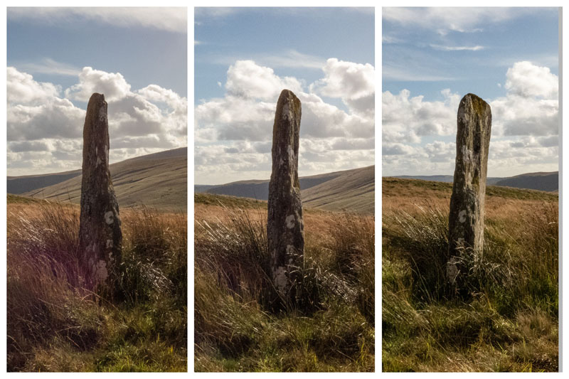
To finish this part of the Tawe valley set up it's pertinent to look at Maen Mawr and its two companions. They seem to have been very deliberately lined up. I'm inclined to believe that Maen Mawr was the last part of this puzzle to be sited, and I can only conclude that it must have been necessary to put a big old block just there for some unknown reason. It looks to me like some kind of a balancing addition, but maybe that's just me?
The view looking South. The gouge down the length of the stone is quite intriguing to me.
plate 1

The view looking East. All the measures are multiples of 3.6 inches?
plate 2

cerrig
[ This message was edited by: cerrig on 2023-03-30 15:30 ]
 Profile Profile
 Reply Reply
|
cerrig
Joined:
25-09-2009
Messages: 2912
from Brecon Beacons
OFF-Line
| Posted 04-10-2021 at 15:01
Cerrig Duon, Maen Mawr and the Avenue don't sit in isolation within the valley. There are connections to other monuments, although, because of its siting nestled in the cradle between the hills there isn't a view to any of the surrounding summits from this circle, which sets it apart from all the other Breconshire circles, who have wide open vistas?
This is looking up the Tawe valley to the North. The hill directly in front is Moel Feity and its summit is over the brow and unsighted.
The important view here is to the N/E and Bwlch y Cerrig Duon barrow. It is sited in the join between the two horizons, as shown. This is a feature that recurs all over the National park with these monuments. I'm convinced it isn't a coincidence because it is so common.
Also shown in this image is the N/S line from the Western face of Maen Mawr and the previously shown equilateral triangle centre line.
plate 3

cerrig
[ This message was edited by: cerrig on 2023-03-30 15:31 ]
Profile
Reply
|
cerrig
Joined:
25-09-2009
Messages: 2912
from Brecon Beacons
OFF-Line
| Posted 07-10-2021 at 21:45
The Equilateral triangle apex stone and it's alignment. It points to the central area of the large gap on the Eastern side of the circle.
plate 4

The same alignment to the N/W. Pointing straight at the Easternmost Compass stone.
plate 5

cerrig
[ This message was edited by: cerrig on 2023-03-30 15:33 ]
Profile
Reply
|
cerrig
Joined:
25-09-2009
Messages: 2912
from Brecon Beacons
OFF-Line
| Posted 09-10-2021 at 06:29
The Circle/Equilateral centre line. It clearly points to where the two horizons meet. Bearing here is 336.5 degrees.
plate 6

The measurement from the far side of the circle. It is showing about an inch long here because I couldn't take the picture and pull the slack out of the tape at the same time.
As can be seen the alignment goes corner to corner of the stone. This is a feature I have noticed elsewhere, notably Datum 1 stone at Maen Llia.
plate 7

View East to Maen Mawr. Set up over the stone S/E face is my faithful Ushikata transit theodolite.
plate 8

cerrig
[ This message was edited by: cerrig on 2023-03-30 15:35 ]
Profile
Reply
|
cerrig
Joined:
25-09-2009
Messages: 2912
from Brecon Beacons
OFF-Line
| Posted 09-10-2021 at 07:28
Maen Leuci
This is the view NE towards Maen Leuci. The theodolite is set up on the crest of a ridge and is inline and intervisible between Maen Mawr and Maen Leuci. This is the closest there is to a sightline between the two stones apart from a spot 1/2 mile South West of Maen Mawr.
The distance between the stones, according to Google Earth, varies between 3015 and 3025 feet. This is a close match for the distance from the circle to Waun Leuci cairns to the East.
This distance pops up in other places too!
plate 9

The same position looking South West, towards Maen Mawr.
plate 10
The view from the Equilateral triangle corner marker N/E towards the ridge along the alignment.
plate 11

This is the marker flag I erected to check the alignment. It's surprising how well it showed up, and worth all the effort of siting it because it proved crucial to finding an otherwise unknown aspect of the circle geometry.
plate 12

Curiously, the bearing of 20.5 degrees is a match for the alignment between the Henge and Maen Llia.
diagram 9

The stone centre line as determined by me, from the North, looking South West, along the alignment towards Maen Mawr ( unsighted over brow )
plate 13
The same centre line, looking North East.
plate 14

cerrig
[ This message was edited by: cerrig on 2023-03-30 15:37 ]
Profile
Reply
|
cerrig
Joined:
25-09-2009
Messages: 2912
from Brecon Beacons
OFF-Line
| Posted 10-10-2021 at 20:06
The alignment between Maen Leuci and Maen Mawr, when continued on through the circle goes through a circle stone, and on to the South West corner of the surrounding equilateral triangle, as here.
diagram 10

This alignment cuts the circle such that the chord produced is half the length of a side of the surrounding equilateral, meaning it is the whole side of a contained equilateral.
When the other two sides are added it is found that the alignment along the centre line of the surrounding equilateral corner stone point directly down one of them, as shown here.
diagram 11

The inner triangle is skewed from the outer triangle at an angle of about 44.5 degrees.
diagram 12

This is the view to Bwlch y Cerrig Duon barrow through Maen Mawr and, thanks to Harry Potter, the sorting hat stone.
plate 15

cerrig
[ This message was edited by: cerrig on 2023-03-30 15:39 ]
Profile
Reply
|
cerrig
Joined:
25-09-2009
Messages: 2912
from Brecon Beacons
OFF-Line
| Posted 11-10-2021 at 15:45
Bwlch y Cerrig Duon barrow
There are several, apparently stand alone monuments, within the upper Tawe valley.
The Cerrig Duon complex, comprising stone circle, standing stone and row, Avenue, and the Compass stones.
Waun Leuci cairns and standing stone
Maen Leuci standing stone
Quincunx
Bwlch y Cerrig Duon barrow
Bwlch y Cerrig Duon cist
There are also several cairns quite close to the Quincunx, as well as on the summits of Bannau sir Gaer to the West.
Bwlch y Cerrig Duon barrow, due to its placement directly in the dip of the pass, has some unique sightlines.
The most obvious are the major summits of Pen y Fan and Corn Ddu to the East, and Twr y Fan Foel to the West, the Equinox markers.
The central Beacons, Pen y Fan and Corn Ddu
plate 16

Bannau sir Gaer, and Twr y Fan Foel.
plate 17

These two mountain ranges are the highest in this area ( the Beacons are the highest in Southern Britain) and the barrow is sighted such that, on the day of the Equinox, the sun rises over Pen y Fan and sets over Twr y Fan Foel.
There is about 10 miles or so between the barrow and Pen y Fan, and this means that the sun or moon is a very good fit in the bowl between the two peaks, which is about 1/2 degree wide.
The angle of the slopes to the right of Twr y Fan Foel means that some years the sun will set twice on the Equinox.
The Equinox sunrise over Pen y Fan, and the rise through the bowl on the day before and after the Equinox's, neatly framing them.
diagram 13

Sunset on the Equinox's over Twr Y Fan Foel.
diagram 14

The view down the valley towards Cerrig Duon and Maen Mawr, with Maen Leuci on the left and the Quincunx down in the valley bottom close to the river.
plate 18

Zoomed in image of the circle
plate 19

Reverse view, North to the barrow, showing it's position in the notch between two horizons. A feature repeated elsewhere in the Beacons.
plate 20

The barrow itself is in a sorry state now. In several places it has been quarried, and driven over. The mound that is visible now is probably the Western half only, if that.
It does have its own driveway though, and commanding views all around.
plate 21

Some of the quarrying and traffic erosion
plate 22

There is line of sight with at least 4 stone circles. Cerrig Duon to the South, Ynys Hir 10 miles to the NNE, Banc y Celyn 19 miles to the NE and Pen y Beacon 25 miles to the E.
Rhyd Wen Fach to the West is just unsighted over the brow.
diagram 15
This is one strategically sited barrow.

cerrig
[ This message was edited by: cerrig on 2023-03-30 15:41 ]
Profile
Reply
|
cerrig
Joined:
25-09-2009
Messages: 2912
from Brecon Beacons
OFF-Line
| Posted 16-10-2021 at 20:04
Quincunx N 51.8808 W3.6690
https://www.megalithic.co.uk/article.php?sid=24942
Quincunx is the name given to a 5 stone setting, comprising a central stone with 4 outliers. Normally only found in Exmoor, this is the only one known to exist outside of that.
I found this almost 20 years ago while trying to cross the river Tawe after some heavy rain. This normally entails walking back upriver until a place can be found where the genuine threat to life has faded until its only going to be a thorough drenching. On this day the river really wanted to kill me so I trudged back to the car on an unfamiliar route and stumbled onto the Quincunx.
I didn't know what it was so I reported it to the RCAHMW, who confirmed it was a genuine prehistoric setting and it's links to Exmoor to boot. Quite a find, which generated hardly any interest whatsoever. I still haven't been interviewed about it!
This is a rough plan of it.
diagram 16

The Quincunx, looking East.
plate 23

I must admit that I find it totally baffling. I have noticed some peculiarities it has, which I will share, but what was going on here is completely beyond me.
This is the largest stone of the 5. It's the only pillar type stone, and it has been set up such that it's flattish Western face, shown here, is aligned to true North.
plate 24

The stone from above, showing it's Western face at the bottom here.
plate 25

The Northern alignment, taken against the Western face.
plate 26

The central stone, from above. A big lump, like a prop forward.
plate 27

The Southernmost stone, resembling a footprint. Probably a broken off stump now, but no sign of any other parts.
plate 28

The Westernmost stone. A semi circular leaning slab.
plate 29

The Northermost stone. Another slablike stone, with a double lean. Reminiscent of the "Hafen stone pair" There is evidence of frost damage and the stone is quite fractious.
plate 30

As can be seen, they are 5 very different stones, which I believe is significant, but I have no real idea why?
A particularly puzzling aspect of the set up is the alignment s of the stones high points. While the damage to the stones makes the North/ South alignment a little dubious there is no real doubt about the East/West alignment.
Again, I have no idea what this is about, but it repeats what was found with the Compass stones to the South, and various stones in the Llia valley.
This is the North/South alignment, looking North.
plate 31

North/ South alignment, looking East.
plate 32

The East/West alignment, looking East.
plate 33

East/West alignment, looking South
plate 34

The crossed alignments, looking East.
plate 35

The crossing position on the middle stone high point. Not quite a right angle.
plate 36

There is a little more to come for the Quincunx.
cerrig
[ This message was edited by: cerrig on 2023-03-30 15:43 ]
Profile
Reply
|
cerrig
Joined:
25-09-2009
Messages: 2912
from Brecon Beacons
OFF-Line
| Posted 21-10-2021 at 22:28
The Quincunx is part of an alignment of monuments that span the valley floor from Maen Leuci in the East to a collection of cairns just over the river to the West.
Here they are on Google Earth
Diagram 17

The view from the cairns looks like this
Plate 37

And a zoomed in view of the Quincunx from the cairns
Plate 38

cerrig
[ This message was edited by: cerrig on 2023-03-30 15:45 ]
Profile
Reply
|
cerrig
Joined:
25-09-2009
Messages: 2912
from Brecon Beacons
OFF-Line
| Posted 24-10-2021 at 11:55
Tawe valley Triangle N 51.88036 W 3.66971
This is a three stone triangular setting.
This is a new discovery, as of June 2021. Although I was aware of these stones from when I first came across the nearby Quincunx (https://coflein.gov.uk/en/site/404184 ) almost 20 years ago, I never had much confidence in their authenticity until recently.
A few months ago I had an inkling to leave my work with Maen Llia and go back to where I began my interest in megaliths, in the upper Tawe valley, specifically, the Quincunx. A monument I hadn't visited in a long time.
While I was there I had another look at these three stones, and it was only then I realised just what they really were. When I showed the Quincunx to the RCAHMW inspector in 2006 I pointed out these stones, but with very little conviction, and that seemed to be that.
These are the three stones, looking North.
Plate 39

Again, just like the Quincunx, these are three quite different stones.
This is the Corner stone. It has possibly suffered some erosion or damage to its N/W top edge, but otherwise it seems ok. It is a rectangular flattish slab, set upright and pointing approx. 150 degrees S/E.
Plate 40
Note the angle on the left edge here. It matches the corner angle of the triangular set up.
Plate 41

This is the Pillar stone. It's quite a lump, standing just under two feet tall and about the same long, with an arched profile.
Looking S/W.
Plate 42

Looking West
Plate 43

This is the Apex stone. When I saw this again, after my work with Maen Llia, it was obvious what it is, and not difficult to see why it didn't mean anything much all those years ago. Without a good grounding in Garsalian geometry (https://www.megalithic.co.uk/modules.php?op=modload&name=Forum&file=viewtopic&topic=8258&forum=4 ) it was just a curious triangular shape with no real recognised precedent to compare it with.
Now it had a meaning, and finding it as the apex stone of a triangular arrangement, whose proportions match the self same triangle, stunned me a little.
I don't see how this could be more obvious, now.
Plan view
Plate 44

Looking South.
Plate 45

Looking West
Plate 46

I thought this was astonishing enough, an example of stone age geometry that matches other sites and really confirms the findings at Maen Llia regarding the interest in this particular triangle, but that was just the start. What is a very modest monument holds all sorts of implications regarding megalithic science. When I investigated further the links to other sites started to pile up.
This is the view to the East, towards Maen Leuci standing stone ( the small black dot in the sunbeam just above the theodolite ) just under a thousand feet away, taken while undertaking some early measurements of the triangle. Maen Leuci proved to be a good reference point for the theodolite.
The actual triangular alignment passes just to the North of Maen Leuci.
Plate 47

Looking West, towards Bannau Brycheiniog.
Plate 48

Looking N/E, over the Apex stone, Pillar stone, and onto Bwlch y Cerrig Duon barrow.
Plate 49

Lookin South from the Corner stone, over the Apex stone. The theodolite is set up precisely over the N/W corner of the Corner stone here. This is the Datum point of the surveys.
Plate 50

An image taken through the pillars of the theodolite, showing the view South, grazing the Western edge of the Apex stone and on to Maen Mawr standing stone and Cerrig Duon stone circle.
Plate 51

Every leg of the triangle is pointing towards another monument within the valley. Those relationships are telling the same story as found in the Llia valley. The builders here were investigating the same geometry and the self same Garsalian triangle.
cerrig
[ This message was edited by: cerrig on 2023-03-30 15:47 ]
Profile
Reply
|
cerrig
Joined:
25-09-2009
Messages: 2912
from Brecon Beacons
OFF-Line
| Posted 24-10-2021 at 15:55
The triangle identified within these stones is determined by the N/W corners of each stone. This gives a triangle of 50.34 ft x 54 ft x 19.8 ft, with angles of 21.47 degs, 68.53 degs and 90 degs.
This is the Garsalian triangle, sized to fit the Stonehenge sarsen ring mid diameter and its Bluestone Horseshoe mid diameter, as identified at Rhyd Uchaf cairn in the Llia valley. It's the same triangle!
Here is the plan of the Tawe Valley Triangle.
Diagram 18

This is the geometry of the Apex stone
Diagram 19

This is how that triangle fits Stonehenge
Diagram 20

The Tawe valley Triangle would fit like this, size for size.
Diagram 21

The distances from the Triangle to the other monuments is also linking this to other important sites.
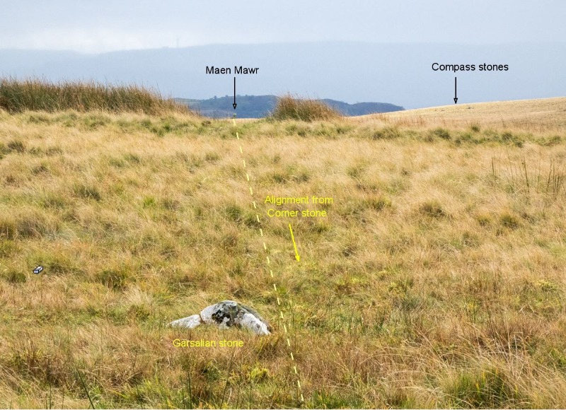
The alignment from the Corner stone past the Apex stone Western edge would graze the Eastern face of Maen Mawr and cut the Cerrig Duon circle diameter at a point right next to a stone on its Southern arc, as here.
Diagram 22

The alignment looks like this
Plate 52

A bit closer its like this
Plate 53
The distance from the Corner stone to the point where it cuts the southern arc of the circle diameter is 3020 feet, according to Google Earth. This is 60 x the 50.34 feet length of the Triangle leg that is part of that alignment.
Diagram 23

The distance from the Apex stone to Bwlch y Cerrig Duon barrow is about the same. The barrow is rather a damaged and an indistinct feature so there is no actual position that can be pointed at, just that the alignment grazes the Western edge, as seen here.
Diagram 24

This is where the Triangle sits within the upper Tawe valley and its monuments.
Diagram 25

Something to note here is that the leg that is aligned with Bwlch y Cerrig Duon barrow is 54 feet long, and 56 of those is 3024 feet, which is also a good fit for the barrow distance.
These are particularly curious measurements. I'm sure a lot of the researchers on the Portal will recognise that 3024 feet is the distance around the base of the Great pyramid of Giza, 4 x 756 feet( per side)
The leg lengths of the Triangle, 50.34 ft + 54 ft = 104.34 ft, the side lengths of the equilateral triangle that surround Cerrig Duon circle.
The distance to Maen Leuci is the same as the centre line distance from the midpoint recumbent at Maen Llia to Rhyd Uchaf cairn.
Another curiosity is that, if the true North bearing from the point where the southern arc of Cerrig Duon is cut by the aforementioned alignment is followed North back to the region of the triangle, a 60/30 triangle constructed using the divergent bearings would work out with sides of 90.36 ft x 52.17 ft x 104.34 ft, which are the principal dimensions of the Cerrig Duon geometric scheme.
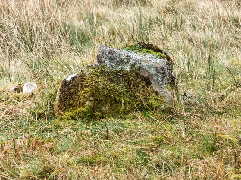
Just to the side of the Corner stone is another small set stone. This stones Northern edge is 52.17 feet from the Apex stone N/W corner position.
Plate 54

All in all, quite a lot from 3 rather anonymous stones. The implications here are challenging a lot of my thoughts on the capabilities of the builders and their technology, as well as confirming my belief that most of this was beyond them. It is certainly beyond me because I still have no idea what they were doing?
cerrig
[ This message was edited by: cerrig on 2023-03-30 15:48 ]
Profile
Reply
|
|

