The cairn, or what's left of it. Looking North West, towards Maen llia.
Rhyd uchaf cairn is the only one of the major monuments to be sited at the pinnacle of a purely natural feature. It sits squarely on the summit of a low domed hill, so it would seem to be the original Datum point of the major triangular layouts. If this were so it would be truly remarkable, because everything else would have to have been arranged to suit the cairn placement.
This would have been, I believe, an impossible task, given the complexity of what's to come. The question that's raised here is this; where was the initial "anchor point" of the geometry?
It's as though a huge plan has been dropped onto the landscape, pinned at the cairn and spun around that point until it sort of fitted the major monuments, and then everything else has been added to suit that. Except, that wouldn't explain the precise siting of Maen Llia to work as the calendar device.
Maen Llia is in the only position it could be in for all its effects to work properly, even given that it needed a moulded platform to carry them off. It's sighting is still dependant upon the valley and the surrounding hills making the effects possible at all.
There is something quite out of the ordinary about that conundrum!!
Rhyd uchaf cairn, or at least its barely visible ruins, sat on its pinnacle. In the foreground is Angies Lake, home to the Water Sprite.
Captured on a misty Equinox morning.
In this google earth image of Rhyd Uchaf cairn can be seen the cairn and it's lonely outlier. This stone sits about a foot tall and 3 1/2 feet long with a noticeably pointed profile, aimed to the East of Maen Llia. This is one of a group of pointed stones that are scattered around the valley bottom.
It seems to be randomly placed but a long investigation has turned up what seems to be something a bit special going on here.
The outlier, with Rhyd uchaf cairn just behind it. Note the pointed shape.
Earlier in this thread I detailed how I chanced upon the geometry that defines the triangular set up using compass and straight edge techniques. This is the particular construction that got things rolling.
It begins with the baseline and circle joining Maen Llia and the Henge, then the vesica arcs that give the centre line. Where the baseline circle cuts the centre line is the centre of the largest circle that defines the Cairn's outer diameter, and where the vesica arcs cut the centre line is the centre of the circle that defines the centre of the cairn, as shown here.
here
This is how those arcs look in close up with the triangle centre line. The key here is the point where the large arc cuts the triangle centre line to define the outer diameter of the cairn.
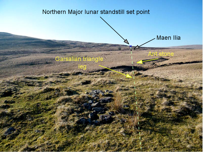
It is when the Garsalian triangle geometry is added that the position of the cairn outlier stone begins to make a bit more sense. It has been sited at precisely 60 degrees from the arc intersection, and 50.4 feet away. This is the same distance from the intersection as the Garsalian triangle apex.
When the legs of the Garsalian triangle are added it looks like this.
This is the resulting equilateral triangle formed inside the circle. Continuing with the sqrt 3 theme that is central to the Garsalian triangle the equilateral circumcircle radius of 50.4 ft and the triangle side lengths of 87.3ft also have a sqrt 3 relationship (1.732)
This is the view from the triangle apex back to Maen Llia.
While the placement of the cairn outlier/equilateral stone is, I believe, very strong corroboration for the general geometric theme of the valley, what follows is what seems to be more corroboration of a widespread geometric theme that includes Stonehenge.
The 50.4 feet radius marked by the outlier stone will be familiar to other researchers as the midpoint of the Sarsen ring diameter at Stonehenge, as I have pointed out before regarding Rhyd Uchaf cairn.
This is Alexander Thoms plan of the Sarsen ring at Stonehenge. I have overlain an equilateral triangle inside the circle using the centre line of the monument as one of the altitudes of the triangle.
What is remarkable about this is that when the arrangement from Rhyd Uchaf is overlain onto the Thom plan, preserving the relevant compass alignments, it is a near perfect fit, (depending on which particular Stonehenge centre line is preferred).
When the geometry of Stonehenge is overlaid onto Rhyd Uchaf cairn the position of the cairn outlier stone places it slap bang in the centre of the sarsen lintel ring, with its dimensions matching the width of the lintels.
The equilateral geometry and how it relates to the cairn and the Garsalian triangle apex. My bag takes the place of the equilateral centre point here ( also the apex of the 45 degree triangle )
Everything is connected in one grand scheme
[ This message was edited by: cerrig on 2023-04-17 14:46 ]
The "Henge" is completely overgrown with Bilberries and grass. It's almost invisible until you are right on top of it. Due to natural erosion and slumping the banking's are undoubtedly lower than originally built and the ditches not as deep. This has softened the profile of the henge, but as with the other monuments it has mostly survived to be reasonably intact.
It is sited on the Western side of the Llia valley, on a gentle slope.
This is a Google Earth view of the Henge.
It consists of a flattish central circular area, about 20 feet in diameter, with two concentric banks and ditches outside that, with just a hint of a third banking beyond those. There is a gap in the banking's on the Eastern side.
Within this are two smallish set stones. One in the central area and one in the outer banking. These stones form an East/West alignment following the leg of the triangle layouts.
These two stones are about 30 feet or so apart.
The centre stone.
The outer banking stone, showing the tape measurement from the centre stone.
The alignment goes directly to Rhyd uchaf cairn. As with the 62 degree line alignment, the two stones here are also in a "lazer" alignment to the centre of Rhyd uchaf cairn.
I once cleared the grass from around the stones such that they were visible from the cairn, with binoculars. Stood up in the cairn both were visible, but when I lay down the outer banking stone completely hid the centre stone.
Profile of the alignment
In the other direction the same alignment goes to Lexi's lookout, about 250 feet further up the hill.
Plan view of the alignment.
There would appear to be a connection in the triangular layout mirrored by an actual alignment of Rhyd uchaf cairn centre, the Henge outer banking and centre stones, and Lexi's lookout stone.
Another connection would be the distance between the henge stones and the distance between Rhyd uchaf cairn centre and the Garsalian triangle apex, 30.6 feet.
The corresponding sizes of the henge and the cairn also match. The outer diameter of the cairn is 39.6 feet, and the outer diameter of the henge's first banking, where it would have met the original ground level, about half way to the ditch bottom, is also 39.6 feet.
These cairn and henge measurements are obviously imposed on the now much denuded remains, but they are a very good match when the plan views are overlain.
The profiles of the different monuments, when compared, show just how similar they are.
The Henge is shown in its South to North profile. It is actually somewhat oval in the West/East direction, so I've taken the liberty of showing the outer banking stone in its correct relationship with the centre stone. This is to compare it with the triangle apex position at the cairn.
With this caveat, and the cairn shown in its West/East profile, you can see that these two could be twins. If the cairn was covered in Bilberries they would be.
Another connection is the opening in the Northern arc of the cairn, mirroring much the same characteristic in the Eastern arc of the Henge that points towards the cairn. The cairn opening points towards the low hill that is also the target of Datum stone 1.
I now call this hill Megan's mound.
[ This message was edited by: cerrig on 2023-04-05 11:21 ]
Rhonwens row. The yellow flag marks the closest stone to Maen Llia.
Plan view of Rhonwens row, showing the distances from Maen llia's Northern face. The stones are all rough slabs, with their Eastern faces aligned.
The unworked coarseness of the stones would imply that they were probably some of the first markers used in the valley, along with Runes stone. So, Maen llia would have been lined up with these and not the other way around.
The layout of Maen Llia, Rhonwens row and Runes stone.
Rune's stone is at 90 degrees to the greater Garsalian triangle baseline relative to Maen Llia, and it is also the same distance from Maen Llia's Northern corner point as the most Southerly exposed stone in the recumbent stone row.
The arrangement turns out to be a precise Garsalian triangle, with the Garsalian leg serving as its centre line.
Plan view of the geometry overlaid onto Maen Llia.
When a bit more of the geometry is added the new Garsalian fits the original triangle like this.
A bit more investigation reveals the Maen Llia, stone row and Rune's stone triangle (now known as Rune's triangle) to be part of a larger construction, as is the norm. The stone row picks out various intersections within this larger construction, and the corner stone for Runes triangle becomes the circumcentre for the new larger triangle.
Also note how the bottom left corner of the new triangle lands precisely on the fence line of the road. This is too common an occurrence for the road footprint to be anything other than to be built upon an underlying pattern.
The alignment from Maen Llia to the stone row, when extended, passes through the circumcentre of the greater Garsalian triangle, as shown here.
There are some particular properties of the Garsalian triangle that show up in the "Rhonwens row" geometry that are important in understanding how the stones are laid out. One of the most fundamental aspects of the layout is that none of the stones have a singular role. They all link different patterns to one another, with much being implied from very few stone markers.
After some remeasuring of Rune's triangle, the angles have been confirmed with a new calibrated and certificated theodolite and the length's likewise confirmed with a steel survey tape. The result is quite remarkable. Rune's triangle( named after Runemage ) is a multifaceted affair. The most obvious characteristic of it is that it is a precise Garsalian triangle, and it holds within its dimensions a precise 1/5th scale size of the greater Garsalian triangle that it interacts with, as shown below.
This is how Rune's triangle is situated within the Llia valley complex. As can be seen, it is found in the northern corner of the larger triangle. Both triangles have exactly the same proportions, and the centre line of Runes triangle is also the leg of the greater triangle.
The length of Rune's triangle's centre line, which lies along the greater Garsalian's longest edge, at 1081.87 ft, is precisely 1/5th of that edge's length at 216.37 ft.
This is how that looks.
When the length of 216.37 ft is used as the long edge of a Garsalian it fits inside the greater Garsalian exactly 25 times, as shown here.
This is how Rune's triangle, it's sibling, and the slightly larger member of the family shown in an earlier post fit together. As can be seen, the smaller triangle fits into the larger here 4 times.
These are some measurements taken along the baseline from Maen Llia to the centre stone of the Henge, taking in various markers along the way, namely large stones and the dry stone wall and road fences. All of these, I believe, to be either genuine ancient markers, or built upon ancient markers.
These are all canonical measures, as were the earlier measures shown on this thread. This is a feature of this site.
More of the same.
This is Rune's triangle one last time, and the stone row. Since I discovered the row I believe it is my right to name it, and as such I am rejecting the completely unrelated name of Rhyd Uchaf and replacing it with "Rhonwen's row" in honour of my daughter, who has spent many a happy hour indulging me in my quest to measure and make sense of this place, carrying tripods and bags, and even learning how to use a theodolite in the process.
I believe that Rhonwen's row is possibly the most telling and most mysterious marker in the whole site, a bit like my daughter.
This now meant that the Garsalian triangle was laid out, very accurately, on the ground, over a huge footprint, three times, with stone markers at every corner. There could be no doubt that this triangle was most definitely being investigated by the monument builders.
[ This message was edited by: cerrig on 2024-11-16 12:22 ]
Posted 22-04-2020 at 15:14
The late and great John Michell, who wrote many excellent books on the subject, discovered a fascinating relationship between the Earth, Moon and geometry. He called this his "Heavenly diagram".
This is a version of Johns diagram. It shows the Canonical values ( another of Johns discoveries) for the Earth and Moon dimensions when they are placed next to each other. The triangle in the centre is a very good match for the great pyramid of Giza.
When the new Llia valley triangle, which I have named the Garsalian triangle, is applied to John's diagram it fits like this. It's almost a perfect fit, with a very important difference, which I will get to later.
This is how the Garsalian triangle fits the Stonehenge lintel ring.
And how its circumcircle and inner circle fits the ring and Aubrey holes. The ratio is 2.732: 1, or sqrt 3 + 1: 1.
cerrig
[ This message was edited by: cerrig on 2023-03-20 11:42 ]
Posted 22-04-2020 at 15:25
This would be a huge coincidence if it wasn't for the dimensions of the Garsalian triangle in the Llia valley. As can be seen in the Stonehenge lintel version the inner Bluestone horseshoe is a very good fit for a circle of 39.6 feet diameter, and the Bluestone circle is a very good fit for 79.2 feet diameter. ( Again, courtesy of John Michell for these insights )
John's "heavenly diagram" uses the canonical Earth measure of 7920 miles, the baseline of the Llia valley Garsalian triangle is 792 imperial British feet long.
When John Michells Heavenly diagram is overlaid onto the Llia valley map it fits like this.
The Llia valley triangle is a living model of John Michell's Earth/Moon diagram at a scale of 1 foot to 10 miles, or 20 times bigger than Stonehenge.
Much more can be found on John's "Canonical system", the "new Jerusalem" and the "heavenly diagram" in his books. I would thoroughly recommend them.
The layout of the Llia valley monuments is a genuine representation of John's Heavenly diagram, and would appear to confirm his work.
cerrig
[ This message was edited by: cerrig on 2023-05-04 17:37 ]
Posted 22-04-2020 at 15:43
When the heavenly diagram is overlaid onto Rhyd Uchaf cairn and its horseshoe attachment things began to slot into place. God bless John Michell and his magical thinking, without it I would never have looked at this.
This is Rhyd Uchaf cairn, and the horseshoe, and this is how it works when the Garsalian triangle is overlaid and dimensioned.
When these distances are added together some curious things showup.
All of them together comes to 198 feet, or 10 times the circle radius, or 1/2 the Llia triangle baseline length of 792 feet. Stonehenge is a 1/20th scale partner to this arrangement. Same design, different version.
Now things are in a real pickle. How to reconcile all this with the accepted history of the time and the technology available to the megalith builders. It just doesn't square at all.
[ This message was edited by: cerrig on 2023-04-11 09:37 ]
A curious aspect of the Llia valley site and it's relationships with Stonehenge and the Great pyramid shows up in the metrology, specifically the Canonical metrology.
This is the "static grid" I have talked about before. The Energetic framework that the "dynamic grid" hangs on. The static grid is mostly, but not exclusively, rigid and unmoving. It is constant and stable, whereas the dynamic grid is almost always trying to escape its bonds and its a bit like a puppy on a lead. The connection between the grids being the lead.
When the Garsalian triangle is applied to Stonehenge in a Canonical way, with the baseline circle of 39.6 feet overlaid onto the Bluestone horseshoe, the height of the triangle is 50.33952 feet. The mid diameter of the Sarsen ring is 100.8 feet, or 50.4 feet radius. This gives a difference of 0.06048 feet, or .72576 inches ( 18.434 mm )
Over the diameter this would be 0.12096 feet, 1.45152 inches ( 36.868 mm )
When this is compared to the Llia valley Garsalian the difference is 20 times that of stonehenge, or 1.2096 feet.
The Canonical "standard" would be 1008 feet, and when 1.2096 is divided into 1008 it comes out at 833.333 units. This is obviously a third of a bigger number, so multiplying it by 3 gives 2500 units in 3024 feet.
This is very curious, because 3024 feet, 4 x 756 feet, is the distance around all four sides of the Great pyramid, as shown here.
There is some dispute regarding the true length of the GP's sides, with a variation in measurement of a few inches between them. A popular figure is about 755.8 feet. This gives a perimeter of 3023.12 feet, or the same length as half a second of latitude at the equator.
The unit of difference in the Llia valley, 1.2096 feet, is already known as an ancient measure, the Canonical Roman Remen ( John Neal, All Done With Mirrors )
The Remen is made up of 20 "digits", of 0.06048 feet, the Stonehenge difference unit.
There are 12096 inches in 1008 feet?
There are 1,296,000 arc seconds in 360 degrees?
T
Another link to Stonehenge is the Altar stone which has been identified as coming from the Senni beds. The Senni valley, from which the beds got their name, is visible from and lies just over 1000 feet to the North of Maen Llia, and the quarry that Maen Llia possibly came from overlooks it, so the source of the Altar stone could possibly be right here on Maen Llia's doorstep.
Might it have come from here because this place was so special at that time?
This is a link to the latest geological study of the Stonehenge debris relating to the Altar stone, from Rob Ixer.
About 250 feet South East from Maen Llia, sat right next to the alignment between Maen Llia and Rhyd Uchaf cairn, is the Lozenge stone and, the other side of the line, is its companions, the 43 degree stones.
Here they are, looking North West towards Maen Llia.
This is the Lozenge stone. It's a curious mixture of a lozenge shaped pyramid. It is about 9 inches tall and 11 inches per side at ground level, but the original soil line is unknown and the sloping sides mean it could have been intended to be smaller or larger, or maybe it never really mattered?
Because the Lozenge stone is a regular geometric shape I was able to make a fibreboard cut out to fit over it, and this is how that looks in relation to it's neighbour.
The actual lozenge turns out to be this shape, which is a double Garsalian triangle with a central divider strip.
This is a little more of the geometry that goes with it. There is far more to it than this but you get the idea.
It might seem like a random shape that I've chosen to fit previous geometry, but it's not. The shape is the perfect one for this position in the overall scheme because of how it fits into the other already identified markers.
The most obvious clue to this is the Split stone, seen here with a tape laid out towards the Lozenge stone.
When the tape is straightened out and laid next to the Lozenge stone, overlaying the fibreboard, it looks like this, a perfect fit for the Eastern edge of the Lozenge stone.
The Lozenge stone is aligned East/West.
The same fit is found with a tape stretched from Runes stone, as here. Compare it to the diagram on the left of the fibreboard.
The same fit is also true of various other markers in the vicinity, all showing up various aspects of the triangle geometry, as seen marked on the board.
The 43 degree stones, sat on the other side of the greater Garsalian leg, is another oddity. The two stones have been set at an accurate 43 degree spread, displaying a practical knowledge of the site geometry.
The angle formed at ground level was measured quite accurately using this contraption, which happily fitted snugly into the notch of the left hand stone, which proves conclusively that B&Q really is prehistoric. (other stores are available but they don't sell these)
The scale reading confirms the 43 degree angle. This was a real surprise and a real mystery. There can't really be any denying the obvious links to the site geometry here, and in 3 dimensions to boot. What these stones are doing I have no idea, but this position is defined by this lozenge shape within the overall geometric scheme, and it has been marked in an emphatic and unique manner.
There is no doubt in my mind that these are deliberate man made 3D representations of the Garsalian triangle, sited to emphasise their special place within the overall site.
This is how the Lozenge stone and its partner fit into the site geometry. They occupy the point where Rune's triangle circumcircle cuts the Greater Garsalian leg, as below.
This is not a random position. When the geometry is expanded it proves to be the Orthocentre of a mirrored "Rune's triangle".
This has already been referenced in the plan view of the Lozenge stone, with the alignment from Rune's stone, as shown earlier in this section.
The geometry that comes from this can and does get very complex, which is a bit off putting, so I won't go any further here. It is self evident now that this triangle, the Garsalian, was being studied and explored, on a grand scale.
[ This message was edited by: cerrig on 2023-05-02 14:25 ]
Up till now the main emphasis has been on Geometry, shadows and the Sun. This has shown how the designers and builders of this remarkable site have blended these elements into an elegant year long performance of the calendar, celebrating their widespread skills and artistry in a very Neolithic way. Quite a feat, but that is only the encore.
There is a much more profound statement being made here. Almost as though a proclamation that the pinnacle of scientific endeavour has been reached. It must have seemed so at the time.
The Moon is a very complicated timekeeper, and I must admit it has been sadly neglected in this study, but maybe there was a need for some other pieces to slot into place before it could truly be accounted for. It would have made very little sense on its own.
Alexander Thom took some time before he latched fully onto the implications of Lunar observations, but then he was away and flying with some baffling explanations for the moon's movements and mans attempts to pin them down. His book "Megalithic Lunar Observatories" is not a casual read, and I don't recommend it as an introduction to Lunar understandings. Most attempts at describing the Moon, by just about everyone I've come across, drift into murky waters somewhere, it's that kind of a phenomena.
In the Llia valley the Moon, despite its uncooperative tendencies, has also been incorporated into the geometric layout, in an emphatic, uncompromising and undeniable way.
This is how that looks
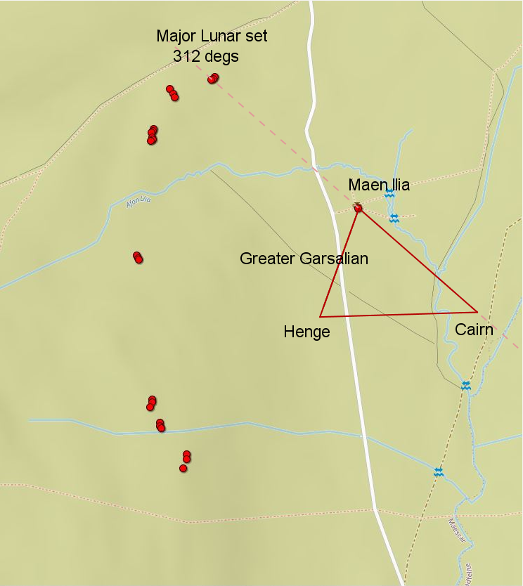
Here are, once again , the Garsalian triangles, all marked out by set stones on the corners of the triangles.
This was the first to show up. I call this the Greater Garsalian. All three of the major monuments marking its position.
Next was the Henge corner Garsalian, with the Altitude stone and the Baseline recumbent joining with the Henge to mark this one.
These have been joined by Rune's triangle, which sits with Maen llia as it's apex. This is the one I am mostly investigating here.
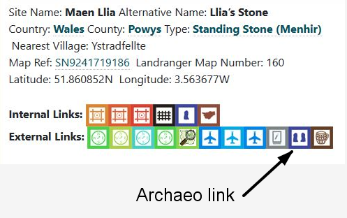
Something I never realised, until I used a tool provided here, on the Portal, on some site pages. There is an Archaeoastronomy option for the site. It's one of the buttons found under the site description, as here.
Clicking on that button takes you to David Hoyle's website, straight to a page just for the same site you were looking at on the Portal. This page has an horizon profile for the site with the various Sun/Moon paths plotted on it, with a compass scale. Very informative.
On the top of the page is a toolbar with options for date and scale etc, and a map option which gives a Google Earth style view, with all the horizon positions plotted for you. It's Childs play to use, and it was eye opening to me.
This is the plot for Maen llia's Western set positions
The profound statement that I mentioned earlier comes to life when the Geometry of the Garsalian triangles is compared to David Hoyle's horizon plots.
This is something that was first pointed out to me by Archastro some time ago. It has taken till now for the fuller picture to emerge, but that's generally how these things go.
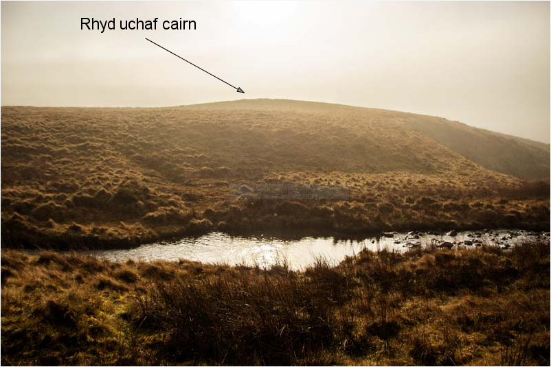
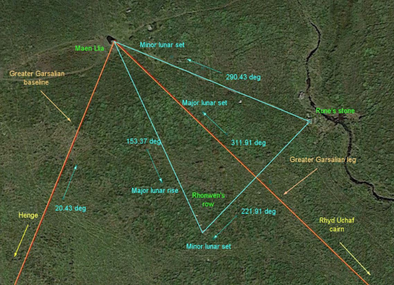
The leg of the Greater Garsalian from Rhyd uchaf cairn to Maen llia follows a bearing of 311.92 degrees, which is a match for the Major Lunar standstill set position.
This is the alignment viewed from Rhyd uchaf cairn. In 3000BC the Northern Major lunar standstill moon would have set directly above Maen llia.
View of Major Lunar standstill North setting behind Maen Llia, as viewed from Rhyd Uchaf cairn. Oct 21/ 2024.
The leg of the Greater Garsalian is also the centre line of Rune's triangle. When the sides of Rune's triangle are compared to the horizon plots then the profoundness ramps up a fair bit.
All of the sides, and the centre line, point to horizon setting or rising positions of the Lunar standstills, all of them, Major and minor, North and South.
In one triangle the entire range of possibilities are covered.
This cannot possibly be a coincidence, and it is surely absolute proof, given that the geometry and the astronomy define each other here in an impossibly definite way, that both the geometry and the Astronomy were being studied, in the Llia valley, in 3000BC, by stone age geniuses.
In light of this I am renaming Rune's triangle the "Mune triangle"
[ This message was edited by: cerrig on 2024-10-21 18:36 ]
Posted 26-04-2020 at 14:46
Another odd feature of the site is its Egyptian connections, specifically similarities between the Great pyramid design and angles and dimensions of the Llia valley design.
As with Stonehenge there seems to be a common underlying design that is expressed differently at different locations. A kind of local preference?
Maen Llia itself shares the slope angle of the GP with its North celestial pole pointing edge, as here. Curious that this stone is sited at a latitude that is a very close match with the GP slope angle, 51.86 degrees North.
There is also an oddity with the GP base size and the triangular layout here. The GP has sides of 756 feet at the base, this forms a square with a diagonal of 1069 feet. If arcs are drawn with the diagonals as the radii they would meet 1000 feet from the baseline, as here
When this is overlaid onto the Llia valley map the intersection of these arcs occurs just beyond Rhyd Uchaf cairn. The corner of the GP would sit on top of the first crest of the henge, 18 feet from its centre.
Another curiosity is the triangle that is formed when the apex of the GP diagonals arcs intersection and the Garsalian triangle baseline corners are combined. The angles produced are about as canonical as you can get.
The difference in the sizes of the Gp side length and the triangle baseline is 36 feet, and both lengths are multiples of this, 756 = 21 x 36 and 792 is 22 x 36. This is a number that repeats constantly in the Llia valley.
The GP is believed to have been designed to have a side length of 440 Egyptian cubits of 1.71818 feet, the Llia valley baseline would have a cubit of 1.8 feet if divided by 440. I.8 feet is another unit that repeats constantly. The outer diameter of Rhyd Uchaf cairn at 39.6 feet would have 22 x 1.8 feet cubits, echoing the 22 x 36 feet divisions of the 792 feet baseline.
1.8 feet is 21.6 inches, a Canonical number.
Another curious link to Egypt is this engraved stone, the Llywel stone, now in the British museum. It was found local to Maen Llia, but its original location or meaning is not known. The pyramid shape is unmistakable.
cerrig
[ This message was edited by: cerrig on 2023-06-12 12:07 ]
During my investigation of the Llia valley monuments and their layout a special triangle showed up. I have called this triangle the "Garsalian" and the associated geometry that it displays I have also called "Garsalian geometry". This naming is mostly for my own benefit as a means of distinguishing it from other forms of geometry, the most relevant would probably be "Sacred geometry". There is plenty of overlap between them, and probably any form of "Euclidean" geometry too.
I am not claiming a new kind of geometry, just a different style of use. I didn't go looking for this. I was quite content to apply Sacred geometry where I could, but it didn't quite fit, and then the Garsalian triangle turned up, quite unexpectedly, completely out of the blue.
Lots of "things" have turned up "out of the blue" during my explorations in the Llia valley.
I have already shown how the Garsalian triangle first came to light. This section I am devoting to some of the properties of the triangle, just to show how special it is. A book could be written all about this triangle and its properties, which begs the questions, once again, why was it being investigated by Neolithic people, and why hasn't anyone, even those amongst the worlds great mathematicians, noticed its existence since?
Where did that knowledge go in the meantime?
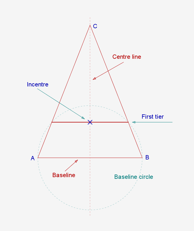
The basics of Garsalian geometry can be boiled down to just a few elements and their relationships. Centred around Isosceles triangles and their baseline circles, as shown here.
The points where the baseline circle cuts the triangle legs forms the First tier and the baseline of the new First tier triangle. This triangle comes up again and again.
This is the basic triangle.
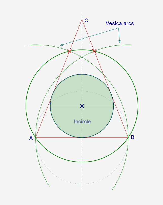
Where the first tier line, shown here, cuts the centre line is the Incentre. This is the only triangle that has this property.
A circle drawn from the Incentre such that it passes through the baseline corners cuts through the triangle legs at the same intersections as the original Vesica Piscis. Another unique property.
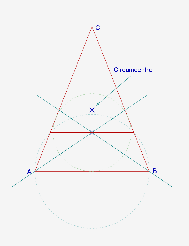
To find the Circumcentre, draw lines from both baseline corners through the Incentre and on through the triangle legs. Then join these intersections. Where this line cuts the centre line is the Circumcentre. There are other methods to find the circumcentre, but this one only works with this triangle.
The Circumcircle inner circles, shown here, have the unique property of sharing their diameter with the height to the Circumcentre from the baseline.
There are other first tier triangles formed by circles other than the baseline circles. The Garsalian triangle has some unique properties relating to these various tiered triangles that don't exist with other Isosceles triangles, which have their own relationships, but none like these.
The first tier triangle shown above is formed by the baseline circle centred on the baseline, or the definer circle centred on the triangle corner. The definer circle forms another Garsalian triangle within itself, as shown.
When the definer circle is leapfrogged up the triangle leg as shown it is found that it can be stepped off 3 times, leaving a gap at the top of the leg. This gap is exactly equal to the first tier triangle for the Garsalian formed inside the definer circle on the baseline. Only the Garsalian has this property.
Another form of tier comes from centreing the baseline circle on the corner and leapfrogging that up the leg, as shown.
This produces another gap at the top and another first tier triangle that exactly fits the baseline circle Garsalian, as per the previous definer Garsalian.
A slightly different form of tier is achieved by the Circumcircle inner circle leapfrogging up the vertical centreline and perpendiculars radiating outwards from these points to cut the legs. The resulting tiers produce the same first tier triangle relationships as the previous examples. There is much more going on here as this drawing hints at.
[ This message was edited by: cerrig on 2023-05-27 18:19 ]
Something that keeps on recurring in multiple ways is the concept of the first tier and its associated triangle within a triangle. The Garsalian triangle, above all others, uses this constantly. The first tier is an important element is the recumbent stone row, Rhonwens row.
This is a comparison of the first tier triangle and the triangle it came from.
I'm using my usual convention of ratio's for the lengths, with the baseline being equal to 1. As can be seen here this gives some interesting ratios, and the link between this triangle and the vesica piscis is shown in the sqrt 3( 1.73205 ) showing up all over the place. The first tier baseline length being sqrt 3 - 1 = 0.732.
When the differences in lengths between the full size and first tier triangles are compared the ratio is 1.366 : 1 . ( 1/ 0.732 )
When the areas are compared its 1.866 : 1 .( 0.6356 / 0.3406 )
Curiously, 1.866 / 1.366 = 1.366?
Another important element in Rhonwens row (extended) is the incircle. This defines the position of the "Dor stones" by it's tangent point with the leg of the greater Garsalian. This position is always precisely half the length of the baseline, (or the radius of the basline circle) so using ratios will give you the lengths of all the other components of a Garsalian triangle from knowing this one distance. The main problem is deciding which is the relevant length because of the uncertainties of the end points, a feature of investigating rough stones. I have come to the conclusion that there is a range of possibilities available, and they probably all apply. I tend to link these to known prehistoric features in order to give some context, but this is just a guide.
The image below shows various ways of finding the incentre, namely; bisecting the triangle corner angles, where they meet, on the centreline, is the incentre; drawing an arc with its centre on one of the baseline corners, equal to the baseline circle radius, that cuts the leg and then constructing a right angle from that point to cut the centre line, this is the incentre; In the case of a Garsalian, and only a Garsalian, where the first tier line cuts the centre line is the incentre, and it can also be found, only in the Garsalian, by joining the "pivot point" to one of the baseline corners. There are other ways too.
The incircle tangent point is the baseline centre of a small Garsalian when joined to the incentre, as shown here. When this centreline is extended it cuts the left hand base tier leg precisely half way between the first tier point and the corner. Again, this is only true with the Garsalian.
As can be seen, there is another correlation between lengths and areas with the incircle radius and the the first tier triangle area?
When the smaller Garsalian is replicated, as shown, it is found to be a first tier triangle of its own, defined by the full size Garsalian. Expanding and developing the geometry in this way is the essence of Garsalian geometry, and as can be seen there are numerous other Garsalian triangles evident in this diagram, just by extending existing lines. This process has no end.
The problem with this is deciding which direction to follow. This is just one of an infinite number of options that could have been taken here.
Just to show an example of an expansion, these Garsalians share the same first tier line in a way defined by the previous diagram, and the ratio between them is, again, 1.366 : 1.
[ This message was edited by: cerrig on 2023-04-10 12:46 ]
I will try and make this as painless as I can for all for those who don't like maths but who want to learn a bit more about this. Unfortunately for those same people geometry was still geometry thousands of years ago, so it will all look depressingly similar, but while there is nothing new here in the subject what is new is the way it has been used and marked out on the ground.
Somewhere here there is a point where human endeavour and human investigation meet. A major part of my interest is finding where that point lies. I'm still looking?
The geometry that can be found in the Garsalian triangle is the main reason that I can't link the original triangular patterns to a human invention, but rather it seems to me that it can only be down to human investigation of a detectable phenomena. I don't know what this could consist of or how it was detected, but after years of trying to make the human made theory match I finally had to give up when the depth of the geometry and the way it was marked out on the ground made that theory unsustainable.
Below are examples of the Garsalian triangle geometry. This is a very small sample of it and it mainly shows some basic properties of the geometry and how it works and builds. The fractal nature of it is the killer for a human involvement from 5000 years ago.
This is the first method of drawing the triangle I ever came across. As can be seen here it is intimately tied to the Vesica Piscis.
The sequence of construction follows the letters, from drawing a circle AB on the line, then arcs BC and CB, forming the Vesica. The vertical line is drawn through A and D, and then the most important circle within the whole "style"of Garsalian geometry is drawn. This circle, which I call the "definer", opened up the whole can of worms when I moved it to the corner of the triangle, as shown, and then drew a line from the corner B through the intersection F to cut the centre line at G. This formed the first Garsalian triangle seen for thousands of years, if my research into geometry is correct that is, and the field is so vast that I can't really be certain of that, but I believe it is correct. Time will tell.
This is another way of drawing it. Using the same method but this time instead of transferring the circle a line is drawn through intersection D until it cuts the definer circle at F, the distance BF is the radius for the arc that cuts the centre line at G.
Here's another method. The same line/circle/vesica arcs construction is followed as before, this is the basis for all garsalian geometry. The centre line is extended down to F. Another vesica arc is drawn from F through E to cut the baseline at G. Another arc, centre C radius CG is drawn up to cut the centre line at H.
These are just 3 of the many ways to construct this, and the end result is exactly the same triangle.
Another feature of the geometry is its ability to grow, and the need to include all the construction lines in their entirety. For clarity I have left out the construction lines from the earlier examples overlaid onto the map because it quickly becomes a mess otherwise. When drawing otherwise I try to include all the lines as this reveals a lot that would be hidden otherwise. This is where a computer is invaluable.
Following on from the last method a bit of a tangent can be followed, because this is how I learnt by following the geometry rather than generating it myself.
If a line is drawn from A through B till it cuts the outer arc at C a new triangle exactly the same size as the original is formed, rotated through 111.4707 degrees.
Following this further, a line is drawn from A through intersection E to cut the new triangle baseline at its centre point F, and its baseline circle is drawn in. This circle cuts the original triangle leg at B and G, matching the vesica arc. This relationship shows up time and again.
This geometry is all about intersections and the way a developing construction generates new ones.
It occurred to me after this rotated triangle showed up that there would be a point inside the two triangles that served as a kind of pivot point that the rotated triangle spun around in order to reach its new position. This point lands on the baseline circle at H.
There are other Isosceles triangles with pivot points but this is the only one whose pivot point lands on the baseline like this.
This pivot point also has other properties missing from other triangles. There are several ways its position can be found by using the existing intersections.
In this one a line drawn from G to I passes through it.
When a definer circle is added this gives another method of finding the pivot point. A line drawn from the apex K down to the intersection J also goes through the pivot point, and if this is repeated for the rotated triangle to point L the same thing applies, confirming that the two triangles share the same pivot point.
cerrig
[ This message was edited by: cerrig on 2023-03-21 12:06 ]
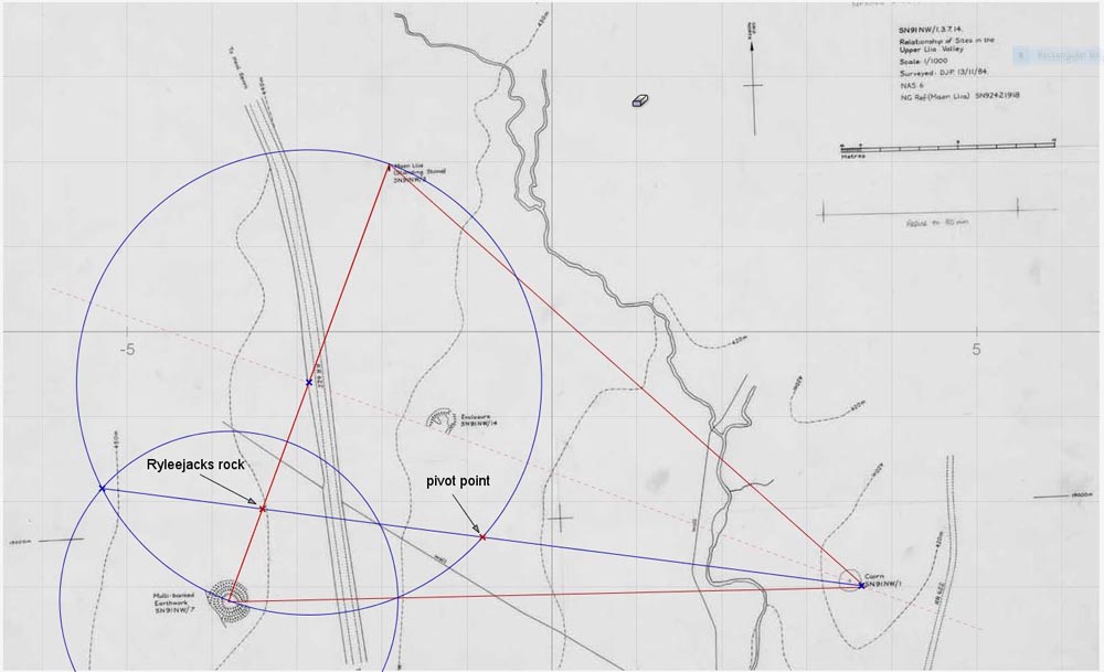
This is why the pivot point geometry is important. The position where the line drawn from the apex to the intersection of the definer with the baseline circle cuts the baseline at a point marked by RyleeJacks rock.
This rock is one of several in the valley that has a distinctive pointed shape, and this one is pointed in the direction of the cairn.
RyleeJacks rock surrounded by my minders, with Maen Llia in the background. This is looking along the triangle baseline.
RyleeJacks rock looking along its point towards Rhyd Uchaf cairn and the triangle apex's. This is NRG doing some photogrammetry.
Another way of finding the pivot point that works with all Isosceles triangles is to combine the baseline corner angle bisector and the triangle leg perpendicular bisector. Where they meet is the pivot point.
[ This message was edited by: cerrig on 2023-04-11 08:10 ]
Posted 17-06-2021 at 20:31
This is a video I made a few years ago to describe the sequence of discoveries in the Llia valley, up till about 2017 or so. There are some significant additions missing from this, but it illustrates the basic layout reasonably well, and I get to show off my advanced ceramics skills.
Another video detailing the "compass and square edge" geometry that defines the monument placings within the complex.
The basic geometry that defines the monument layout in the Llia valley
The first method I came across to construct the Garsalian triangle. There are many others.
Summer Solstice sunset shadow, not quite making it to the stream now.
The Winter solstice sunrise shadow.
Early April "false Equinox" sunset shadow, making it into the stream for the first time of the year.
Sunrise shadow, a couple of days after the "false Equinox". Note how quickly Maen Llia's full shadow is revealed from inside the shadow cast by the hill behind it.
Early April sunrise shadow. A couple of days before the perfect date.
A timelapse of the partial eclipse made on the Spring Equinox 2015.
The midday Equinox shadow, looking South.
Maen Llia in the snow.
[ This message was edited by: cerrig on 2023-04-06 17:41 ]