New Message Posted!2021-06-17 20:31
This is a video I made a few years ago to describe the sequence of discoveries in the Llia valley, up till about 2017 or so. There are some significant additions missing from this, but it illustrates the basic layout reasonably well, and I get to show off my advanced ceramics skills.
Another video detailing the "compass and square edge" geometry that defines the monument placings within the complex.
The basic geometry that defines the monument layout in the Llia valley
The first method I came across to construct the Garsalian triangle. There are many others.
Summer Solstice sunset shadow, not quite making it to the stream now.
The Winter solstice sunrise shadow.
Early April "false Equinox" sunset shadow, making it into the stream for the first time of the year.
Sunrise shadow, a couple of days after the "false Equinox". Note how quickly Maen Llia's full shadow is revealed from inside the shadow cast by the hill behind it.
Early April sunrise shadow. A couple of days before the perfect date.
A timelapse of the partial eclipse made on the Spring Equinox 2015.
The midday Equinox shadow, looking South.
Maen Llia in the snow.
[ This message was edited by: cerrig on 2023-04-06 17:41 ]
cerrig
Joined: 25-09-2009
Messages: 2912
from Brecon Beacons
OFF-Line
New Message Posted!2021-05-31 15:07
[ This message was edited by: cerrig on 2023-04-06 17:47 ]
PAB
Joined: 30-04-2006
Messages: 168
from Menevia
OFF-Line
New Message Posted!2021-03-19 23:36
"twinkling, along, flagged"
I think you must have used special influence to have your Main Llia designated thus....!
cerrig
Joined: 25-09-2009
Messages: 2912
from Brecon Beacons
OFF-Line
New Message Posted!2021-03-19 17:17
"What 3 words" co-ordinates for Maen Llia are "twinkling, along, flagged"
Seems appropriate to me.
cerrig
Runemage
Joined: 15-07-2005
Messages: 4005
from UK
OFF-Line
New Message Posted!2021-01-19 02:13
Quick Reminder
[ This message was edited by: Runemage on 2021-01-19 02:16 ]
cerrig
Joined: 25-09-2009
Messages: 2912
from Brecon Beacons
OFF-Line
New Message Posted!2020-06-04 19:33
[ This message was edited by: cerrig on 2023-03-21 11:30 ]
cerrig
Joined: 25-09-2009
Messages: 2912
from Brecon Beacons
OFF-Line
New Message Posted!2020-06-01 15:13
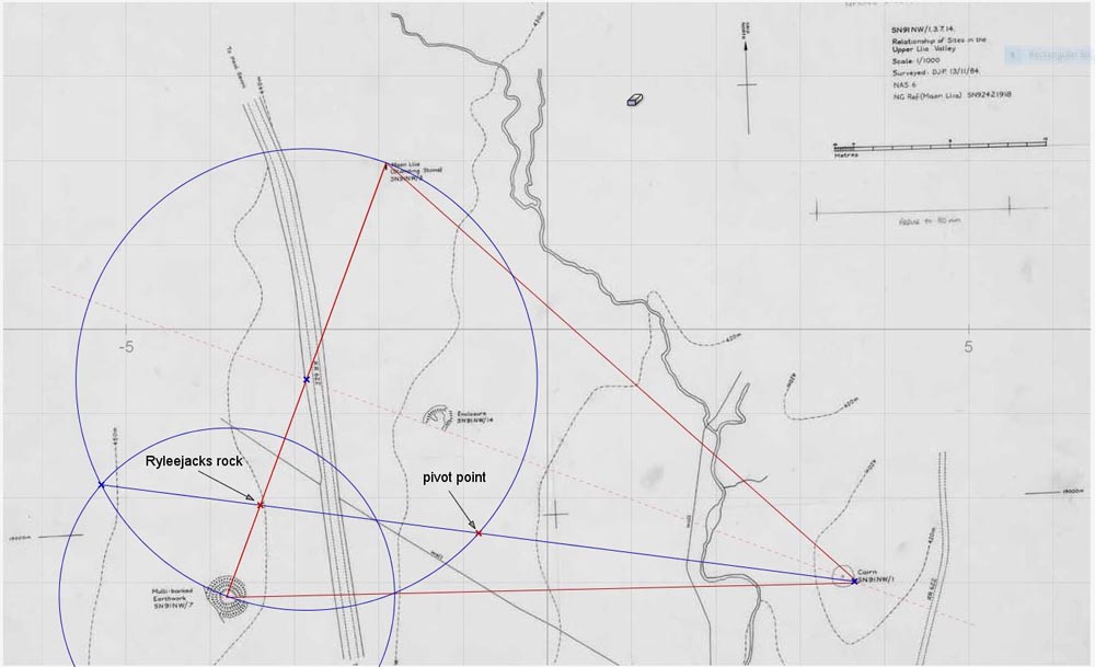
This is why the pivot point geometry is important. The position where the line drawn from the apex to the intersection of the definer with the baseline circle cuts the baseline at a point marked by RyleeJacks rock.
This rock is one of several in the valley that has a distinctive pointed shape, and this one is pointed in the direction of the cairn.
RyleeJacks rock surrounded by my minders, with Maen Llia in the background. This is looking along the triangle baseline.
RyleeJacks rock looking along its point towards Rhyd Uchaf cairn and the triangle apex's. This is NRG doing some photogrammetry.
Another way of finding the pivot point that works with all Isosceles triangles is to combine the baseline corner angle bisector and the triangle leg perpendicular bisector. Where they meet is the pivot point.
[ This message was edited by: cerrig on 2023-04-11 08:10 ]
cerrig
Joined: 25-09-2009
Messages: 2912
from Brecon Beacons
OFF-Line
New Message Posted!2020-06-01 11:55
I will try and make this as painless as I can for all for those who don't like maths but who want to learn a bit more about this. Unfortunately for those same people geometry was still geometry thousands of years ago, so it will all look depressingly similar, but while there is nothing new here in the subject what is new is the way it has been used and marked out on the ground.
Somewhere here there is a point where human endeavour and human investigation meet. A major part of my interest is finding where that point lies. I'm still looking?
The geometry that can be found in the Garsalian triangle is the main reason that I can't link the original triangular patterns to a human invention, but rather it seems to me that it can only be down to human investigation of a detectable phenomena. I don't know what this could consist of or how it was detected, but after years of trying to make the human made theory match I finally had to give up when the depth of the geometry and the way it was marked out on the ground made that theory unsustainable.
Below are examples of the Garsalian triangle geometry. This is a very small sample of it and it mainly shows some basic properties of the geometry and how it works and builds. The fractal nature of it is the killer for a human involvement from 5000 years ago.
This is the first method of drawing the triangle I ever came across. As can be seen here it is intimately tied to the Vesica Piscis.
The sequence of construction follows the letters, from drawing a circle AB on the line, then arcs BC and CB, forming the Vesica. The vertical line is drawn through A and D, and then the most important circle within the whole "style"of Garsalian geometry is drawn. This circle, which I call the "definer", opened up the whole can of worms when I moved it to the corner of the triangle, as shown, and then drew a line from the corner B through the intersection F to cut the centre line at G. This formed the first Garsalian triangle seen for thousands of years, if my research into geometry is correct that is, and the field is so vast that I can't really be certain of that, but I believe it is correct. Time will tell.
This is another way of drawing it. Using the same method but this time instead of transferring the circle a line is drawn through intersection D until it cuts the definer circle at F, the distance BF is the radius for the arc that cuts the centre line at G.
Here's another method. The same line/circle/vesica arcs construction is followed as before, this is the basis for all garsalian geometry. The centre line is extended down to F. Another vesica arc is drawn from F through E to cut the baseline at G. Another arc, centre C radius CG is drawn up to cut the centre line at H.
These are just 3 of the many ways to construct this, and the end result is exactly the same triangle.
Another feature of the geometry is its ability to grow, and the need to include all the construction lines in their entirety. For clarity I have left out the construction lines from the earlier examples overlaid onto the map because it quickly becomes a mess otherwise. When drawing otherwise I try to include all the lines as this reveals a lot that would be hidden otherwise. This is where a computer is invaluable.
Following on from the last method a bit of a tangent can be followed, because this is how I learnt by following the geometry rather than generating it myself.
If a line is drawn from A through B till it cuts the outer arc at C a new triangle exactly the same size as the original is formed, rotated through 111.4707 degrees.
Following this further, a line is drawn from A through intersection E to cut the new triangle baseline at its centre point F, and its baseline circle is drawn in. This circle cuts the original triangle leg at B and G, matching the vesica arc. This relationship shows up time and again.
This geometry is all about intersections and the way a developing construction generates new ones.
It occurred to me after this rotated triangle showed up that there would be a point inside the two triangles that served as a kind of pivot point that the rotated triangle spun around in order to reach its new position. This point lands on the baseline circle at H.
There are other Isosceles triangles with pivot points but this is the only one whose pivot point lands on the baseline like this.
This pivot point also has other properties missing from other triangles. There are several ways its position can be found by using the existing intersections.
In this one a line drawn from G to I passes through it.
When a definer circle is added this gives another method of finding the pivot point. A line drawn from the apex K down to the intersection J also goes through the pivot point, and if this is repeated for the rotated triangle to point L the same thing applies, confirming that the two triangles share the same pivot point.
cerrig
[ This message was edited by: cerrig on 2023-03-21 12:06 ]
cerrig
Joined: 25-09-2009
Messages: 2912
from Brecon Beacons
OFF-Line
New Message Posted!2020-05-14 14:26
Something that keeps on recurring in multiple ways is the concept of the first tier and its associated triangle within a triangle. The Garsalian triangle, above all others, uses this constantly. The first tier is an important element is the recumbent stone row, Rhonwens row.
This is a comparison of the first tier triangle and the triangle it came from.
I'm using my usual convention of ratio's for the lengths, with the baseline being equal to 1. As can be seen here this gives some interesting ratios, and the link between this triangle and the vesica piscis is shown in the sqrt 3( 1.73205 ) showing up all over the place. The first tier baseline length being sqrt 3 - 1 = 0.732.
When the differences in lengths between the full size and first tier triangles are compared the ratio is 1.366 : 1 . ( 1/ 0.732 )
When the areas are compared its 1.866 : 1 .( 0.6356 / 0.3406 )
Curiously, 1.866 / 1.366 = 1.366?
Another important element in Rhonwens row (extended) is the incircle. This defines the position of the "Dor stones" by it's tangent point with the leg of the greater Garsalian. This position is always precisely half the length of the baseline, (or the radius of the basline circle) so using ratios will give you the lengths of all the other components of a Garsalian triangle from knowing this one distance. The main problem is deciding which is the relevant length because of the uncertainties of the end points, a feature of investigating rough stones. I have come to the conclusion that there is a range of possibilities available, and they probably all apply. I tend to link these to known prehistoric features in order to give some context, but this is just a guide.
The image below shows various ways of finding the incentre, namely; bisecting the triangle corner angles, where they meet, on the centreline, is the incentre; drawing an arc with its centre on one of the baseline corners, equal to the baseline circle radius, that cuts the leg and then constructing a right angle from that point to cut the centre line, this is the incentre; In the case of a Garsalian, and only a Garsalian, where the first tier line cuts the centre line is the incentre, and it can also be found, only in the Garsalian, by joining the "pivot point" to one of the baseline corners. There are other ways too.
The incircle tangent point is the baseline centre of a small Garsalian when joined to the incentre, as shown here. When this centreline is extended it cuts the left hand base tier leg precisely half way between the first tier point and the corner. Again, this is only true with the Garsalian.
As can be seen, there is another correlation between lengths and areas with the incircle radius and the the first tier triangle area?
When the smaller Garsalian is replicated, as shown, it is found to be a first tier triangle of its own, defined by the full size Garsalian. Expanding and developing the geometry in this way is the essence of Garsalian geometry, and as can be seen there are numerous other Garsalian triangles evident in this diagram, just by extending existing lines. This process has no end.
The problem with this is deciding which direction to follow. This is just one of an infinite number of options that could have been taken here.
Just to show an example of an expansion, these Garsalians share the same first tier line in a way defined by the previous diagram, and the ratio between them is, again, 1.366 : 1.
[ This message was edited by: cerrig on 2023-04-10 12:46 ]
cerrig
Joined: 25-09-2009
Messages: 2912
from Brecon Beacons
OFF-Line
New Message Posted!2020-05-09 16:47 Garsalian geometry
During my investigation of the Llia valley monuments and their layout a special triangle showed up. I have called this triangle the "Garsalian" and the associated geometry that it displays I have also called "Garsalian geometry". This naming is mostly for my own benefit as a means of distinguishing it from other forms of geometry, the most relevant would probably be "Sacred geometry". There is plenty of overlap between them, and probably any form of "Euclidean" geometry too.
I am not claiming a new kind of geometry, just a different style of use. I didn't go looking for this. I was quite content to apply Sacred geometry where I could, but it didn't quite fit, and then the Garsalian triangle turned up, quite unexpectedly, completely out of the blue.
Lots of "things" have turned up "out of the blue" during my explorations in the Llia valley.
I have already shown how the Garsalian triangle first came to light. This section I am devoting to some of the properties of the triangle, just to show how special it is. A book could be written all about this triangle and its properties, which begs the questions, once again, why was it being investigated by Neolithic people, and why hasn't anyone, even those amongst the worlds great mathematicians, noticed its existence since?
Where did that knowledge go in the meantime?
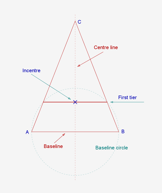
The basics of Garsalian geometry can be boiled down to just a few elements and their relationships. Centred around Isosceles triangles and their baseline circles, as shown here.
The points where the baseline circle cuts the triangle legs forms the First tier and the baseline of the new First tier triangle. This triangle comes up again and again.
This is the basic triangle.
Where the first tier line, shown here, cuts the centre line is the Incentre. This is the only triangle that has this property.
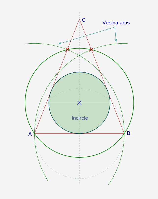
A circle drawn from the Incentre such that it passes through the baseline corners cuts through the triangle legs at the same intersections as the original Vesica Piscis. Another unique property.
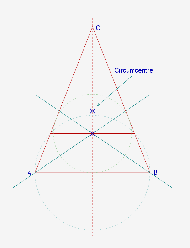
To find the Circumcentre, draw lines from both baseline corners through the Incentre and on through the triangle legs. Then join these intersections. Where this line cuts the centre line is the Circumcentre. There are other methods to find the circumcentre, but this one only works with this triangle.
The Circumcircle inner circles, shown here, have the unique property of sharing their diameter with the height to the Circumcentre from the baseline.
There are other first tier triangles formed by circles other than the baseline circles. The Garsalian triangle has some unique properties relating to these various tiered triangles that don't exist with other Isosceles triangles, which have their own relationships, but none like these.
The first tier triangle shown above is formed by the baseline circle centred on the baseline, or the definer circle centred on the triangle corner. The definer circle forms another Garsalian triangle within itself, as shown.
When the definer circle is leapfrogged up the triangle leg as shown it is found that it can be stepped off 3 times, leaving a gap at the top of the leg. This gap is exactly equal to the first tier triangle for the Garsalian formed inside the definer circle on the baseline. Only the Garsalian has this property.
Another form of tier comes from centreing the baseline circle on the corner and leapfrogging that up the leg, as shown.
This produces another gap at the top and another first tier triangle that exactly fits the baseline circle Garsalian, as per the previous definer Garsalian.
A slightly different form of tier is achieved by the Circumcircle inner circle leapfrogging up the vertical centreline and perpendiculars radiating outwards from these points to cut the legs. The resulting tiers produce the same first tier triangle relationships as the previous examples. There is much more going on here as this drawing hints at.
[ This message was edited by: cerrig on 2023-05-27 18:19 ]