

Register here - as a registered user you get more features and fewer ads.
These are worth a visit being a pair:
From stone-circles.org.uk (Chris Collyer):
The two long barrows named Deadmen's Graves I and II stand at a height of 53 metres and 51 metres above sea-level just below the southern crest of a hill rising from a steep-sided valley that runs southeast to the head of Burlands Beck which can be found in the village of Claxby St Andrew half a mile (800 metres) away.
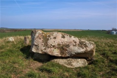
The most accessible barrow of the pair is Deadmen's Grave I at TF44427197 which is close to a farm track that leads north from the Ulceby to Claxby road and consists of a fairly well preserved trapezoid mound that still reaches a height of nearly 2 metres with a width of about 14 metres at its eastern end, but decreasing in height and width as it tails off into the trees until it reaches ground level 55 metres away to the west. It lies in an east-northeast to west-southwest orientation and like most other Lincolnshire long barrows this earth and rubble mound follows the contours of the hillside but seems to have suffered with soil alternately being built up along its northern flank while soil has spilled down the hillside along the southern flank. This movement of soil will have covered any side ditches dug to produce the material for the body of the barrow but may have helped to preserve any Neolithic remains deposited within them. Deadmen's Graves I was recorded by C.W. Phillips in 1932, who noted a pronounced 'saddle' about 20 metres from the eastern end and it could be that this saddle feature which is also seen at other Lincolnshire long barrows such as Beacon Hill and Hoe Hill is the result of the internal collapse of a wooden mortuary platform, possibly as the result of deliberate firing of the structure in a symbolic 'closing' of the barrow (see also Willerby Wold long barrow in North Yorkshire).
Also recorded by Phillips was the second barrow Deadmen's Graves II about 180 metres across the field to the southeast at TF44587189. This lies in a west-southwest by east-northeast orientation, again following the contours of the land, and measures some 53 metres in length by 18 metres at its widest eastern terminal. However this barrow has been badly damaged in places and is overgrown with trees with a now abandoned chalk pit quarried into its centre which almost cuts the mound in two. Despite this it survives to a height of about half a metre for most of its length, rising to abound 2 metres at its eastern end. Again, soil has slipped down the hillside from the mound over the years which along with the quarrying has distorted its original form and buried the flanking ditches..
Something is not right. This message is just to keep things from messing up down the road