

Register here - as a registered user you get more features and fewer ads.
Hi, I thought I had posted this a few years ago but it seems maybe not, or I just can't find it!
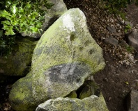
I know of a possible 'puddingstone' in the village of Denston in Suffolk. Until moved recently by philistine property developers, it sat on a crossroads, at a river crossing, and where the boundaries of two different villages meet. It has always been considered by historians to be the original 'settlement' stone of the village, and is shown as a boundary marker on maps of the 1800s.
I grew up in the pub which the stone sat in front of, and so when the building were unsympathetically part demolished and redeveloped a few years ago, with the stone being pointlessly removed from its longstanding and historically significant position, I put together research to ensure that the local archaeological service would ensure that it was protected.
The stone was recognised as being historically important, and I was told by St Edmundsbury Archaeology dept that it would be added to the HER, but it hasn't been so far.
The stone can now be seen just to the side of the main frontage of the building. The pub was previously known as 'The Plumbers Arms' but the redevelopment is now called Plumbers Mews, and is on the A143 halfway between Bury St Edmunds and Haverhill. I'd be really interested to hear peoples thoughts on this location and route.
Site of the stone while I lived there: https://www.google.co.uk/maps/@52.1575294,0.5687984,3a,37.5y,264.25h,61.9t/data=!3m6!1e1!3m4!1sCxNzNLSuswbeaPKFiErjtQ!2e0!7i13312!8i6656
It was originally right on the corner of the building (high left of the image) but is now tucked around the other side, behind this image.
Something is not right. This message is just to keep things from messing up down the road