

Register here - as a registered user you get more features and fewer ads.
RCHMS report of field visit 22nd June 2005:
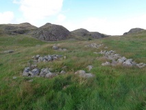
"This grass-grown ring-cairn stands on a broad natural terrace in improved pasture 175m W of the road leading from Dinnet to Milton of Logie (B9119). Polygonal on plan, it measures 15m from E to W by 14.5m transversely over a discontinuous kerb of water-worn boulders and edge-set slabs rising up to 0.5m in height. This kerb is best preserved on the NW and SE, and, although it is not graded in height, the smaller boulders and slabs tend to be situated on the N, while the larger are on the S. A shallow oval hollow, which measures 9m from WNW to ESE by 7.3m transversely and up to 0.4m in depth, may be a central court although no evidence of an inner kerb is visible. A heap of field cleared stones overlies the NE side of this hollow."
Something is not right. This message is just to keep things from messing up down the road