

Register here - as a registered user you get more features and fewer ads.
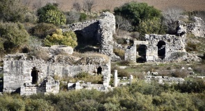
The main western rampart, cut into the crest of the valley facing the river is probably more like 20 ft or more from ditch to top. The depth of ditch/rampart height recedes as it circles round to the plateau at the eastern edge of the earthworks to approx 8ft minimum at the extreme NE & SE points of the earthwork. Indeed the rampart and ditch almost disappear completely at the most easterly point for,some 15 yards or so where the forestry track running due south from pipers lane cuts across it. The site may be entered from here by those less physically able or who prefer to keep dry shoes (The ditch retains a substantial amount of water on the North, West and South sides, where the slope westwards is steeper and more deeply cut.) The ditch seems to be so well preserved because this is in a heavily wooded hanger or valley and has not been ploughed out. Mature trees bound the perimeter and have helped to hold the soil and shape of the fort.
The whole orientation and emphasis of defence is to the due West, facing across the River Kird and toward the Rother Valley. Indeed the site would look to be fairly vulnerable if it were approached from any other direction, North, South or especially the East, where the land plateaus immediately to the East of the works.
Why would someone place a fort here? There are no immediately large historic settlements locally and pipers lane is not a Roman road or ancient trackway. Yet the orientation of the site is overwhelmingly pointing to a defence of the East bank of the Kird from attack in the direction of the West. The Western rampart must be no more than 160 metres from the east bank (within easy bow shot, especially from such a high trajectory) but is made especially difficult to approach by (I) The River; which even in living memory took tup to three times the flow it does today. As you cross the river just south of the modern day bridge, three further river channels are evident. This would have made the Kird at least a twenty yard obstacle instead of the twenty feet it is now. The formation of hammer ponds to the North side of the bridge has also lessened its volume and channelled it more narrowly and deeper.
(ii) The steep slope rising from the crossing toward the fort is indeed formidable, rising almost sheer in front of the main Western rampart but less so toward the approaches to the North and South sides which plateau almost halfway along their length as they curve back on themselves to encircle the crest of the hill.
The positioning of such a minor fortification is strange. Was it built in the shifting borderlands between Wessex and Sussex to discourage attacks from the West primarily, or is there another reason?
The whole of the river bed is festooned with iron slag, ancient and modern. I have read previously that iron workings were releatively rare in the South outside of the Weald. Was a fort built to protect those interests? The area was extensively worked up until the mid 19th century, when the reserves to effort ratio obviously ran low (the area between here and Midhurst famously provided iron for the Royal Armouries for a protracted number of years) Was this site rich enough that the Romans protected it with a fort? Back then, more than likely.
a The occupation record for the site is supposedly runs from Bronze Age through to medieval, which would ask the question as to what was it of value here that ensured a continuous occupation of the site. There is much evidence of settlement to the North of the current bridge, running along the East bank of the river heading North and West toward Dares Farm, with terracing and surface mining still obvious to the eye. The size and shape of the site should suggest that this is no Finlandia. The origin of the fort must be pre-Roman as its shape and construction would not lend it to any Roman engineer. At probably most only one acre in area, it would have held no more than 500 defenders at most-too small for a Roman effort? The shape is not circular but not square either- this may point to changes over time.
Best time to visit this place is early spring, before the leaves are in full spate. iT is then much easier to see right across the works and to appreciate the drop off down to the river. Anybody with any more thoughts on why this is sited here?? ANY OTHER IDEAS AT ALL?
Roger Jeffery 18/09/16
Something is not right. This message is just to keep things from messing up down the road