

Register here - as a registered user you get more features and fewer ads.
July 2013
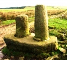
I visited Ewden Beck stone circle yesterday purely through facination. Ignorantly and having no qualifications in the subject I tried to understand it's context within the landscape through interest and curiosity. I was expecting a smaller version of Castle Rigg....very dissapointed. However, I did use my transferable skills by plotting summer/winter astronomical lines aswell as it's position in the landscape. Here are my results (opinions and constructive comments most welcome):
Regardless of where the centre of the circle is (I was stood inside the circle area at all approximate stone positions), I took bearings and discovered that at the summer solstice, the sun rose above and from the v shaped piece of land on a compass bearing of roughly 60 degrees which is north east. It set again in the v shaped piece of land to the north west at roughly 130 degrees.
Winter solstice suggested the sun rising directly above Wigtwizzle with no discernable feature and setting in a similar direction to the near parallel earthwork ditch a few hundred metres to the south. I'm not suggesting that these are related.
Interestingly, noon on both mid summer and mid winter suggested a bearing south, of 185 degrees which coincidence or not, aligns with a v shaped peice of land on the horizon from which a stream seems to start.
With regards to the large 'entrance' stones, they DO NOT appear to align to anything. However, a discernable line of stones run from the 12 position to the 7 oclock position which DOES align to the noon day positions of summer and winter.
My thoughts are that it was assembled (stone circle or barrow or cairn), during the darker months when the sun's position wasn't obvious such as late autumn/winter and corrected when the sun was more obvious like late spring/early summer? Perhaps an adjustment through time. Either way, if your going to move large rocks around you'll need to drink alot of water which could be why it was sited near the stream and at the head of a confluence?
On a broader note, the earthworks just south of the site seem to be a defensive gesture from a percieved threat from further south and protecting the suggested barrows/burials (unconfirmed) to the north of the earthwork some 1.75 mile long that runs in an east/west direction. There are many examples of this. The Cleave Dyke system being one of them which appears to be protecting burials/barrows from a percieved threat mainly from the east.
Could the earthworks at Ewden Beck be a continuance of the Roman Ridge system at Wincobank?
If I were a betting man, I would suggest that if a line was drawn from the centre of the site along the bearings that I suggested this would inevitably cross another important feature just like other sites around the country...Stonehenge burials on the 'noon' line or entrance to the henge on the summer solstice line.....Arbor Low burials on the 'noon' line or entrance to the henge on the solstice line....etc etc...
All contructive feedback and thoughts very, very welcome!
[email protected]
Something is not right. This message is just to keep things from messing up down the road