

Register here - as a registered user you get more features and fewer ads.
Craig Dunain
West of Iverness separating the Beauly Firth and the Loch Ness Road 1.5 miles out of Inverness is an esker ridge left by glaciation. Its the highest spot in the area and a logical place for any prehistoric fortifications. Named Craig Dunain the area is heavily wooded and called Dunain woods on the northern side of the ridge is Craig phadraig a strange flat topped hill the summit contains a Pictish Fort built in 5th or 4th century BC http://dunainwoods.co.uk/past.htm
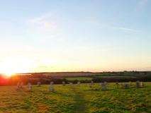
A ruined 'passage grave' dating from around 3000 BC is situated on the highest ground of the Leachkin ridge . The polygonal burial chamber was originally contained within a 70ft cairn, none of which remains. The entrance passage would have been from the NE leading to a bigger second passage and a much higher inner chamber. One large standing stone remains erect. We can only speculate as to the rituals that may have been enacted at this spot. The chambered cairn is of the Orkney/Cromarty type which is found on high ground only from west of Inverness to the far north. It is unlike the Clava cairn types which are found on low lying land to the east and south.
Whilst there is no stone circle, there is enough archeological remains including one standing stone to speculate that this was the area used as a basis for the book. It is also geographically within walking distance of Inverness town.
PA - Inverness
Something is not right. This message is just to keep things from messing up down the road