<< Our Photo Pages >> Devil's Stone (Dorset) - Standing Stone (Menhir) in England in Dorset
Submitted by traveller on Sunday, 07 March 2004 Page Views: 13355
Neolithic and Bronze AgeSite Name: Devil's Stone (Dorset)Country: England County: Dorset Type: Standing Stone (Menhir)
Nearest Town: Blandford Forum Nearest Village: Bere Regis
Map Ref: SY837941 Landranger Map Number: 194
Latitude: 50.746272N Longitude: 2.232395W
Condition:
| 5 | Perfect |
| 4 | Almost Perfect |
| 3 | Reasonable but with some damage |
| 2 | Ruined but still recognisable as an ancient site |
| 1 | Pretty much destroyed, possibly visible as crop marks |
| 0 | No data. |
| -1 | Completely destroyed |
| 5 | Superb |
| 4 | Good |
| 3 | Ordinary |
| 2 | Not Good |
| 1 | Awful |
| 0 | No data. |
| 5 | Can be driven to, probably with disabled access |
| 4 | Short walk on a footpath |
| 3 | Requiring a bit more of a walk |
| 2 | A long walk |
| 1 | In the middle of nowhere, a nightmare to find |
| 0 | No data. |
| 5 | co-ordinates taken by GPS or official recorded co-ordinates |
| 4 | co-ordinates scaled from a detailed map |
| 3 | co-ordinates scaled from a bad map |
| 2 | co-ordinates of the nearest village |
| 1 | co-ordinates of the nearest town |
| 0 | no data |
Internal Links:
External Links:
")
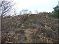
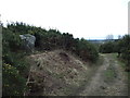
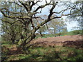
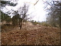
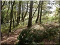
It took some time to find this one, as you can see the hedge has grown rather a lot since Peter Knight reported it in “Ancient Stones of Dorset”. He describes it as a Heathstone Monolith, utilised by the Romans as a marker, lying close to a Roman Rd on the summit of Black Hill.
You may be viewing yesterday's version of this page. To see the most up to date information please register for a free account.
Do not use the above information on other web sites or publications without permission of the contributor.
Nearby Images from Geograph Britain and Ireland:
©2012(licence)
©2012(licence)
©2006(licence)
©2013(licence)
©2009(licence)
The above images may not be of the site on this page, they are loaded from Geograph.
Please Submit an Image of this site or go out and take one for us!
Click here to see more info for this site
Nearby sites
Key: Red: member's photo, Blue: 3rd party photo, Yellow: other image, Green: no photo - please go there and take one, Grey: site destroyed
Download sites to:
KML (Google Earth)
GPX (GPS waypoints)
CSV (Garmin/Navman)
CSV (Excel)
To unlock full downloads you need to sign up as a Contributory Member. Otherwise downloads are limited to 50 sites.
Turn off the page maps and other distractions
Nearby sites listing. In the following links * = Image available
981m E 81° Wool Road Sarsen Stone* Standing Stone (Menhir) (SY8467394244)
2.0km ENE 70° Woodbury Hill (Dorset)* Hillfort (SY856948)
2.9km NNW 340° Milborne St Andrew 1 Round Barrow(s) (SY827968)
3.3km NNW 348° Milborne St Andrew 2 Round Barrow(s) (SY830973)
3.7km NW 305° Weatherby Castle* Hillfort (SY807962)
4.4km NE 36° Winterborne Kingston Standing Stone (Menhir) (SY863977)
5.2km NNW 341° Deverel Barrow* Round Barrow(s) (SY820990)
5.8km ESE 106° Woolsbarrow* Hillfort (SY893925)
8.1km N 10° Combs Ditch Ancient Village or Settlement (ST851021)
8.4km SSW 201° Blacknoll Hill* Barrow Cemetery (SY80638630)
8.4km S 172° Woodman's Cross* Barrow Cemetery (SY84838573)
9.3km SE 136° Wareham Barrows Barrow Cemetery (SY90128737)
10.0km SSE 167° Coombe Beacon Barrow Cemetery (SY860844)
10.4km WSW 258° Rainbarrows* Round Barrow(s) (SY735920)
10.6km SE 127° Wareham Walls* Misc. Earthwork (SY92218771)
10.8km WSW 255° Heedless William's Stone* Standing Stone (Menhir) (SY732913)
10.9km SSE 157° Povington Heath Barrows Barrow Cemetery (SY880841)
11.0km SSW 205° Five Marys* Barrow Cemetery (SY790842)
11.0km NE 44° Spettisbury Rings* Hillfort (ST914020)
11.0km NW 313° Giant's Grave Sarsen Stone* Standing Stone (Menhir) (ST757017)
11.2km SE 128° Lady St Mary (Wareham)* Ancient Cross (SY92498719)
11.2km WNW 299° Cheselbourne Round Barrow(s) (SY739995)
11.5km SSW 211° Lord's Barrow* Round Barrow(s) (SY778842)
12.1km SE 141° Three Lord's Round Barrow(s) (SY914847)
12.2km NE 52° Shapwick Round Barrow(s) (ST9336301635)
View more nearby sites and additional images


 We would like to know more about this location. Please feel free to add a brief description and any relevant information in your own language.
 Wir möchten mehr über diese Stätte erfahren. Bitte zögern Sie nicht, eine kurze Beschreibung und relevante Informationen in Deutsch hinzuzufügen.
 Nous aimerions en savoir encore un peu sur les lieux. S'il vous plaît n'hesitez pas à ajouter une courte description et tous les renseignements pertinents dans votre propre langue.
 Quisieramos informarnos un poco más de las lugares. No dude en añadir una breve descripción y otros datos relevantes en su propio idioma.