

<< Text Pages >> Kenwalch's Castle Fort - Hillfort in England in Wiltshire
Submitted by Bladup on Friday, 14 November 2025 Page Views: 551
Iron Age and Later PrehistorySite Name: Kenwalch's Castle FortCountry: England County: Wiltshire Type: Hillfort
Map Ref: ST74753352
Latitude: 51.100422N Longitude: 2.361989W
Condition:
| 5 | Perfect |
| 4 | Almost Perfect |
| 3 | Reasonable but with some damage |
| 2 | Ruined but still recognisable as an ancient site |
| 1 | Pretty much destroyed, possibly visible as crop marks |
| 0 | No data. |
| -1 | Completely destroyed |
| 5 | Superb |
| 4 | Good |
| 3 | Ordinary |
| 2 | Not Good |
| 1 | Awful |
| 0 | No data. |
| 5 | Can be driven to, probably with disabled access |
| 4 | Short walk on a footpath |
| 3 | Requiring a bit more of a walk |
| 2 | A long walk |
| 1 | In the middle of nowhere, a nightmare to find |
| 0 | No data. |
| 5 | co-ordinates taken by GPS or official recorded co-ordinates |
| 4 | co-ordinates scaled from a detailed map |
| 3 | co-ordinates scaled from a bad map |
| 2 | co-ordinates of the nearest village |
| 1 | co-ordinates of the nearest town |
| 0 | no data |
Internal Links:
External Links:
Hillfort in Wiltshire
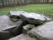
Kenwalch's Castle Fort is a large univallate hillfort situated on the north end of a ridge in the hills of the Somerset/Wiltshire border. The fort has an internal area of 1.6ha and is sub-rectangular in shape, drawing to a point on the north - a plan determined by the natural contours of the hill. The earthworks consist of a bank and external ditch or terrace. They are most massive on the south against the rising ground, with the bank up to 2m high and the ditch 2m deep outside it. On the north tip the bank is 0.5m high within a ditch 2m deep. The west and east sides make use of the natural slope to form a drop of 2m-3m from a bank 0.5m high to a ditch 0.5m deep. Along much of the steep west side the ditch becomes a broad terrace 3m-4m wide. The original entrances to the fort are likely to have been in the centre of the north and south sides, at which points today a minor road enclosed by banks now runs through. The present gaps are wider than the road, suggesting a former trackway along the ridge with a broader course. There is a second gap on the NNW adjacent to that through which the road runs, and this may be the original entrance gap. An entrance in the south-west corner of the fort is unlikely to be original and probably relates to the creation of a track running through it, around the inside of the rampart, and through the NNW gap parallel to the road. This track at some points runs along a slight terrace inside the ramparts. There is also a small gap in the bank on the south-east.
You may be viewing yesterday's version of this page. To see the most up to date information please register for a free account.
")
Do not use the above information on other web sites or publications without permission of the contributor.
Nearby Images from Geograph Britain and Ireland:

©2025(licence)

©2025(licence)

©2025(licence)

©2025(licence)

©2025(licence)
The above images may not be of the site on this page, they are loaded from Geograph.
Please Submit an Image of this site or go out and take one for us!
Click here to see more info for this site
Nearby sites
Key: Red: member's photo, Blue: 3rd party photo, Yellow: other image, Green: no photo - please go there and take one, Grey: site destroyed
Download sites to:
KML (Google Earth)
GPX (GPS waypoints)
CSV (Garmin/Navman)
CSV (Excel)
To unlock full downloads you need to sign up as a Contributory Member. Otherwise downloads are limited to 50 sites.
Turn off the page maps and other distractions
Nearby sites listing. In the following links * = Image available
2.0km NE 54° Park Hill Camp (Stourhead)* Hillfort (ST76383471)
2.3km NE 35° St. Peter's Pump* Holy Well or Sacred Spring (ST761354)
3.5km SE 131° Egbert's Stone Marker Stone (ST774312)
3.6km SE 129° Bourton Monolith* Standing Stone (Menhir) (ST7757731221)
5.6km ENE 73° Whitesheet Hill* Ancient Village or Settlement (ST80163518)
5.7km E 79° Whitesheet Castle* Hillfort (ST804346)
5.8km SSW 214° Wincanton and District Museum* Museum (ST7149528680)
5.9km SW 218° Shad Well* Holy Well or Sacred Spring (ST711289)
5.9km SSW 199° Physic Well (Wincanton) Holy Well or Sacred Spring (ST728279)
6.1km ENE 70° Whitesheet Downs Earthwork Misc. Earthwork (ST80503555)
6.1km S 172° St Barbara's Well* Holy Well or Sacred Spring
6.4km WNW 282° Patwell* Holy Well or Sacred Spring (ST6843434863)
7.7km NE 44° Town Well (Maiden Bradley) Holy Well or Sacred Spring (ST8010039028)
7.7km ENE 72° Rodmead Hill Enclosure Ancient Village or Settlement (ST82123593)
7.8km ENE 74° Rodmead Barrow Cemetery Barrow Cemetery (ST823356)
8.1km N 354° Witham Friary I Round Barrow(s) (ST74014156)
8.4km N 3° Witham Friary 2 Round Barrow(s) (ST75264194)
9.1km SE 139° Gillingham Vicarage (Dorset) Ancient Cross (ST80682656)
10.2km NNE 12° Conquest Field Round Barrow(s) (ST77004347)
10.4km NW 313° Evercreech 14-15 Bowl Barrows* Round Barrow(s) (ST67094063)
10.8km NW 311° Small Down Barrows* Barrow Cemetery (ST666406)
10.8km NW 311° Small Down Camp* Hillfort (ST666407)
10.9km E 98° Puckwell* Holy Well or Sacred Spring (ST856319)
12.3km N 350° Nunney Artificial Mound (ST72734564)
12.8km NW 316° West Cranmore Round Barrows* Barrow Cemetery (ST65844274)
View more nearby sites and additional images


 We would like to know more about this location. Please feel free to add a brief description and any relevant information in your own language.
 Wir möchten mehr über diese Stätte erfahren. Bitte zögern Sie nicht, eine kurze Beschreibung und relevante Informationen in Deutsch hinzuzufügen.
 Nous aimerions en savoir encore un peu sur les lieux. S'il vous plaît n'hesitez pas à ajouter une courte description et tous les renseignements pertinents dans votre propre langue.
 Quisieramos informarnos un poco más de las lugares. No dude en añadir una breve descripción y otros datos relevantes en su propio idioma.