 with our Megalithic Portal iPhone app")

<< Our Photo Pages >> Priddy long barrow - Long Barrow in England in Somerset
Submitted by caradoc68 on Sunday, 29 December 2013 Page Views: 4855
Neolithic and Bronze AgeSite Name: Priddy long barrowCountry: England County: Somerset Type: Long Barrow
Nearest Town: Wells Nearest Village: Priddy
Map Ref: ST5141550915
Latitude: 51.255318N Longitude: 2.697588W
Condition:
| 5 | Perfect |
| 4 | Almost Perfect |
| 3 | Reasonable but with some damage |
| 2 | Ruined but still recognisable as an ancient site |
| 1 | Pretty much destroyed, possibly visible as crop marks |
| 0 | No data. |
| -1 | Completely destroyed |
| 5 | Superb |
| 4 | Good |
| 3 | Ordinary |
| 2 | Not Good |
| 1 | Awful |
| 0 | No data. |
| 5 | Can be driven to, probably with disabled access |
| 4 | Short walk on a footpath |
| 3 | Requiring a bit more of a walk |
| 2 | A long walk |
| 1 | In the middle of nowhere, a nightmare to find |
| 0 | No data. |
| 5 | co-ordinates taken by GPS or official recorded co-ordinates |
| 4 | co-ordinates scaled from a detailed map |
| 3 | co-ordinates scaled from a bad map |
| 2 | co-ordinates of the nearest village |
| 1 | co-ordinates of the nearest town |
| 0 | no data |
Internal Links:
External Links:
")
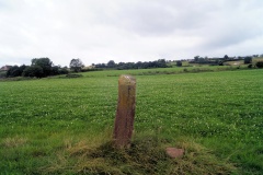
The southern end had been disturbed by an earlier excavation during the early 19th century. The barrow is still extant as an earthwork mound.
You may be viewing yesterday's version of this page. To see the most up to date information please register for a free account.
")
Do not use the above information on other web sites or publications without permission of the contributor.
Nearby Images from Geograph Britain and Ireland:

©2010(licence)

©2018(licence)
©2013(licence)

©2013(licence)

©2018(licence)
The above images may not be of the site on this page, they are loaded from Geograph.
Please Submit an Image of this site or go out and take one for us!
Click here to see more info for this site
Nearby sites
Key: Red: member's photo, Blue: 3rd party photo, Yellow: other image, Green: no photo - please go there and take one, Grey: site destroyed
Download sites to:
KML (Google Earth)
GPX (GPS waypoints)
CSV (Garmin/Navman)
CSV (Excel)
To unlock full downloads you need to sign up as a Contributory Member. Otherwise downloads are limited to 50 sites.
Turn off the page maps and other distractions
Nearby sites listing. In the following links * = Image available
751m N 8° Townsend Farm Barrow Cemetery* Barrow Cemetery (ST5152851658)
791m SW 225° Westbury-Sub-Mendip Cave or Rock Shelter (ST50855036)
867m NNW 329° Bristol Plain Farm Barrow Cemetery* Barrow Cemetery (ST5097951665)
1.3km ENE 67° Priddy Church Barrows* Barrow Cemetery (ST526514)
1.7km NNW 342° Cheddar Head Stone Circle (ST509525)
2.2km S 169° Deerleap Stones* Standing Stones (ST51804876)
2.2km W 275° Westbury Camp* Hillfort (ST49205112)
2.4km E 99° Eastwater Tumuli Round Barrow(s) (ST5377250539)
2.6km ENE 76° Priddy Nine Barrows* Barrow Cemetery (ST53925149)
2.7km ENE 65° Ashen Hill Barrows* Barrow Cemetery (ST53905205)
3.0km ENE 56° Priddy Circles S* Henge (ST53945255)
3.1km E 92° Fair Lady Well* Holy Well or Sacred Spring (ST54515079)
3.2km NE 53° Priddy Circles* Henge (ST54005280)
3.2km NE 54° Priddy Circles C* Henge (ST54015279)
3.4km NE 51° Priddy Circles N* Henge (ST54095302)
3.4km SSE 148° Wookey Hole Caves* Cave or Rock Shelter (ST53194801)
3.5km SSE 148° Badger Hole (Somerset) Cave or Rock Shelter (ST53244795)
3.5km ENE 62° Castle Farm Long Barrow* Long Barrow (ST54525255)
3.5km WNW 289° Batcombe Hollow north stone* Standing Stone (Menhir) (ST4810452088)
3.6km SSE 152° Wookey Hole Caves Museum* Museum (ST531477)
3.7km WNW 284° Batcombe Hollow south standing stone* Standing Stone (Menhir) (ST4782451823)
3.8km NNE 19° Wright's Piece barrows (S)* Barrow Cemetery (ST527545)
3.8km NE 46° Priddy Circles Unfinished N* Henge (ST54215355)
4.0km NE 35° Pool Farm Cist* Rock Art (ST53745415)
4.1km NW 310° Totty Pot Cave or Rock Shelter (ST48255358)
View more nearby sites and additional images


 We would like to know more about this location. Please feel free to add a brief description and any relevant information in your own language.
 Wir möchten mehr über diese Stätte erfahren. Bitte zögern Sie nicht, eine kurze Beschreibung und relevante Informationen in Deutsch hinzuzufügen.
 Nous aimerions en savoir encore un peu sur les lieux. S'il vous plaît n'hesitez pas à ajouter une courte description et tous les renseignements pertinents dans votre propre langue.
 Quisieramos informarnos un poco más de las lugares. No dude en añadir una breve descripción y otros datos relevantes en su propio idioma.