

<< Our Photo Pages >> The Wimblestone - Standing Stone (Menhir) in England in Somerset
Submitted by PhilW on Saturday, 11 May 2024 Page Views: 21340
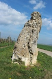
Neolithic and Bronze AgeSite Name: The Wimblestone Alternative Name: Old WimbleCountry: England County: Somerset Type: Standing Stone (Menhir)
Nearest Town: Weston-super-Mare Nearest Village: Star
Map Ref: ST43355848 Landranger Map Number: 172
Latitude: 51.322588N Longitude: 2.814348W
Condition:
| 5 | Perfect |
| 4 | Almost Perfect |
| 3 | Reasonable but with some damage |
| 2 | Ruined but still recognisable as an ancient site |
| 1 | Pretty much destroyed, possibly visible as crop marks |
| 0 | No data. |
| -1 | Completely destroyed |
| 5 | Superb |
| 4 | Good |
| 3 | Ordinary |
| 2 | Not Good |
| 1 | Awful |
| 0 | No data. |
| 5 | Can be driven to, probably with disabled access |
| 4 | Short walk on a footpath |
| 3 | Requiring a bit more of a walk |
| 2 | A long walk |
| 1 | In the middle of nowhere, a nightmare to find |
| 0 | No data. |
| 5 | co-ordinates taken by GPS or official recorded co-ordinates |
| 4 | co-ordinates scaled from a detailed map |
| 3 | co-ordinates scaled from a bad map |
| 2 | co-ordinates of the nearest village |
| 1 | co-ordinates of the nearest town |
| 0 | no data |
Internal Links:
External Links:
I have visited· I would like to visit
Spud_303 visited on 1st Mar 2026 - their rating: Cond: 3 Amb: 3 Access: 1 Have visited here before as a young lad but had approached it from a different direction.
The site is a little difficult to reach, but a tenacious walker will find a way into the field where it hides.
There were two sheep skulls placed at the base. Symbolic to someone, I’m sure.
philw visited on 22nd Aug 2020 - their rating: Cond: 4 Amb: 4 Access: 3 easy access through a field
hamish have visited here
Average ratings for this site from all visit loggers: Condition: 3.5 Ambience: 3.5 Access: 2
")
The Wimblestone is described by D.P.Dobson in his book The Archaeology of the County of Somerset published in 1931. Located near the Ship Inn, Dobson describes it as being ‘5 feet high, by 5 feet 5 inches wide at the base, where it is 1 foot 5 inches thick’, but interestingly he makes no reference to the hole. He also refers to five large pieces of conglomerate close by and in the same field three other fairly large stones with a stony ridge leading up to them.
Page originally by Vicky
Note: There is no other megalith in Somerset or the Bristol region which has such a wealth of folklore surrounding it than "Old Wimble" - details in the comment on our page
You may be viewing yesterday's version of this page. To see the most up to date information please register for a free account.
")
")
")
")
")
")
")
")
")
")
Do not use the above information on other web sites or publications without permission of the contributor.
Click here to see more info for this site
Nearby sites
Key: Red: member's photo, Blue: 3rd party photo, Yellow: other image, Green: no photo - please go there and take one, Grey: site destroyed
Download sites to:
KML (Google Earth)
GPX (GPS waypoints)
CSV (Garmin/Navman)
CSV (Excel)
To unlock full downloads you need to sign up as a Contributory Member. Otherwise downloads are limited to 50 sites.
Turn off the page maps and other distractions
Nearby sites listing. In the following links * = Image available
1.6km E 94° Barrow at Rowberrow* Round Barrow(s) (ST44925834)
1.7km ENE 75° Dolebury Camp* Hillfort (ST450589)
2.5km WNW 281° Banwell Camp* Hillfort (ST4090059000)
2.7km ESE 121° Cuck Hill Barrow Round Barrow(s) (ST4567057030)
3.6km W 278° Butstone (Banwell) Marker Stone (ST398590)
3.7km SW 225° Wavering Down cairn* Round Cairn (ST40705590)
3.8km NW 308° Banwell Moor Stone 2 Marker Stone (ST40406086)
3.9km S 182° Axbridge Church Wells* Holy Well or Sacred Spring (ST432546)
4.2km ESE 109° Black Down barrows (Mendip)* Barrow Cemetery (ST473571)
4.2km ESE 120° Tynings Farm Barrow Group* Barrow Cemetery (ST47005635)
4.3km E 87° Aveline's Hole* Cave or Rock Shelter (ST47615867)
4.3km W 261° Wook's Quoit* Standing Stone (Menhir) (ST39045783)
4.4km SSW 213° Compton Bishop* Standing Stones (ST409548)
4.5km E 86° Burrington Camp* Hillfort (ST47825878)
4.9km SW 230° Compton Bishop Church Cross* Ancient Cross (ST3959955378)
5.1km WNW 301° Banwell Moor Stone 1 Marker Stone (ST39036113)
5.1km NW 311° Banwell Moor Stone 4 Marker Stone (ST39576188)
5.2km ESE 103° Beacon Batch* Barrow Cemetery (ST48465726)
5.3km N 2° Congresbury Church Cross* Ancient Cross (ST4359863744)
5.3km WNW 300° Rolstone* Standing Stone (Menhir) (ST38736120)
5.4km N 3° Congresbury Village Cross* Ancient Cross (ST4373263818)
5.5km SE 142° Sun Hole* Cave or Rock Shelter (ST467541)
5.5km SSE 147° Flint Jack's Cave Cave or Rock Shelter (ST463538)
5.5km W 261° Flagstaff Hill* Stone Circle (ST3785257630)
5.6km SE 143° Cheddar Museum of Prehistory* Museum (ST46655393)
View more nearby sites and additional images


 We would like to know more about this location. Please feel free to add a brief description and any relevant information in your own language.
 Wir möchten mehr über diese Stätte erfahren. Bitte zögern Sie nicht, eine kurze Beschreibung und relevante Informationen in Deutsch hinzuzufügen.
 Nous aimerions en savoir encore un peu sur les lieux. S'il vous plaît n'hesitez pas à ajouter une courte description et tous les renseignements pertinents dans votre propre langue.
 Quisieramos informarnos un poco más de las lugares. No dude en añadir una breve descripción y otros datos relevantes en su propio idioma.