<< Text Pages >> Pwll Byfre Hut Circle 1 - Ancient Village or Settlement in Wales in Powys
Submitted by coldrum on Thursday, 07 January 2010 Page Views: 3505
Multi-periodSite Name: Pwll Byfre Hut Circle 1Country: Wales County: Powys Type: Ancient Village or Settlement
Map Ref: SN87501711
Latitude: 51.841224N Longitude: 3.634372W
Condition:
| 5 | Perfect |
| 4 | Almost Perfect |
| 3 | Reasonable but with some damage |
| 2 | Ruined but still recognisable as an ancient site |
| 1 | Pretty much destroyed, possibly visible as crop marks |
| 0 | No data. |
| -1 | Completely destroyed |
| 5 | Superb |
| 4 | Good |
| 3 | Ordinary |
| 2 | Not Good |
| 1 | Awful |
| 0 | No data. |
| 5 | Can be driven to, probably with disabled access |
| 4 | Short walk on a footpath |
| 3 | Requiring a bit more of a walk |
| 2 | A long walk |
| 1 | In the middle of nowhere, a nightmare to find |
| 0 | No data. |
| 5 | co-ordinates taken by GPS or official recorded co-ordinates |
| 4 | co-ordinates scaled from a detailed map |
| 3 | co-ordinates scaled from a bad map |
| 2 | co-ordinates of the nearest village |
| 1 | co-ordinates of the nearest town |
| 0 | no data |
Be the first person to rate this site - see the 'Contribute!' box in the right hand menu.
Internal Links:
External Links:
Ancient Village or Settlement in Powys
From Coflein:
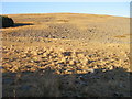
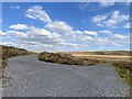
"On a S-facing slope overlooking Pwll Byfre at 500m above O.D. on open moorland, two possible hut circles lie on the N edge of a modern track. The better-preserved of the two measures approximately 7m in overall diameter and 2.5m across internally and consists of a stony bank up to 0.3m high. No entrance is visible, although the bank is lowest on the SW."
https://www.coflein.gov.uk/en/site/84390
You may be viewing yesterday's version of this page. To see the most up to date information please register for a free account.
Do not use the above information on other web sites or publications without permission of the contributor.
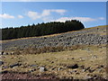
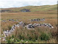
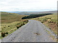
Nearby Images from Geograph Britain and Ireland:
©2008(licence)
©2015(licence)
©2022(licence)
©2022(licence)
©2020(licence)
The above images may not be of the site on this page, they are loaded from Geograph.
Please Submit an Image of this site or go out and take one for us!
Click here to see more info for this site
Nearby sites
Key: Red: member's photo, Blue: 3rd party photo, Yellow: other image, Green: no photo - please go there and take one, Grey: site destroyed
Download sites to:
KML (Google Earth)
GPX (GPS waypoints)
CSV (Garmin/Navman)
CSV (Excel)
To unlock full downloads you need to sign up as a Contributory Member. Otherwise downloads are limited to 50 sites.
Turn off the page maps and other distractions
Nearby sites listing. In the following links * = Image available
30m W 269° Pwll Byfre Hut Circle 2 Ancient Village or Settlement (SN87471711)
762m S 183° The Nipple* Cairn (SN87441635)
1.4km S 172° Carreg Cadno* Stone Row / Alignment (SN87671569)
2.2km SW 218° Penwyllt Cairn* Cairn (SN8606715391)
2.3km SSW 211° Careg Lywd 2* Stone Row / Alignment (SN8629315186)
2.5km SSW 204° Saith Maen East Cairn* Cairn (SN8642414831)
2.7km SSW 204° The Gnomen Standing Stone (Menhir) (SN8635214716)
2.8km SSW 206° Saith Maen SE* Stone Row / Alignment (SN862146)
3.1km SW 234° Powell's Cave Cave or Rock Shelter (SN84991535)
3.3km SSW 199° Pump Maen (Five Stones)* Stone Row / Alignment (SN86361400)
3.8km NNW 338° Waun Leuci summit cairns* Cairn (SN8618320639)
3.8km WSW 253° Dan-yr-Ogof* Cave or Rock Shelter (SN838161)
4.0km SE 126° Blaen-Nedd Isaf Ring Cairn (SN907147)
4.1km NW 323° Nant-y-Llyn (Powys)* Cairn (SN85142043)
4.2km W 266° Twyn Ddu* Cairn (SN833169)
4.2km ENE 65° Fan Nedd stone pillar* Cairn (SN91341883)
4.2km NW 325° Cerrig Duon stone circle* Stone Circle (SN85122061)
4.2km NW 325° Cerrig Duon Row* Multiple Stone Rows / Avenue (SN8515120642)
4.3km NW 325° Maen Mawr* Stone Row / Alignment (SN85122064)
4.3km NW 324° Cerrig Duon Compass stones* Standing Stones (SN8503820690)
4.5km ESE 106° Maen Madoc* Standing Stone (Menhir) (SN91821577)
4.5km WSW 246° Saith Maen NW* Stone Row / Alignment (SN8330615399)
4.5km WSW 247° Saith Maen Cairn Ring Cairn (SN833154)
4.7km ENE 66° Fan Nedd Cairn* Cairn (SN9184618927)
4.7km NNW 329° Waun Leuci Standing Stone* Standing Stone (Menhir) (SN8512021200)
View more nearby sites and additional images


 We would like to know more about this location. Please feel free to add a brief description and any relevant information in your own language.
 Wir möchten mehr über diese Stätte erfahren. Bitte zögern Sie nicht, eine kurze Beschreibung und relevante Informationen in Deutsch hinzuzufügen.
 Nous aimerions en savoir encore un peu sur les lieux. S'il vous plaît n'hesitez pas à ajouter une courte description et tous les renseignements pertinents dans votre propre langue.
 Quisieramos informarnos un poco más de las lugares. No dude en añadir una breve descripción y otros datos relevantes en su propio idioma.