

<< Our Photo Pages >> Menhir de Kercourtois 1 - Standing Stone (Menhir) in France in Bretagne:Côtes-D'Armor (22)
Submitted by TheCaptain on Sunday, 19 December 2004 Page Views: 3485
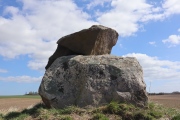
Neolithic and Bronze AgeSite Name: Menhir de Kercourtois 1Country: France Département: Bretagne:Côtes-D'Armor (22) Type: Standing Stone (Menhir)
Nearest Town: Carhaix-Plouger Nearest Village: St-Servais
Latitude: 48.379300N Longitude: 3.3769W
Condition:
| 5 | Perfect |
| 4 | Almost Perfect |
| 3 | Reasonable but with some damage |
| 2 | Ruined but still recognisable as an ancient site |
| 1 | Pretty much destroyed, possibly visible as crop marks |
| 0 | No data. |
| -1 | Completely destroyed |
| 5 | Superb |
| 4 | Good |
| 3 | Ordinary |
| 2 | Not Good |
| 1 | Awful |
| 0 | No data. |
| 5 | Can be driven to, probably with disabled access |
| 4 | Short walk on a footpath |
| 3 | Requiring a bit more of a walk |
| 2 | A long walk |
| 1 | In the middle of nowhere, a nightmare to find |
| 0 | No data. |
| 5 | co-ordinates taken by GPS or official recorded co-ordinates |
| 4 | co-ordinates scaled from a detailed map |
| 3 | co-ordinates scaled from a bad map |
| 2 | co-ordinates of the nearest village |
| 1 | co-ordinates of the nearest town |
| 0 | no data |
Be the first person to rate this site - see the 'Contribute!' box in the right hand menu.
Internal Links:
External Links:
")
Location Source: T4T35
You may be viewing yesterday's version of this page. To see the most up to date information please register for a free account.
")
Do not use the above information on other web sites or publications without permission of the contributor.
Nearby Images from Flickr
The above images may not be of the site on this page, but were taken nearby. They are loaded from Flickr so please click on them for image credits.
Click here to see more info for this site
Nearby sites
Click here to view sites on an interactive map of the areaKey: Red: member's photo, Blue: 3rd party photo, Yellow: other image, Green: no photo - please go there and take one, Grey: site destroyed
Download sites to:
KML (Google Earth)
GPX (GPS waypoints)
CSV (Garmin/Navman)
CSV (Excel)
To unlock full downloads you need to sign up as a Contributory Member. Otherwise downloads are limited to 50 sites.
Turn off the page maps and other distractions
Nearby sites listing. In the following links * = Image available
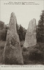
177m S 182° Menhir de Kercourtois 2* Standing Stone (Menhir)
267m SW 228° Dolmen dit la Roche de l'Ermite* Burial Chamber or Dolmen
318m NNW 348° Menhir de Kerroux Standing Stone (Menhir)
662m NW 314° Menhir Incliné* Standing Stone (Menhir)
728m NNW 339° Menhir de Saint-Servais Standing Stone (Menhir)
828m SW 217° Menhir dit la Dent de Saint-Servais* Standing Stone (Menhir)
1.0km NW 308° L'Ermite (St Servais)* Standing Stone (Menhir)
1.1km W 274° Menhirs dits Les Jumeaux* Standing Stones
1.4km SW 225° Menhir de Kerangler Standing Stone (Menhir)
1.5km SW 232° Toul an Urz allée couverte* Passage Grave
2.3km SSW 204° Menhir de Kerparquic Standing Stone (Menhir)
2.9km ENE 71° Menhir de Kernaëret* Standing Stone (Menhir)
3.4km S 183° Convenant Hoat Standing Stone (Menhir)
3.6km SSW 196° Menhirs de Kerhamon Standing Stone (Menhir)
3.6km S 188° Roudou Laerez menhir Standing Stone (Menhir)
3.9km S 186° Menhir des Gorges du Corong Standing Stone (Menhir)
5.0km S 179° Menhir Le Guellec* Standing Stones
5.3km S 171° Menhir Quélénec* Standing Stone (Menhir)
6.2km SSE 165° Menhir de Follezou Braz Standing Stone (Menhir)
6.2km SSE 161° Cupules du Bois de Follezou Sculptured Stone
6.3km ENE 73° Pierre de Coat-ar-Men-Sul Natural Stone / Erratic / Other Natural Feature
6.3km NNE 30° Fontaine des Sept Saints* Holy Well or Sacred Spring
6.3km NNE 30° Fontaine du Coq* Holy Well or Sacred Spring
6.4km SSE 162° Menhir du Bois de Follezou Standing Stone (Menhir)
6.5km E 93° Stèle de Kerroland* Standing Stone (Menhir)
View more nearby sites and additional images


 We would like to know more about this location. Please feel free to add a brief description and any relevant information in your own language.
 Wir möchten mehr über diese Stätte erfahren. Bitte zögern Sie nicht, eine kurze Beschreibung und relevante Informationen in Deutsch hinzuzufügen.
 Nous aimerions en savoir encore un peu sur les lieux. S'il vous plaît n'hesitez pas à ajouter une courte description et tous les renseignements pertinents dans votre propre langue.
 Quisieramos informarnos un poco más de las lugares. No dude en añadir una breve descripción y otros datos relevantes en su propio idioma.