

<< Our Photo Pages >> Manoir de Coadélan menhir - Standing Stone (Menhir) in France in Bretagne:Côtes-D'Armor (22)
Submitted by TheCaptain on Wednesday, 20 December 2023 Page Views: 3735
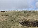
Neolithic and Bronze AgeSite Name: Manoir de Coadélan menhirCountry: France Département: Bretagne:Côtes-D'Armor (22) Type: Standing Stone (Menhir)
Nearest Town: Tréguier Nearest Village: Prat
Latitude: 48.695280N Longitude: 3.29144W
Condition:
| 5 | Perfect |
| 4 | Almost Perfect |
| 3 | Reasonable but with some damage |
| 2 | Ruined but still recognisable as an ancient site |
| 1 | Pretty much destroyed, possibly visible as crop marks |
| 0 | No data. |
| -1 | Completely destroyed |
| 5 | Superb |
| 4 | Good |
| 3 | Ordinary |
| 2 | Not Good |
| 1 | Awful |
| 0 | No data. |
| 5 | Can be driven to, probably with disabled access |
| 4 | Short walk on a footpath |
| 3 | Requiring a bit more of a walk |
| 2 | A long walk |
| 1 | In the middle of nowhere, a nightmare to find |
| 0 | No data. |
| 5 | co-ordinates taken by GPS or official recorded co-ordinates |
| 4 | co-ordinates scaled from a detailed map |
| 3 | co-ordinates scaled from a bad map |
| 2 | co-ordinates of the nearest village |
| 1 | co-ordinates of the nearest town |
| 0 | no data |
Internal Links:
External Links:
I have visited· I would like to visit
johnstone visited on 24th Jun 2023 - their rating: Cond: 4 Amb: 4 Access: 4
")
You may be viewing yesterday's version of this page. To see the most up to date information please register for a free account.
")
")
")
")
")
Do not use the above information on other web sites or publications without permission of the contributor.
Click here to see more info for this site
Nearby sites
Click here to view sites on an interactive map of the areaKey: Red: member's photo, Blue: 3rd party photo, Yellow: other image, Green: no photo - please go there and take one, Grey: site destroyed
Download sites to:
KML (Google Earth)
GPX (GPS waypoints)
CSV (Garmin/Navman)
CSV (Excel)
To unlock full downloads you need to sign up as a Contributory Member. Otherwise downloads are limited to 50 sites.
Turn off the page maps and other distractions
Nearby sites listing. In the following links * = Image available
5.6km NNE 17° Camp de Castel-Du Ancient Village or Settlement
7.0km S 172° Menhir de Kerguézennec* Standing Stone (Menhir)
7.1km ESE 121° Menhir de Camarel Standing Stone (Menhir)
7.7km N 3° Menhir de Kerfos Standing Stone (Menhir)
8.9km SE 134° Allée Couverte Ros Vras Passage Grave
9.1km SE 135° Menhir de Menou-Glas Standing Stone (Menhir)
9.5km S 184° Crec'h Coulm Menhir* Standing Stone (Menhir)
9.9km NNW 341° Menhir du Run* Standing Stone (Menhir)
10.4km SE 127° Menhirs de Kerdudalou* Standing Stones
11.2km N 354° Tossen-Keler Tumulus* Chambered Tomb
11.4km NNE 26° Tossen-Keler Cromlech (1964-2018)* Stone Circle
12.0km SW 235° Chapelle-des-Sept-Saints* Burial Chamber or Dolmen
12.1km ESE 122° Allée Couverte dite le Lit de Saint-Jean* Passage Grave
12.6km NNW 342° Coat Mez allée couverte* Passage Grave
13.0km NW 311° Dolmen dit le Lit de Saint-Yves* Burial Chamber or Dolmen
13.0km SE 132° Dolmen de Beuzil-Bras Burial Chamber or Dolmen
13.1km NNE 20° Menhir de Kerriou* Standing Stone (Menhir)
13.2km N 359° Kerpeulven Menhir (Penvénan)* Standing Stone (Menhir)
13.2km SSW 197° Pergat menhirs* Standing Stones
13.4km N 356° Menhir de Kerbriand* Standing Stone (Menhir)
13.9km WNW 283° Stèle de Saint-Patrice* Standing Stone (Menhir)
14.0km N 358° Menhir de Kermarker* Standing Stone (Menhir)
14.0km NW 307° Crec'h Quillé* Passage Grave
14.1km N 3° Tossen-Keler Cromlech (post 2018)* Stone Circle
14.1km N 3° Coffre de Roch Glaz* Cist
View more nearby sites and additional images


 We would like to know more about this location. Please feel free to add a brief description and any relevant information in your own language.
 Wir möchten mehr über diese Stätte erfahren. Bitte zögern Sie nicht, eine kurze Beschreibung und relevante Informationen in Deutsch hinzuzufügen.
 Nous aimerions en savoir encore un peu sur les lieux. S'il vous plaît n'hesitez pas à ajouter une courte description et tous les renseignements pertinents dans votre propre langue.
 Quisieramos informarnos un poco más de las lugares. No dude en añadir una breve descripción y otros datos relevantes en su propio idioma.