<< Our Photo Pages >> The Ebbing and Flowing Well - Holy Well or Sacred Spring in England in Yorkshire (North)
Submitted by vicky on Monday, 29 March 2004 Page Views: 7571
Springs and Holy WellsSite Name: The Ebbing and Flowing WellCountry: England County: Yorkshire (North) Type: Holy Well or Sacred Spring
Nearest Town: Giggleswick
Map Ref: SD80396538 Landranger Map Number: 98
Latitude: 54.083957N Longitude: 2.301251W
Condition:
| 5 | Perfect |
| 4 | Almost Perfect |
| 3 | Reasonable but with some damage |
| 2 | Ruined but still recognisable as an ancient site |
| 1 | Pretty much destroyed, possibly visible as crop marks |
| 0 | No data. |
| -1 | Completely destroyed |
| 5 | Superb |
| 4 | Good |
| 3 | Ordinary |
| 2 | Not Good |
| 1 | Awful |
| 0 | No data. |
| 5 | Can be driven to, probably with disabled access |
| 4 | Short walk on a footpath |
| 3 | Requiring a bit more of a walk |
| 2 | A long walk |
| 1 | In the middle of nowhere, a nightmare to find |
| 0 | No data. |
| 5 | co-ordinates taken by GPS or official recorded co-ordinates |
| 4 | co-ordinates scaled from a detailed map |
| 3 | co-ordinates scaled from a bad map |
| 2 | co-ordinates of the nearest village |
| 1 | co-ordinates of the nearest town |
| 0 | no data |
Be the first person to rate this site - see the 'Contribute!' box in the right hand menu.
Internal Links:
External Links:
")
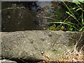
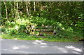
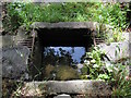
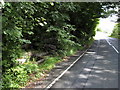
The Ebbing and Flowing Well sits at the foot of the precipitous Giggleswick Scar. Unfortunately, the B6479 passes right by it, spoiling the peace! The well got it's name from it's famous erratic behaviour; ebbing and flowing. The quarrying work nearby has also affected it's flow. Apparently the well supplies the water for the local church font.
The Northern Antiquarian (TNA) also features a page for this holy well - see their entry for Ebbing & Flowing Well, Giggleswick, North Yorkshire, which gives directions for finding the well together with an image of an early postcard, drawings, a current photograph and a brief archaeology & history and local folklore.
The Journal of Antiquities also features an entry for The Ebbing And Flowing Well, Giggleswick, North Yorkshire, which includes a photograph, directions for finding this well, and background information, which explores how the well was named: "When the well does flow it flows under the road to emerge in a wet, muddy mess, on the opposite side of the road and, sometimes flows over the road itself, but mostly it simply wells-up to fill its square-shaped stone chamber, and then without much warning drains-away and ‘goes back’ into the limestone scar – probably from one of the deep caves that is undoubtedly linked-up with the well somewhere along the way". The JoA also includes a list of reference sources for more information.
You may be viewing yesterday's version of this page. To see the most up to date information please register for a free account.
")
")
")
Do not use the above information on other web sites or publications without permission of the contributor.
Nearby Images from Geograph Britain and Ireland:
©2009(licence)

©2018(licence)
©2018(licence)
©2009(licence)
©2009(licence)
The above images may not be of the site on this page, they are loaded from Geograph.
Please Submit an Image of this site or go out and take one for us!
Click here to see more info for this site
Nearby sites
Key: Red: member's photo, Blue: 3rd party photo, Yellow: other image, Green: no photo - please go there and take one, Grey: site destroyed
Download sites to:
KML (Google Earth)
GPX (GPS waypoints)
CSV (Garmin/Navman)
CSV (Excel)
To unlock full downloads you need to sign up as a Contributory Member. Otherwise downloads are limited to 50 sites.
Turn off the page maps and other distractions
Nearby sites listing. In the following links * = Image available
853m NNE 18° Apronful of Stones (Giggleswick) Cairn (SD8065266193)
1.1km NNE 15° Sheep Scar Cairn (Giggleswick) Cairn (SD8067866436)
1.1km N 6° Sheep Scar Circle (Giggleswick) Ring Cairn (SD8051366473)
1.3km N 8° Feizor Thwaite Propped Stone* Rock Outcrop (SD8057466703)
1.7km SSE 148° Bank Well* Holy Well or Sacred Spring (SD813639)
2.0km N 351° Feizor Celtic Wall* Misc. Earthwork (SD8008067386)
2.2km NNW 344° Feizor Thwaite (Lawkland) Ring Cairn (SD79796747)
2.5km NW 315° Feizor (Lawkland) Standing Stone (Menhir) (SD78586718)
2.9km ENE 73° Samson's Toe (Langcliffe) Natural Stone / Erratic / Other Natural Feature (SD8317666229)
3.4km E 95° Albert Cave Cave or Rock Shelter (SD83796508)
3.4km E 96° Victoria Cave* Cave or Rock Shelter (SD838650)
3.5km ESE 102° Attermire Scar (Settle)* Rock Art (SD83836464)
4.3km SSE 157° Cleatop Park* Stone Circle (SD82056145)
6.0km NW 321° Norber Erratics Natural Stone / Erratic / Other Natural Feature (SD76597003)
6.4km ESE 109° Rye Loaf Hill (Settle) Cairn (SD8641963309)
6.9km SW 223° Brown Hills Beck* Round Barrow(s) (SD75616035)
7.0km SW 222° Brown Hills Beck East* Round Barrow(s) (SD75656025)
8.0km E 96° Ewe Moor* Ring Cairn (SD88326445)
8.4km E 98° Jorden Scar* Ancient Village or Settlement (SD88776419)
8.9km E 95° Ing Scar* Ancient Village or Settlement (SD8931964626)
9.0km E 93° Comb Scar* Ancient Village or Settlement (SD89366485)
9.4km E 90° Torlery Edge (Malham Moor) Ancient Village or Settlement (SD8978465292)
9.5km NNW 348° Skirtful of Stones (Ingleborough) Cairn (SD785747)
9.5km NNE 33° Giant's Graves (Halton Gill) Cairn (SD8564873346)
10.3km E 100° Malham settlements and field systems* Ancient Village or Settlement (SD905635)
View more nearby sites and additional images


 We would like to know more about this location. Please feel free to add a brief description and any relevant information in your own language.
 Wir möchten mehr über diese Stätte erfahren. Bitte zögern Sie nicht, eine kurze Beschreibung und relevante Informationen in Deutsch hinzuzufügen.
 Nous aimerions en savoir encore un peu sur les lieux. S'il vous plaît n'hesitez pas à ajouter une courte description et tous les renseignements pertinents dans votre propre langue.
 Quisieramos informarnos un poco más de las lugares. No dude en añadir una breve descripción y otros datos relevantes en su propio idioma.