<< Our Photo Pages >> St Drostan's Well - Holy Well or Sacred Spring in Scotland in Aberdeenshire
Submitted by vicky on Monday, 29 March 2004 Page Views: 15844
Springs and Holy WellsSite Name: St Drostan's WellCountry: Scotland County: Aberdeenshire Type: Holy Well or Sacred Spring
Nearest Village: New Aberdour
Map Ref: NJ887646 Landranger Map Number: 30
Latitude: 57.671129N Longitude: 2.191095W
Condition:
| 5 | Perfect |
| 4 | Almost Perfect |
| 3 | Reasonable but with some damage |
| 2 | Ruined but still recognisable as an ancient site |
| 1 | Pretty much destroyed, possibly visible as crop marks |
| 0 | No data. |
| -1 | Completely destroyed |
| 5 | Superb |
| 4 | Good |
| 3 | Ordinary |
| 2 | Not Good |
| 1 | Awful |
| 0 | No data. |
| 5 | Can be driven to, probably with disabled access |
| 4 | Short walk on a footpath |
| 3 | Requiring a bit more of a walk |
| 2 | A long walk |
| 1 | In the middle of nowhere, a nightmare to find |
| 0 | No data. |
| 5 | co-ordinates taken by GPS or official recorded co-ordinates |
| 4 | co-ordinates scaled from a detailed map |
| 3 | co-ordinates scaled from a bad map |
| 2 | co-ordinates of the nearest village |
| 1 | co-ordinates of the nearest town |
| 0 | no data |
Be the first person to rate this site - see the 'Contribute!' box in the right hand menu.
Internal Links:
External Links:
I have visited· I would like to visit
HaggisAction has visited here
")
KiwiBetsy writes:
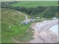
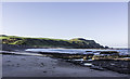
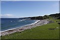
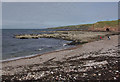
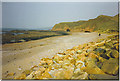
Heading east on the B9031 take a left turn (toward the sea) just before New Aberdour. The road passes Old Aberdour Church before ending in a carpark at the shingle beach. The well is just to the east of the carpark at the base of a hill. St Drostan used the water of this spring to baptise local people and was famed for his miracle cures. St Drostan died at Glenesk in 809AD. His remains were conveyed from Glenesk to Aberdour where they were placed in a stone coffin and long believed to work wondrous cures.
You may be viewing yesterday's version of this page. To see the most up to date information please register for a free account.
")
Do not use the above information on other web sites or publications without permission of the contributor.
coldrum has found this location on Google Street View:
Nearby Images from Geograph Britain and Ireland:
©2016(licence)
©2014(licence)
©2015(licence)
©2010(licence)
©2006(licence)
The above images may not be of the site on this page, they are loaded from Geograph.
Please Submit an Image of this site or go out and take one for us!
Click here to see more info for this site
Nearby sites
Key: Red: member's photo, Blue: 3rd party photo, Yellow: other image, Green: no photo - please go there and take one, Grey: site destroyed
Download sites to:
KML (Google Earth)
GPX (GPS waypoints)
CSV (Garmin/Navman)
CSV (Excel)
To unlock full downloads you need to sign up as a Contributory Member. Otherwise downloads are limited to 50 sites.
Turn off the page maps and other distractions
Nearby sites listing. In the following links * = Image available
537m WNW 292° Mess John's Well Holy Well or Sacred Spring (NJ882648)
822m ENE 76° Dundarg Castle* Hillfort (NJ895648)
3.5km ENE 74° Gallows Hill (The Hanging Stone) Standing Stone (Menhir) (NJ9211465539)
4.4km W 259° Cummerton Cairn (NJ844638)
4.5km ESE 109° Tyrie Class I Pictish Symbol Stone (NJ93006310)
4.8km W 260° Litterty Hill* Cairn (NJ840638)
5.2km WNW 288° Cullykhan * Promontory Fort / Cliff Castle (NJ83756618)
5.5km S 185° Law Cairn* Cairn (NJ88205911)
5.5km SW 234° Strath Howe Hillfort (NJ842614)
6.0km SW 231° Glenhouses Hut Circles Ancient Village or Settlement (NJ840608)
6.2km SE 144° Picts House* Misc. Earthwork (NJ92365963)
9.3km W 267° Castle of Findon Hillfort (NJ794642)
9.3km ESE 106° Memsie Burial Cairn* Cairn (NJ97666205)
9.6km SSW 210° Upper Auchnagorth* Stone Circle (NJ8391156272)
10.8km WSW 236° Gray Stone (Clochforbie)* Stone Circle (NJ79685863)
11.2km SSE 154° Strichen House* Stone Circle (NJ93675449)
13.0km W 268° Law of Melrose* Cairn (NJ75666426)
13.4km ESE 113° Cortie Brae* Stone Circle (NK01015924)
13.6km W 262° Cairn Lee* Cairn (NJ75136284)
14.0km SSE 155° White Cow Wood* Chambered Cairn (NJ947519)
15.0km WSW 247° Law of Balgreen* Cairn (NJ74815887)
15.2km W 260° Longmanhill Cairn Long Barrow (NJ73726200)
15.4km SSE 157° Auchmachar Long Cairn* Cairn (NJ9461850314)
15.4km SSE 157° Knapperty Hill* Chambered Cairn (NJ946503)
15.5km SSE 157° Auchmachar* Stone Circle (NJ948503)
View more nearby sites and additional images


 We would like to know more about this location. Please feel free to add a brief description and any relevant information in your own language.
 Wir möchten mehr über diese Stätte erfahren. Bitte zögern Sie nicht, eine kurze Beschreibung und relevante Informationen in Deutsch hinzuzufügen.
 Nous aimerions en savoir encore un peu sur les lieux. S'il vous plaît n'hesitez pas à ajouter une courte description et tous les renseignements pertinents dans votre propre langue.
 Quisieramos informarnos un poco más de las lugares. No dude en añadir una breve descripción y otros datos relevantes en su propio idioma.