

<< Our Photo Pages >> Knocking Knoll - Long Barrow in England in Hertfordshire
Submitted by bec-zog on Friday, 26 March 2004 Page Views: 12187
Neolithic and Bronze AgeSite Name: Knocking KnollCountry: England County: Hertfordshire Type: Long Barrow
Nearest Town: Hitchin Nearest Village: Pegsdon
Map Ref: TL133310 Landranger Map Number: 166
Latitude: 51.965940N Longitude: 0.352267W
Condition:
| 5 | Perfect |
| 4 | Almost Perfect |
| 3 | Reasonable but with some damage |
| 2 | Ruined but still recognisable as an ancient site |
| 1 | Pretty much destroyed, possibly visible as crop marks |
| 0 | No data. |
| -1 | Completely destroyed |
| 5 | Superb |
| 4 | Good |
| 3 | Ordinary |
| 2 | Not Good |
| 1 | Awful |
| 0 | No data. |
| 5 | Can be driven to, probably with disabled access |
| 4 | Short walk on a footpath |
| 3 | Requiring a bit more of a walk |
| 2 | A long walk |
| 1 | In the middle of nowhere, a nightmare to find |
| 0 | No data. |
| 5 | co-ordinates taken by GPS or official recorded co-ordinates |
| 4 | co-ordinates scaled from a detailed map |
| 3 | co-ordinates scaled from a bad map |
| 2 | co-ordinates of the nearest village |
| 1 | co-ordinates of the nearest town |
| 0 | no data |
Internal Links:
External Links:
I have visited· I would like to visit
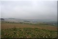
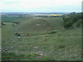
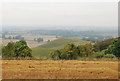
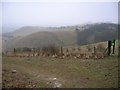
Brian_Eyes visited on 31st Dec 2018 - their rating: Cond: 3 Amb: 5 Access: 3 On a high exposed hill with particularly long views to E and W. What remains of the barrow is quite circular but long, more tapering west facing side and ploughed field just behind the East side suggest it could originally have been elongated along E-W axis.
Apparently the barrow straddles the border between Bedfordshire and Hertfordshire which could be the reason that the E end is more ploughed out.
Historic England website records it as a bowl barrow, but the Pastscape website suggests that it is a long barrow that has been damaged by ploughing.
")
Knocking Knoll long barrow is located near Pegsdon on county border and is partially damaged by ploughing. It is 4.4 m in height and has been excavated in 1856 (inhumation burial and an urn were discovered).
You may be viewing yesterday's version of this page. To see the most up to date information please register for a free account.
")
")
Do not use the above information on other web sites or publications without permission of the contributor.
Nearby Images from Geograph Britain and Ireland:
©2007(licence)
©2015(licence)
©2014(licence)
©2011(licence)
©2017(licence)
The above images may not be of the site on this page, they are loaded from Geograph.
Please Submit an Image of this site or go out and take one for us!
Click here to see more info for this site
Nearby sites
Key: Red: member's photo, Blue: 3rd party photo, Yellow: other image, Green: no photo - please go there and take one, Grey: site destroyed
Download sites to:
KML (Google Earth)
GPX (GPS waypoints)
CSV (Garmin/Navman)
CSV (Excel)
To unlock full downloads you need to sign up as a Contributory Member. Otherwise downloads are limited to 50 sites.
Turn off the page maps and other distractions
Nearby sites listing. In the following links * = Image available
528m S 188° Tingley Field Plantation Round Barrow* Round Barrow(s) (TL1324030475)
1.4km SSW 212° Deacon Hill* Hillfort (TL12602982)
2.8km SW 216° Telegraph Hill (Lilley Hoo) Bowl Barrow Round Barrow(s) (TL117287)
3.1km WSW 258° St Faith's Well* Holy Well or Sacred Spring (TL103303)
3.7km WSW 247° Ravensburgh Castle* Hillfort (TL099295)
5.3km ESE 110° North Herts Museum* Museum (TL18342926)
5.7km SW 227° Galley Hill (Streatley)* Round Barrow(s) (TL092270)
6.5km SW 227° Dray's Ditches* Misc. Earthwork (TL08642641)
6.6km WSW 257° Sharpenhoe Burial Mound* Round Barrow(s)
6.8km W 266° Sharpenhoe Clappers* Hillfort (TL065304)
7.0km E 79° Wilbury Hill* Hillfort (TL202325)
8.9km ESE 112° Priory Well (Hertfordshire)* Holy Well or Sacred Spring (TL217279)
9.2km NE 42° Etonbury Fort* Hillfort (TL1929637984)
9.5km SW 230° Waulud's Bank* Henge (TL062247)
10.3km ENE 74° Norton Henge Henge (TL232341)
11.1km ENE 73° Letchworth Cursus Cursus (TL239344)
12.3km NW 322° Houghton Conquest Long Barrow (TL055405)
12.3km E 87° Weston Hill Henge* Henge (TL256319)
12.3km W 262° Conger Hill* Hillfort (TL011289)
12.7km SE 127° Six Hills* Round Barrow(s) (TL23742365)
13.5km ENE 76° Barrows under A505 Barrow Cemetery (TL264346)
14.7km ENE 59° Arbury Banks Barrow/hut circle Round Barrow(s) (TL2584638770)
15.0km ENE 60° Arbury Banks (Hertfordshire)* Hillfort (TL262387)
15.1km ENE 72° Bygrave Barrows Barrow Cemetery (TL2759935981)
15.4km ENE 78° Tree Barrow Round Barrow(s) (TL2831834612)
View more nearby sites and additional images


 We would like to know more about this location. Please feel free to add a brief description and any relevant information in your own language.
 Wir möchten mehr über diese Stätte erfahren. Bitte zögern Sie nicht, eine kurze Beschreibung und relevante Informationen in Deutsch hinzuzufügen.
 Nous aimerions en savoir encore un peu sur les lieux. S'il vous plaît n'hesitez pas à ajouter une courte description et tous les renseignements pertinents dans votre propre langue.
 Quisieramos informarnos un poco más de las lugares. No dude en añadir una breve descripción y otros datos relevantes en su propio idioma.