

<< Text Pages >> Dolmen des Serres de Bernard 1 - Burial Chamber or Dolmen in France in Rhone:Ardèche (07)
Submitted by TheCaptain on Friday, 06 May 2011 Page Views: 1580
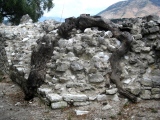
Neolithic and Bronze AgeSite Name: Dolmen des Serres de Bernard 1 Alternative Name: Serre de BernardCountry: France Département: Rhone:Ardèche (07) Type: Burial Chamber or Dolmen
Nearest Town: Ales Nearest Village: Chandolas
Latitude: 44.409630N Longitude: 4.238410E
Condition:
| 5 | Perfect |
| 4 | Almost Perfect |
| 3 | Reasonable but with some damage |
| 2 | Ruined but still recognisable as an ancient site |
| 1 | Pretty much destroyed, possibly visible as crop marks |
| 0 | No data. |
| -1 | Completely destroyed |
| 5 | Superb |
| 4 | Good |
| 3 | Ordinary |
| 2 | Not Good |
| 1 | Awful |
| 0 | No data. |
| 5 | Can be driven to, probably with disabled access |
| 4 | Short walk on a footpath |
| 3 | Requiring a bit more of a walk |
| 2 | A long walk |
| 1 | In the middle of nowhere, a nightmare to find |
| 0 | No data. |
| 5 | co-ordinates taken by GPS or official recorded co-ordinates |
| 4 | co-ordinates scaled from a detailed map |
| 3 | co-ordinates scaled from a bad map |
| 2 | co-ordinates of the nearest village |
| 1 | co-ordinates of the nearest town |
| 0 | no data |
Be the first person to rate this site - see the 'Contribute!' box in the right hand menu.
Internal Links:
External Links:
burial chamber in Rhone-Alpes:Ardeche
Serre de Bernard is a burial chamber in the community of Chandolas, Departement of Ardeche, Region of Rhone-Alpes
You may be viewing yesterday's version of this page. To see the most up to date information please register for a free account.
Do not use the above information on other web sites or publications without permission of the contributor.
Nearby Images from Flickr


The above images may not be of the site on this page, but were taken nearby. They are loaded from Flickr so please click on them for image credits.
Click here to see more info for this site
Nearby sites
Click here to view sites on an interactive map of the areaKey: Red: member's photo, Blue: 3rd party photo, Yellow: other image, Green: no photo - please go there and take one, Grey: site destroyed
Download sites to:
KML (Google Earth)
GPX (GPS waypoints)
CSV (Garmin/Navman)
CSV (Excel)
To unlock full downloads you need to sign up as a Contributory Member. Otherwise downloads are limited to 50 sites.
Turn off the page maps and other distractions
Nearby sites listing. In the following links * = Image available
400m W 273° Dolmen des Serres de Bernard 2 Burial Chamber or Dolmen
972m W 273° Dolmen du Mas des Rondels Burial Chamber or Dolmen
997m WNW 296° Dolmen de Cognas Burial Chamber or Dolmen
1.9km E 82° Dolmen du Ranc d'Aven 3* Burial Chamber or Dolmen
1.9km E 84° Dolmen du Ranc d'Aven 2* Burial Chamber or Dolmen
1.9km E 82° Coffre du Ranc d'Aven Cist
2.1km E 86° Dolmen du Ranc d'Aven 1* Burial Chamber or Dolmen
2.4km NNW 339° Dolmen des Blaches 1 Burial Chamber or Dolmen
2.4km NNW 337° Dolmen des Blaches 2 Burial Chamber or Dolmen
2.5km NE 35° Dolmen du Blachas Burial Chamber or Dolmen
2.6km NNE 30° Dolmen du Bois de Chabanet Burial Chamber or Dolmen
2.6km NNE 15° Dolmen de Raoux 2 Burial Chamber or Dolmen
2.7km NNE 33° Dolmen du Gour de l'Estang 1* Burial Chamber or Dolmen
2.7km NNE 25° Dolmen de Raoux 1 Burial Chamber or Dolmen
2.7km WNW 299° Dolmen de la Blache 1 Burial Chamber or Dolmen
2.7km NE 36° Dolmen du Gour de l'Estang 2* Burial Chamber or Dolmen
2.8km WNW 298° Dolmen de la Blache 2 Burial Chamber or Dolmen
2.8km NNE 33° Dolmen de Flandrin (11) Burial Chamber or Dolmen
2.8km NE 43° Font Mejanne dolmen 4* Burial Chamber or Dolmen
2.9km NE 46° Font Mejanne dolmen1* Burial Chamber or Dolmen
2.9km NNE 32° Dolmen de Flandrin (10)* Burial Chamber or Dolmen
2.9km NE 45° Font Mejanne dolmen 2* Burial Chamber or Dolmen
2.9km WNW 289° Dolmen de la Blache 3 Burial Chamber or Dolmen
3.0km NE 43° Font Mejanne dolmen 3* Burial Chamber or Dolmen
3.0km NNE 26° Dolmen de Flandrin (05)* Burial Chamber or Dolmen
View more nearby sites and additional images


 We would like to know more about this location. Please feel free to add a brief description and any relevant information in your own language.
 Wir möchten mehr über diese Stätte erfahren. Bitte zögern Sie nicht, eine kurze Beschreibung und relevante Informationen in Deutsch hinzuzufügen.
 Nous aimerions en savoir encore un peu sur les lieux. S'il vous plaît n'hesitez pas à ajouter une courte description et tous les renseignements pertinents dans votre propre langue.
 Quisieramos informarnos un poco más de las lugares. No dude en añadir una breve descripción y otros datos relevantes en su propio idioma.