


<< Our Photo Pages >> Dolmen de Marcilly - Burial Chamber or Dolmen in France in Centre:Indre-et-Loire (37)
Submitted by TheCaptain on Wednesday, 08 September 2010 Page Views: 2590
Neolithic and Bronze AgeSite Name: Dolmen de Marcilly Alternative Name: dolmen de LucéCountry: France Département: Centre:Indre-et-Loire (37) Type: Burial Chamber or Dolmen
Nearest Town: Tours Nearest Village: Neuillé Pont-de-Pierre
Latitude: 47.575700N Longitude: 0.519900E
Condition:
| 5 | Perfect |
| 4 | Almost Perfect |
| 3 | Reasonable but with some damage |
| 2 | Ruined but still recognisable as an ancient site |
| 1 | Pretty much destroyed, possibly visible as crop marks |
| 0 | No data. |
| -1 | Completely destroyed |
| 5 | Superb |
| 4 | Good |
| 3 | Ordinary |
| 2 | Not Good |
| 1 | Awful |
| 0 | No data. |
| 5 | Can be driven to, probably with disabled access |
| 4 | Short walk on a footpath |
| 3 | Requiring a bit more of a walk |
| 2 | A long walk |
| 1 | In the middle of nowhere, a nightmare to find |
| 0 | No data. |
| 5 | co-ordinates taken by GPS or official recorded co-ordinates |
| 4 | co-ordinates scaled from a detailed map |
| 3 | co-ordinates scaled from a bad map |
| 2 | co-ordinates of the nearest village |
| 1 | co-ordinates of the nearest town |
| 0 | no data |
Internal Links:
External Links:
I have visited· I would like to visit
TheCaptain visited on 11th Aug 2005 - their rating: Cond: 4 Amb: 4 Access: 3 This was not an easy dolmen to get to, as my campervan wouldn’t go under a low railway bridge, and hence I had a walk of over a kilometre. It's hard to explain, but once under the railway I just followed the field edges hoping to see something, and there it was, beyond a copse and a pond.
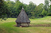
The dolmen is a fairly simple thing, with a single capstone sat on top of three support stones, making a rectangular chamber of 3m by 2.5m. Whether there was ever any more to it or not I don't know. It's all leaning a bit these days, and sat on a little mound. Nice. I thought I wouldn't get this one.
")
The dolmen is a fairly simple thing, with a single capstone sat on top of three support stones, making a rectangular chamber of 3m by 2.5m. Whether there was ever any more to it or not I don't know. It's all leaning a bit these days, and sat on a little mound.
Nice. I thought I wouldn't get this one.
You may be viewing yesterday's version of this page. To see the most up to date information please register for a free account.
")
")
")
Do not use the above information on other web sites or publications without permission of the contributor.
Nearby Images from Flickr
The above images may not be of the site on this page, but were taken nearby. They are loaded from Flickr so please click on them for image credits.
Click here to see more info for this site
Nearby sites
Click here to view sites on an interactive map of the areaKey: Red: member's photo, Blue: 3rd party photo, Yellow: other image, Green: no photo - please go there and take one, Grey: site destroyed
Download sites to:
KML (Google Earth)
GPX (GPS waypoints)
CSV (Garmin/Navman)
CSV (Excel)
To unlock full downloads you need to sign up as a Contributory Member. Otherwise downloads are limited to 50 sites.
Turn off the page maps and other distractions
Nearby sites listing. In the following links * = Image available
853m WSW 252° Pierre Levée (La Grange)* Standing Stone (Menhir)
3.9km NW 318° Polissoir D’Hodebert Polissoir
4.0km NW 317° Menhir de la grande Saint Martin Standing Stone (Menhir)
6.5km ENE 61° Polissoir du Bois du Gué Polissoir
7.8km E 96° Dolmen de la Haute Barde* Burial Chamber or Dolmen
8.6km E 99° Pierre du Pont-Champion* Standing Stone (Menhir)
9.3km N 1° Menhir de Haute Crêne Standing Stone (Menhir)
9.3km W 264° La Pierre Saint Martin* Polissoir
11.5km NNW 346° Pierre Levée (Dissay) Standing Stone (Menhir)
12.3km N 349° Pierre Vouze Standing Stone (Menhir)
12.4km NE 34° La Pierre du Supplice Standing Stone (Menhir)
14.4km WSW 253° La Pierre de Vaujour* Standing Stone (Menhir)
14.6km W 275° Dolmen de la Pierre Levée (Villiers-au-Bouin) Burial Chamber or Dolmen
15.1km NNE 15° Dolmen du Petit Hêtre Burial Chamber or Dolmen
15.9km SE 125° Menhir dit la Grosse Pierre (Cérelles) Standing Stone (Menhir)
15.9km SE 142° La Grotte aux Fées* Burial Chamber or Dolmen
16.1km ESE 106° Menhir de la Pierre à Vinaigre Standing Stone (Menhir)
16.4km SE 145° Menhir de Toulifault Standing Stone (Menhir)
16.8km NNE 29° Menhir des Cormiers Standing Stone (Menhir)
17.9km SE 130° Polissoir du Bois de Baudry Polissoir
18.7km N 353° Gobiane Menhir* Standing Stone (Menhir)
18.9km NNE 33° Menhir de Bouillant Standing Stone (Menhir)
19.0km N 352° Menhir des Ventes Standing Stone (Menhir)
19.9km NW 313° Dolmen dit Pierre Couverte de Vaas Burial Chamber or Dolmen
21.1km WNW 289° Amenon Dolmen* Burial Chamber or Dolmen
View more nearby sites and additional images


 We would like to know more about this location. Please feel free to add a brief description and any relevant information in your own language.
 Wir möchten mehr über diese Stätte erfahren. Bitte zögern Sie nicht, eine kurze Beschreibung und relevante Informationen in Deutsch hinzuzufügen.
 Nous aimerions en savoir encore un peu sur les lieux. S'il vous plaît n'hesitez pas à ajouter une courte description et tous les renseignements pertinents dans votre propre langue.
 Quisieramos informarnos un poco más de las lugares. No dude en añadir una breve descripción y otros datos relevantes en su propio idioma.