

<< Text Pages >> Retamar 3 - Burial Chamber or Dolmen in Spain in Extremadura
Submitted by TheCaptain on Wednesday, 08 September 2010 Page Views: 1091
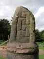
Neolithic and Bronze AgeSite Name: Retamar 3Country: Spain Region: Extremadura Type: Burial Chamber or Dolmen
Nearest Town: Caceres Nearest Village: Alcantara
Latitude: 39.757800N Longitude: 6.9528W
Condition:
| 5 | Perfect |
| 4 | Almost Perfect |
| 3 | Reasonable but with some damage |
| 2 | Ruined but still recognisable as an ancient site |
| 1 | Pretty much destroyed, possibly visible as crop marks |
| 0 | No data. |
| -1 | Completely destroyed |
| 5 | Superb |
| 4 | Good |
| 3 | Ordinary |
| 2 | Not Good |
| 1 | Awful |
| 0 | No data. |
| 5 | Can be driven to, probably with disabled access |
| 4 | Short walk on a footpath |
| 3 | Requiring a bit more of a walk |
| 2 | A long walk |
| 1 | In the middle of nowhere, a nightmare to find |
| 0 | No data. |
| 5 | co-ordinates taken by GPS or official recorded co-ordinates |
| 4 | co-ordinates scaled from a detailed map |
| 3 | co-ordinates scaled from a bad map |
| 2 | co-ordinates of the nearest village |
| 1 | co-ordinates of the nearest town |
| 0 | no data |
Be the first person to rate this site - see the 'Contribute!' box in the right hand menu.
Internal Links:
External Links:
Burial chamber in Extremadura
Retamar 3 is a burial chamber in the community of Alcantara, Province of Caceres, region of Extremadura
You may be viewing yesterday's version of this page. To see the most up to date information please register for a free account.
Do not use the above information on other web sites or publications without permission of the contributor.
Click here to see more info for this site
Nearby sites
Click here to view sites on an interactive map of the areaKey: Red: member's photo, Blue: 3rd party photo, Yellow: other image, Green: no photo - please go there and take one, Grey: site destroyed
Download sites to:
KML (Google Earth)
GPX (GPS waypoints)
CSV (Garmin/Navman)
CSV (Excel)
To unlock full downloads you need to sign up as a Contributory Member. Otherwise downloads are limited to 50 sites.
Turn off the page maps and other distractions
Nearby sites listing. In the following links * = Image available
42m NW 322° Retamar 4 Burial Chamber or Dolmen
61m ESE 123° Retamar 2 Burial Chamber or Dolmen
115m SE 125° Retamar 1 Burial Chamber or Dolmen
475m NNW 327° Cerro Conejo 1 Burial Chamber or Dolmen
590m N 358° Cerro Conejo 2 Burial Chamber or Dolmen
1.6km SW 217° Carbonero Burial Chamber or Dolmen
1.8km N 359° El Santo* Burial Chamber or Dolmen
2.8km ENE 73° La Llorona Burial Chamber or Dolmen
3.1km E 93° Menhir del Cabezo* Standing Stone (Menhir)
3.4km E 92° El Cabezo Burial Chamber or Dolmen
4.1km NNW 331° Barcollero Burial Chamber or Dolmen
4.1km NE 48° El Torruco Burial Chamber or Dolmen
4.5km ENE 78° Noguer Burial Chamber or Dolmen
4.8km S 191° Cornejo Burial Chamber or Dolmen
4.9km NNW 339° El Pizarron* Burial Chamber or Dolmen
5.1km SSW 212° Moheda Burial Chamber or Dolmen
6.6km SE 127° Baldio San Miguel Burial Chamber or Dolmen
6.7km SE 127° Marvanes Burial Chamber or Dolmen
7.4km SSW 195° San Martin Burial Chamber or Dolmen
7.5km SSW 196° Calderones Burial Chamber or Dolmen
7.7km S 180° Castro de Morros de la Novillada Castro or Chafurdão
9.1km S 184° Trincones 3 Burial Chamber or Dolmen
9.6km S 182° Trincones 2 Burial Chamber or Dolmen
10.6km ESE 106° Carrascal 1* Burial Chamber or Dolmen
10.7km SE 133° Fraila Burial Chamber or Dolmen
View more nearby sites and additional images


 We would like to know more about this location. Please feel free to add a brief description and any relevant information in your own language.
 Wir möchten mehr über diese Stätte erfahren. Bitte zögern Sie nicht, eine kurze Beschreibung und relevante Informationen in Deutsch hinzuzufügen.
 Nous aimerions en savoir encore un peu sur les lieux. S'il vous plaît n'hesitez pas à ajouter une courte description et tous les renseignements pertinents dans votre propre langue.
 Quisieramos informarnos un poco más de las lugares. No dude en añadir una breve descripción y otros datos relevantes en su propio idioma.