

<< Our Photo Pages >> Vellerup Marker Jættestue - Passage Grave in Denmark in Hovedstaden
Submitted by kristiansen on Thursday, 10 June 2010 Page Views: 2633
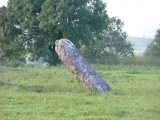
Neolithic and Bronze AgeSite Name: Vellerup Marker Jættestue Alternative Name: NissehøjCountry: Denmark County: Hovedstaden Type: Passage Grave
Nearest Town: København Nearest Village: Vellerup
Latitude: 55.748553N Longitude: 11.880145E
Condition:
| 5 | Perfect |
| 4 | Almost Perfect |
| 3 | Reasonable but with some damage |
| 2 | Ruined but still recognisable as an ancient site |
| 1 | Pretty much destroyed, possibly visible as crop marks |
| 0 | No data. |
| -1 | Completely destroyed |
| 5 | Superb |
| 4 | Good |
| 3 | Ordinary |
| 2 | Not Good |
| 1 | Awful |
| 0 | No data. |
| 5 | Can be driven to, probably with disabled access |
| 4 | Short walk on a footpath |
| 3 | Requiring a bit more of a walk |
| 2 | A long walk |
| 1 | In the middle of nowhere, a nightmare to find |
| 0 | No data. |
| 5 | co-ordinates taken by GPS or official recorded co-ordinates |
| 4 | co-ordinates scaled from a detailed map |
| 3 | co-ordinates scaled from a bad map |
| 2 | co-ordinates of the nearest village |
| 1 | co-ordinates of the nearest town |
| 0 | no data |
Internal Links:
External Links:
")
More information at www.kulturarv.dk: Danish Sites and Monuments Record: 010209-19
"Fortidsmindedata Copyright Kulturarvsstyrelsen"
You may be viewing yesterday's version of this page. To see the most up to date information please register for a free account.
")
")
")
")
")
")
")
")
")
Do not use the above information on other web sites or publications without permission of the contributor.
Click here to see more info for this site
Nearby sites
Click here to view sites on an interactive map of the areaKey: Red: member's photo, Blue: 3rd party photo, Yellow: other image, Green: no photo - please go there and take one, Grey: site destroyed
Download sites to:
KML (Google Earth)
GPX (GPS waypoints)
CSV (Garmin/Navman)
CSV (Excel)
To unlock full downloads you need to sign up as a Contributory Member. Otherwise downloads are limited to 50 sites.
Turn off the page maps and other distractions
Nearby sites listing. In the following links * = Image available
642m N 3° Klingerbakke Jættestue* Passage Grave
1.6km NNW 333° Vejleby Marker Langdysse* Long Barrow
1.8km WNW 292° Vejleby Hammer Bakke Hellekiste* Cist
2.0km SSE 169° Skruthøj Egholm Skov* Round Barrow(s)
2.4km NNW 338° Sandager Dys* Burial Chamber or Dolmen
2.4km SSW 207° Kyndeløse Nordmark Runddysse* Burial Chamber or Dolmen
2.4km S 186° Nørre Hyllinge Langdysse* Long Barrow
2.9km NNW 345° Vejleby Marker Runddysse* Burial Chamber or Dolmen
3.0km N 6° Venslev Marker Langdysse 1* Long Barrow
3.1km NE 36° Ladager Dysse* Long Barrow
3.1km SSE 159° Nørre Hyllinge Jættestue* Passage Grave
3.3km NE 45° Ferslev Marker* Standing Stones
3.4km NE 36° Venslev Marker Megalitgrav 3* Burial Chamber or Dolmen
3.4km N 4° Venslev Marker Runddysse 2* Burial Chamber or Dolmen
4.0km NE 35° Venslev Marker Megalitgrav 1* Burial Chamber or Dolmen
4.0km NE 34° Venslev Marker Megalitgrav 2* Burial Chamber or Dolmen
4.1km N 354° Venslev Marker Runddysse 1* Burial Chamber or Dolmen
4.3km NNE 16° Venslev Marker Jættestue 3* Passage Grave
4.4km N 352° Venslev Marker Langdysse 2* Long Barrow
4.6km N 7° Venslev Marker Jættestue 2* Passage Grave
4.6km N 1° Orkenspends Dys Jættestue* Passage Grave
4.6km N 2° Venslev Marker Jættestue 1* Passage Grave
4.6km N 360° Maredys Jættestue* Passage Grave
4.6km E 80° Skibby Marker Jættestue* Passage Grave
5.0km NW 326° Orøstenen* Natural Stone / Erratic / Other Natural Feature
View more nearby sites and additional images


 We would like to know more about this location. Please feel free to add a brief description and any relevant information in your own language.
 Wir möchten mehr über diese Stätte erfahren. Bitte zögern Sie nicht, eine kurze Beschreibung und relevante Informationen in Deutsch hinzuzufügen.
 Nous aimerions en savoir encore un peu sur les lieux. S'il vous plaît n'hesitez pas à ajouter une courte description et tous les renseignements pertinents dans votre propre langue.
 Quisieramos informarnos un poco más de las lugares. No dude en añadir una breve descripción y otros datos relevantes en su propio idioma.