

<< Our Photo Pages >> Trespalous menhir 2 - Standing Stone (Menhir) in France in Languedoc:Gard (30)
Submitted by TheCaptain on Saturday, 16 April 2005 Page Views: 2884
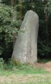
Neolithic and Bronze AgeSite Name: Trespalous menhir 2 Alternative Name: Trepaloup menhir 2Country: France Département: Languedoc:Gard (30) Type: Standing Stone (Menhir)
Nearest Town: Le Vigan Nearest Village: Prat-Peyrot
Latitude: 44.119000N Longitude: 3.588000E
Condition:
| 5 | Perfect |
| 4 | Almost Perfect |
| 3 | Reasonable but with some damage |
| 2 | Ruined but still recognisable as an ancient site |
| 1 | Pretty much destroyed, possibly visible as crop marks |
| 0 | No data. |
| -1 | Completely destroyed |
| 5 | Superb |
| 4 | Good |
| 3 | Ordinary |
| 2 | Not Good |
| 1 | Awful |
| 0 | No data. |
| 5 | Can be driven to, probably with disabled access |
| 4 | Short walk on a footpath |
| 3 | Requiring a bit more of a walk |
| 2 | A long walk |
| 1 | In the middle of nowhere, a nightmare to find |
| 0 | No data. |
| 5 | co-ordinates taken by GPS or official recorded co-ordinates |
| 4 | co-ordinates scaled from a detailed map |
| 3 | co-ordinates scaled from a bad map |
| 2 | co-ordinates of the nearest village |
| 1 | co-ordinates of the nearest town |
| 0 | no data |
Internal Links:
External Links:
I have visited· I would like to visit
johnstone visited on 2nd Jul 2008 - their rating: Cond: 4 Amb: 3 Access: 4
regina have visited here
")
1.8 metres tall
IMPORTANT NOTE: Site believed to be near this position
You may be viewing yesterday's version of this page. To see the most up to date information please register for a free account.
")
")
")
")
Do not use the above information on other web sites or publications without permission of the contributor.
Nearby Images from Flickr
The above images may not be of the site on this page, but were taken nearby. They are loaded from Flickr so please click on them for image credits.
Click here to see more info for this site
Nearby sites
Click here to view sites on an interactive map of the areaKey: Red: member's photo, Blue: 3rd party photo, Yellow: other image, Green: no photo - please go there and take one, Grey: site destroyed
Download sites to:
KML (Google Earth)
GPX (GPS waypoints)
CSV (Garmin/Navman)
CSV (Excel)
To unlock full downloads you need to sign up as a Contributory Member. Otherwise downloads are limited to 50 sites.
Turn off the page maps and other distractions
Nearby sites listing. In the following links * = Image available
86m NW 310° Trespalous menhir 1* Standing Stone (Menhir)
5.2km WSW 240° Col de Pierre Plantée* Standing Stone (Menhir)
6.9km E 89° Col de l'Espinas Dolmen* Burial Chamber or Dolmen
8.4km W 266° Menhir de Camprieu* Standing Stone (Menhir)
9.0km SSE 155° Dolmen de Col-de-Peyrefiche Standing Stone (Menhir)
9.2km NNE 18° Menhirs des Crottes 2 Standing Stone (Menhir)
9.3km ESE 111° Menhir de Bonperrier Standing Stone (Menhir)
9.7km NNE 18° Menhirs des Crottes 1 Standing Stone (Menhir)
9.7km NW 325° Menhir du Col de Fourques* Standing Stone (Menhir)
9.8km SSE 154° Serre-de-Rouas menhirs* Standing Stones
10.1km SE 126° Menhir d'Ardaillès* Standing Stone (Menhir)
10.2km NNE 24° Bout-de-la-Côte Menhir* Standing Stone (Menhir)
10.2km N 8° Menhir de Peyrebesse Standing Stone (Menhir)
10.6km ENE 60° Rougeiresque menhir* Standing Stone (Menhir)
10.6km NNE 20° Montjoie de la Can de l'Hospitalet D* Marker Stone
10.8km NNE 18° Montjoie de la Can de l'Hospitalet C* Marker Stone
10.9km NNE 26° Col de Tartabissac menhir* Standing Stone (Menhir)
11.0km NNE 16° Montjoie de la Can de l'Hospitalet B* Marker Stone
11.4km NNE 15° Montjoie de la Can de l'Hospitalet A* Marker Stone
12.4km NW 322° Menhirs de Gatuzières* Stone Row / Alignment
13.1km NNW 341° Dolmen de Devois de Villeneuve Burial Chamber or Dolmen
13.2km NW 324° Grand Dolmen Aures * Chambered Tomb
13.4km NNW 340° Chaos de Nîmes-le-Vieux* Rock Outcrop
13.5km ESE 121° Col de Bès Menhir* Standing Stone (Menhir)
13.7km N 10° Menhir du Col de Solperiére* Standing Stone (Menhir)
View more nearby sites and additional images


 We would like to know more about this location. Please feel free to add a brief description and any relevant information in your own language.
 Wir möchten mehr über diese Stätte erfahren. Bitte zögern Sie nicht, eine kurze Beschreibung und relevante Informationen in Deutsch hinzuzufügen.
 Nous aimerions en savoir encore un peu sur les lieux. S'il vous plaît n'hesitez pas à ajouter une courte description et tous les renseignements pertinents dans votre propre langue.
 Quisieramos informarnos un poco más de las lugares. No dude en añadir una breve descripción y otros datos relevantes en su propio idioma.