
, Aubrey Burl")
<< Our Photo Pages >> Dolmen de Pineyre - Burial Chamber or Dolmen in France in Auvergne:Puy-de-Dôme (63)
Submitted by TheCaptain on Saturday, 16 April 2005 Page Views: 3978
Neolithic and Bronze AgeSite Name: Dolmen de Pineyre Alternative Name: Pennet tumulus-dolmen, La BonnetCountry: France Département: Auvergne:Puy-de-Dôme (63) Type: Burial Chamber or Dolmen
Nearest Town: Clermont-Ferrand Nearest Village: Saint-Nectaire
Latitude: 45.597542N Longitude: 2.982741E
Condition:
| 5 | Perfect |
| 4 | Almost Perfect |
| 3 | Reasonable but with some damage |
| 2 | Ruined but still recognisable as an ancient site |
| 1 | Pretty much destroyed, possibly visible as crop marks |
| 0 | No data. |
| -1 | Completely destroyed |
| 5 | Superb |
| 4 | Good |
| 3 | Ordinary |
| 2 | Not Good |
| 1 | Awful |
| 0 | No data. |
| 5 | Can be driven to, probably with disabled access |
| 4 | Short walk on a footpath |
| 3 | Requiring a bit more of a walk |
| 2 | A long walk |
| 1 | In the middle of nowhere, a nightmare to find |
| 0 | No data. |
| 5 | co-ordinates taken by GPS or official recorded co-ordinates |
| 4 | co-ordinates scaled from a detailed map |
| 3 | co-ordinates scaled from a bad map |
| 2 | co-ordinates of the nearest village |
| 1 | co-ordinates of the nearest town |
| 0 | no data |
Internal Links:
External Links:
I have visited· I would like to visit
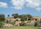
TheCaptain visited on 25th Jul 2005 - their rating: Cond: 4 Amb: 4 Access: 4 High up in the hills to the northwest of St-Nectaire can be found this dolmen, still almost entirely contained within its cairn of stones. The capstone is visible above a chamber, just above the top level of the present day cairn, and is about 4 metres by 3 metres. Apart from one squared corner, and the upper most row of side support stones, not much can be seen at all of the chamber below, which may have been quite large. The stone cairn is approximately 20 metres in diameter, and still about 2.5 to 3 metres high.
The dolmen is fairly easily found by taking a trackway south from the D.640 road along the hilltop above St-Nectaire near Sailles, and is the same trackway which leads to the easily visible Freydefrond menhir. But where a right turn leads to the menhir, take a left turn along a track into the woods, and after a couple of hundred metres the cairn becomes obvious, right at the end of the track.
johnstone visited on 13th Jul 1999 - their rating: Cond: 4 Amb: 4 Access: 4
Average ratings for this site from all visit loggers: Condition: 4 Ambience: 4 Access: 4
")
Apart from one squared corner, and the upper most row of side support stones, not much can be seen at all of the chamber below, which may have been quite large. The stone cairn is approximately 20 metres in diameter, and still about 2.5 to 3 metres high.
The dolmen is fairly easily found by taking a trackway south from the D.640 road along the hilltop above St-Nectaire near Sailles, and is the same trackway which leads to the easily visible Freydefrond menhir. But where a right turn leads to the menhir, take a left turn along a track into the woods, and after a couple of hundred metres the cairn becomes obvious, right at the end of the track.
Base Mérimée (Historic Monument)
You may be viewing yesterday's version of this page. To see the most up to date information please register for a free account.
")
")
")
")
")
")
")
")
")
Do not use the above information on other web sites or publications without permission of the contributor.
Click here to see more info for this site
Nearby sites
Click here to view sites on an interactive map of the areaKey: Red: member's photo, Blue: 3rd party photo, Yellow: other image, Green: no photo - please go there and take one, Grey: site destroyed
Download sites to:
KML (Google Earth)
GPX (GPS waypoints)
CSV (Garmin/Navman)
CSV (Excel)
To unlock full downloads you need to sign up as a Contributory Member. Otherwise downloads are limited to 50 sites.
Turn off the page maps and other distractions
Nearby sites listing. In the following links * = Image available
434m WNW 289° Freydefond Menhir* Standing Stone (Menhir)
567m SSE 169° Grottes de Châteauneuf* Cave or Rock Shelter
717m ENE 67° Plateau de Sailles tumulus* Barrow Cemetery
1.3km SSW 196° Saint Roch Menhir* Standing Stone (Menhir)
2.0km SSE 153° Dolmen du Parc (Saint-Nectaire)* Burial Chamber or Dolmen
2.1km SSW 198° Sapchat menhir* Standing Stone (Menhir)
2.2km SSW 199° Dolmen de Sapchat 2* Burial Chamber or Dolmen
2.2km SSW 199° Dolmen de Sapchat* Burial Chamber or Dolmen
3.1km SW 228° Autel des Druides (Murol) Burial Chamber or Dolmen
4.1km S 190° La Roche Romaine de Saint-Victor-la-Rivière* Natural Stone / Erratic / Other Natural Feature
4.2km SE 137° Saillant Dolmen* Burial Chamber or Dolmen
5.6km N 5° Pierre Longue (Fohet)* Standing Stone (Menhir)
5.9km NE 43° Pierre Branlante de Cournols Natural Stone / Erratic / Other Natural Feature
5.9km NE 43° Les Pierres Longues de Cournols* Natural Stone / Erratic / Other Natural Feature
6.3km S 173° Grottes de Jonas* Cave or Rock Shelter
6.4km NE 41° Cournols allée couverte* Passage Grave
6.6km S 169° Dolmen du Lac (Le Cheix)* Burial Chamber or Dolmen
6.6km ENE 64° Olloix Dolmen* Burial Chamber or Dolmen
6.6km ENE 64° Pierre Branlante d'Olloix* Natural Stone / Erratic / Other Natural Feature
8.5km E 99° Montaigut-Le-Blanc menhir Standing Stone (Menhir)
8.6km E 99° La Chabanette Burial Chamber or Dolmen
10.8km E 89° Menhir dit Pierre Fichade* Standing Stone (Menhir)
10.9km N 354° Grotte de Ribbe-Haute Cave or Rock Shelter
11.1km ESE 119° Site archeologique du Chastel* Ancient Village or Settlement
12.1km NNE 28° Chaos de Flore* Rock Outcrop
View more nearby sites and additional images


 We would like to know more about this location. Please feel free to add a brief description and any relevant information in your own language.
 Wir möchten mehr über diese Stätte erfahren. Bitte zögern Sie nicht, eine kurze Beschreibung und relevante Informationen in Deutsch hinzuzufügen.
 Nous aimerions en savoir encore un peu sur les lieux. S'il vous plaît n'hesitez pas à ajouter une courte description et tous les renseignements pertinents dans votre propre langue.
 Quisieramos informarnos un poco más de las lugares. No dude en añadir una breve descripción y otros datos relevantes en su propio idioma.