


<< Other Photo Pages >> Cupules du Rocher du Géant - Rock Art in France in Alsace-Lorraine:Haut-Rhin (68)
Submitted by AlexHunger on Saturday, 16 April 2005 Page Views: 3527
Rock ArtSite Name: Cupules du Rocher du Géant Alternative Name: Rocher du GeantCountry: France Département: Alsace-Lorraine:Haut-Rhin (68) Type: Rock Art
Nearest Town: Colmar Nearest Village: Thannenkirch
Latitude: 48.237460N Longitude: 7.278310E
Condition:
| 5 | Perfect |
| 4 | Almost Perfect |
| 3 | Reasonable but with some damage |
| 2 | Ruined but still recognisable as an ancient site |
| 1 | Pretty much destroyed, possibly visible as crop marks |
| 0 | No data. |
| -1 | Completely destroyed |
| 5 | Superb |
| 4 | Good |
| 3 | Ordinary |
| 2 | Not Good |
| 1 | Awful |
| 0 | No data. |
| 5 | Can be driven to, probably with disabled access |
| 4 | Short walk on a footpath |
| 3 | Requiring a bit more of a walk |
| 2 | A long walk |
| 1 | In the middle of nowhere, a nightmare to find |
| 0 | No data. |
| 5 | co-ordinates taken by GPS or official recorded co-ordinates |
| 4 | co-ordinates scaled from a detailed map |
| 3 | co-ordinates scaled from a bad map |
| 2 | co-ordinates of the nearest village |
| 1 | co-ordinates of the nearest town |
| 0 | no data |
Internal Links:
External Links:
")
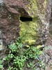
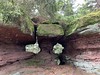
Cup holes in natural rock
A lot of Pictures:
Taennchel by oliv67
You may be viewing yesterday's version of this page. To see the most up to date information please register for a free account.
")
")
")
Do not use the above information on other web sites or publications without permission of the contributor.
Nearby Images from Flickr


The above images may not be of the site on this page, but were taken nearby. They are loaded from Flickr so please click on them for image credits.
Click here to see more info for this site
Nearby sites
Click here to view sites on an interactive map of the areaKey: Red: member's photo, Blue: 3rd party photo, Yellow: other image, Green: no photo - please go there and take one, Grey: site destroyed
Download sites to:
KML (Google Earth)
GPX (GPS waypoints)
CSV (Garmin/Navman)
CSV (Excel)
To unlock full downloads you need to sign up as a Contributory Member. Otherwise downloads are limited to 50 sites.
Turn off the page maps and other distractions
Nearby sites listing. In the following links * = Image available
43m SW 229° Rocher des Cordonniers* Rock Outcrop
490m W 275° Rocher de la Petite Fée* Rock Outcrop
627m W 271° Rocher des Reptiles* Rock Outcrop
1.1km W 262° Roches des Trois Tables* Rock Outcrop
1.1km W 261° Rocher de l'Anneau* Rock Outcrop
1.2km SSE 160° Taenchel Menhirs Couche Standing Stone (Menhir)
1.3km SSE 162° La Roche Pointue* Rock Outcrop
1.5km SSE 155° Mur Païen* Promontory Fort / Cliff Castle
1.9km SSE 152° Roche de la Garde* Rock Outcrop
2.2km SSE 154° Rocher de la Paix d'Udine* Rock Outcrop
5.1km N 9° Cupules du Mont Chaumont Rock Art
6.9km NNE 21° Rocher du Coucou Rock Art
7.3km NNE 28° Enceinte de Frankenbourg* Ancient Village or Settlement
7.4km N 7° Roches des Fées (Neubois) Natural Stone / Erratic / Other Natural Feature
12.8km NE 52° Rochers des Celtes* Barrow Cemetery
13.9km NE 46° Dambach-la-Ville Menhir* Modern Stone Circle etc
15.3km NE 55° Pierre de la Chapelle Saint-Jean* Standing Stone (Menhir)
16.7km E 90° Nachtweide Tumuli* Artificial Mound
16.7km E 90° Mussig Tumuli* Artificial Mound
16.8km ESE 112° Hoelmatt Tumulus* Artificial Mound
17.9km N 357° Menhir dit le Rocher des Poupons Standing Stone (Menhir)
20.4km S 183° La Fontaine de la Dame* Holy Well or Sacred Spring
20.9km S 183° Rocher Turenne* Natural Stone / Erratic / Other Natural Feature
21.3km S 171° Ricoh Tumuli* Artificial Mound
22.8km NNE 24° Rocher Robert Forrer* Ancient Mine, Quarry or other Industry
View more nearby sites and additional images


 We would like to know more about this location. Please feel free to add a brief description and any relevant information in your own language.
 Wir möchten mehr über diese Stätte erfahren. Bitte zögern Sie nicht, eine kurze Beschreibung und relevante Informationen in Deutsch hinzuzufügen.
 Nous aimerions en savoir encore un peu sur les lieux. S'il vous plaît n'hesitez pas à ajouter une courte description et tous les renseignements pertinents dans votre propre langue.
 Quisieramos informarnos un poco más de las lugares. No dude en añadir una breve descripción y otros datos relevantes en su propio idioma.