

<< Our Photo Pages >> Faughan - Standing Stones in England in Cornwall
Submitted by vicky on Monday, 26 April 2004 Page Views: 9326
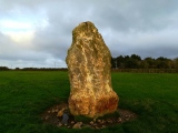
Neolithic and Bronze AgeSite Name: FaughanCountry: England County: Cornwall Type: Standing Stones
Map Ref: SW45222822 Landranger Map Number: 203
Latitude: 50.099305N Longitude: 5.564038W
Condition:
| 5 | Perfect |
| 4 | Almost Perfect |
| 3 | Reasonable but with some damage |
| 2 | Ruined but still recognisable as an ancient site |
| 1 | Pretty much destroyed, possibly visible as crop marks |
| 0 | No data. |
| -1 | Completely destroyed |
| 5 | Superb |
| 4 | Good |
| 3 | Ordinary |
| 2 | Not Good |
| 1 | Awful |
| 0 | No data. |
| 5 | Can be driven to, probably with disabled access |
| 4 | Short walk on a footpath |
| 3 | Requiring a bit more of a walk |
| 2 | A long walk |
| 1 | In the middle of nowhere, a nightmare to find |
| 0 | No data. |
| 5 | co-ordinates taken by GPS or official recorded co-ordinates |
| 4 | co-ordinates scaled from a detailed map |
| 3 | co-ordinates scaled from a bad map |
| 2 | co-ordinates of the nearest village |
| 1 | co-ordinates of the nearest town |
| 0 | no data |
Internal Links:
External Links:
I have visited· I would like to visit
celticmaiden55 would like to visit
lucasn visited on 18th Aug 2020 - their rating: Cond: 4 Amb: 3 Access: 3
Bladup cazzyjane have visited here
")
The stones were possibly reused as gateposts at the entrance to the hillfort.
You may be viewing yesterday's version of this page. To see the most up to date information please register for a free account.
")
")
")
")
")
")
")
")
")
")
")
")
")
")
")
")
")
")
")
")
")
")
")
")
These are just the first 25 photos of Faughan. If you log in with a free user account you will be able to see our entire collection.
Do not use the above information on other web sites or publications without permission of the contributor.
Click here to see more info for this site
Nearby sites
Key: Red: member's photo, Blue: 3rd party photo, Yellow: other image, Green: no photo - please go there and take one, Grey: site destroyed
Download sites to:
KML (Google Earth)
GPX (GPS waypoints)
CSV (Garmin/Navman)
CSV (Excel)
To unlock full downloads you need to sign up as a Contributory Member. Otherwise downloads are limited to 50 sites.
Turn off the page maps and other distractions
Nearby sites listing. In the following links * = Image available
220m W 262° Chyenhal Settlement Ancient Village or Settlement (SW450282)
568m W 266° Ennis Farm Standing Stone* Standing Stone (Menhir) (SW44652821)
656m WSW 248° Tresvennack Tumulus* Round Barrow(s) (SW446280)
727m S 190° Chyenhal* Standing Stone (Menhir) (SW45062751)
954m NW 317° Buryas Bridge menhir* Standing Stone (Menhir) (SW4459928947)
969m W 263° Tresvennack 2* Standing Stone (Menhir) (SW44252815)
988m SE 134° Sheffield* Standing Stone (Menhir) (SW459275)
991m NNW 338° Trembath Cross* Ancient Cross (SW4489229156)
1.1km WSW 249° Tresvennack Pillar* Standing Stone (Menhir) (SW44182787)
1.2km SW 223° Kerris* Standing Stone (Menhir) (SW44392742)
1.3km NE 44° Trereife Cross* Ancient Cross (SW4614229077)
1.3km SSW 210° Kerris Settlement* Ancient Village or Settlement (SW445271)
1.4km SW 217° Kerris Crosses* Ancient Cross (SW44332716)
1.4km N 358° Paul Downs Cross* Ancient Cross (SW45252963)
1.5km W 271° Drift Stones* Standing Stones (SW43712831)
1.6km NNE 32° Tolcarne (Mount Misery) Round Ancient Village or Settlement (SW461295)
1.6km WNW 287° Lower Drift Cross* Ancient Cross (SW43752875)
1.6km SSW 192° Redhouse* Standing Stones (SW44802663)
1.7km SE 129° Paul Churchyard* Ancient Cross (SW465271)
1.9km NW 316° Trewidden Round* Ancient Village or Settlement (SW43952967)
1.9km S 187° Trevello Stone Circle (SW449263)
2.0km NNW 346° Tremethick Cross* Ancient Cross (SW4483730144)
2.1km SSW 194° Trevelloe Carn* Rock Outcrop (SW446262)
2.2km N 1° Lesingey Round* Hillfort (SW45353037)
2.2km NNE 21° Castle Horneck Well* Holy Well or Sacred Spring (SW461302)
View more nearby sites and additional images


 We would like to know more about this location. Please feel free to add a brief description and any relevant information in your own language.
 Wir möchten mehr über diese Stätte erfahren. Bitte zögern Sie nicht, eine kurze Beschreibung und relevante Informationen in Deutsch hinzuzufügen.
 Nous aimerions en savoir encore un peu sur les lieux. S'il vous plaît n'hesitez pas à ajouter une courte description et tous les renseignements pertinents dans votre propre langue.
 Quisieramos informarnos un poco más de las lugares. No dude en añadir una breve descripción y otros datos relevantes en su propio idioma.