


<< Our Photo Pages >> Tinkinswood standing stones - Standing Stones in Wales in South Glamorgan
Submitted by TheCaptain on Saturday, 27 April 2024 Page Views: 38
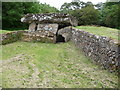
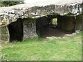
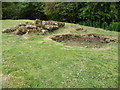
Neolithic and Bronze AgeSite Name: Tinkinswood standing stonesCountry: Wales County: South Glamorgan Type: Standing Stones
Nearest Village: St Nicholas
Map Ref: ST09247327
Latitude: 51.451114N Longitude: 3.307521W
Condition:
| 5 | Perfect |
| 4 | Almost Perfect |
| 3 | Reasonable but with some damage |
| 2 | Ruined but still recognisable as an ancient site |
| 1 | Pretty much destroyed, possibly visible as crop marks |
| 0 | No data. |
| -1 | Completely destroyed |
| 5 | Superb |
| 4 | Good |
| 3 | Ordinary |
| 2 | Not Good |
| 1 | Awful |
| 0 | No data. |
| 5 | Can be driven to, probably with disabled access |
| 4 | Short walk on a footpath |
| 3 | Requiring a bit more of a walk |
| 2 | A long walk |
| 1 | In the middle of nowhere, a nightmare to find |
| 0 | No data. |
| 5 | co-ordinates taken by GPS or official recorded co-ordinates |
| 4 | co-ordinates scaled from a detailed map |
| 3 | co-ordinates scaled from a bad map |
| 2 | co-ordinates of the nearest village |
| 1 | co-ordinates of the nearest town |
| 0 | no data |
Internal Links:
External Links:
")
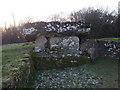
These look fairly ancient. Is it possible that they some ancient stone remains, or are they simple the remains of an old stile? They are marked on the large scale OS maps.
You may be viewing yesterday's version of this page. To see the most up to date information please register for a free account.
")
")
Do not use the above information on other web sites or publications without permission of the contributor.
Nearby Images from Geograph Britain and Ireland:
©2011(licence)
©2011(licence)
©2011(licence)
©2018(licence)
©2011(licence)
The above images may not be of the site on this page, they are loaded from Geograph.
Please Submit an Image of this site or go out and take one for us!
Click here to see more info for this site
Nearby sites
Key: Red: member's photo, Blue: 3rd party photo, Yellow: other image, Green: no photo - please go there and take one, Grey: site destroyed
Download sites to:
KML (Google Earth)
GPX (GPS waypoints)
CSV (Garmin/Navman)
CSV (Excel)
To unlock full downloads you need to sign up as a Contributory Member. Otherwise downloads are limited to 50 sites.
Turn off the page maps and other distractions
Nearby sites listing. In the following links * = Image available
42m NW 314° Tinkinswood* Chambered Cairn (ST09217330)
45m SSE 152° Tinkinswood avenue* Stone Row / Alignment (ST09267323)
90m E 89° Tinkinswood 2* Burial Chamber or Dolmen (ST09337327)
98m ENE 65° Tinkinswood quarry* Ancient Mine, Quarry or other Industry (ST09337331)
114m NE 51° Tinkinswood outliers* Rock Outcrop (ST09337334)
1.2km WNW 293° Coed-Y-Cwm* Chambered Cairn (ST08117378)
1.3km SE 138° St Lythans* Chambered Tomb (ST10097230)
1.5km NW 305° Cottrell Park Standing Stone* Standing Stone (Menhir) (ST0804574124)
1.5km ENE 74° St Lythans Down Round Barrow* Round Barrow(s) (ST10717367)
1.5km WNW 290° Redland Farm Standing Stone (Menhir) (ST07817382)
1.6km NNW 348° St Nicholas' Well (Glamorgan)* Holy Well or Sacred Spring (ST08937484)
1.6km ENE 62° Vianshill Round Barrow(s) (ST10717401)
2.0km E 82° Marsyd Round Barrow(s) (ST11217352)
2.1km SE 129° Goldsland Wood Cave Cave or Rock Shelter (ST109719)
2.3km E 81° Quarrymen Stone* Modern Stone Circle etc (ST115736)
3.9km NW 311° Ffynnon Deilo* Holy Well or Sacred Spring (ST0633975904)
4.1km E 79° Coed-y Cymdda Hillfort (ST13297398)
4.5km ENE 66° Caerau (Cardiff)* Hillfort (ST13377498)
4.5km SE 133° Pencoetre Wood Barrow Round Barrow(s) (ST125701)
4.6km NNE 31° Museum of Welsh Life, St Fagans* Museum (ST117772)
4.6km E 89° Cwrt-yr-ala Hillfort (ST139733)
4.7km NNE 34° St Fagan's Well Holy Well or Sacred Spring (ST11917712)
4.7km SW 224° Castle Ditches Fort* Hillfort (ST059699)
5.1km N 8° Sant-Y-Nyll Round Barrow(s) (ST10077829)
5.7km SW 223° Pen Onn Farmstead Ancient Village or Settlement (ST053692)
View more nearby sites and additional images


 We would like to know more about this location. Please feel free to add a brief description and any relevant information in your own language.
 Wir möchten mehr über diese Stätte erfahren. Bitte zögern Sie nicht, eine kurze Beschreibung und relevante Informationen in Deutsch hinzuzufügen.
 Nous aimerions en savoir encore un peu sur les lieux. S'il vous plaît n'hesitez pas à ajouter une courte description et tous les renseignements pertinents dans votre propre langue.
 Quisieramos informarnos un poco más de las lugares. No dude en añadir una breve descripción y otros datos relevantes en su propio idioma.