<< Our Photo Pages >> Moel-y-Gaer (Flintshire) - Hillfort in Wales in Flintshire
Submitted by blingo on Friday, 04 September 2009 Page Views: 14600
Iron Age and Later PrehistorySite Name: Moel-y-Gaer (Flintshire) Alternative Name: Moel y GaerCountry: Wales County: Flintshire Type: Hillfort
Nearest Town: Northop Nearest Village: Rhosesmor
Map Ref: SJ21116904 Landranger Map Number: 117
Latitude: 53.212542N Longitude: 3.182782W
Condition:
| 5 | Perfect |
| 4 | Almost Perfect |
| 3 | Reasonable but with some damage |
| 2 | Ruined but still recognisable as an ancient site |
| 1 | Pretty much destroyed, possibly visible as crop marks |
| 0 | No data. |
| -1 | Completely destroyed |
| 5 | Superb |
| 4 | Good |
| 3 | Ordinary |
| 2 | Not Good |
| 1 | Awful |
| 0 | No data. |
| 5 | Can be driven to, probably with disabled access |
| 4 | Short walk on a footpath |
| 3 | Requiring a bit more of a walk |
| 2 | A long walk |
| 1 | In the middle of nowhere, a nightmare to find |
| 0 | No data. |
| 5 | co-ordinates taken by GPS or official recorded co-ordinates |
| 4 | co-ordinates scaled from a detailed map |
| 3 | co-ordinates scaled from a bad map |
| 2 | co-ordinates of the nearest village |
| 1 | co-ordinates of the nearest town |
| 0 | no data |
Internal Links:
External Links:
I have visited· I would like to visit
SolarMegalith would like to visit
 (PID:30840)")
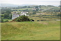
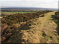
Located on Halkyn Mountain, the Iron Age hillfort occupies an isolated grassy hill, with a commanding outlook. There are fine views to the west along the chain of hillforts on the Clwydian Range, and east and south across the Dee Estuary to the Wirral and Lancashire.
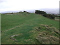
Moel y Gaer is important because of the results of excavations in the 1970s. Within the fort different phases of roundhouse construction were found, including a period when a rectangular building was constructed. As well as traces of roundhouses, three small 'four-posters' were detected. They were probably storehouses or granaries kept off the ground to protect food from vermin.
Acidic soil conditions meant that few objects were preserved but heaps of water-worn pebbles were found against one of the earlier phases of ramparts. These are believed to have been caches of slingstones, possible evidence of warfare and raiding. The prominent inner rampart includes an inturned entrance on the south-east side and the site was defended by ditches as well as a low bank 10m outside the main ditch on the south and west.
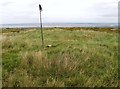
None of the roundhouses or other buildings are now visible - and don't be confused by the reservoir. A triangulation pillar has been positioned on top of a Bronze Age round barrow.
Note: Hill fort dates back 3,000 years, see latest comment
You may be viewing yesterday's version of this page. To see the most up to date information please register for a free account.
 (PID:78787)")
Do not use the above information on other web sites or publications without permission of the contributor.
Nearby Images from Geograph Britain and Ireland:

©2021(licence)
©2010(licence)
©2013(licence)
©2007(licence)
©2023(licence)
The above images may not be of the site on this page, they are loaded from Geograph.
Please Submit an Image of this site or go out and take one for us!
Click here to see more info for this site
Nearby sites
Key: Red: member's photo, Blue: 3rd party photo, Yellow: other image, Green: no photo - please go there and take one, Grey: site destroyed
Download sites to:
KML (Google Earth)
GPX (GPS waypoints)
CSV (Garmin/Navman)
CSV (Excel)
To unlock full downloads you need to sign up as a Contributory Member. Otherwise downloads are limited to 50 sites.
Turn off the page maps and other distractions
Nearby sites listing. In the following links * = Image available
61m N 350° Moel-y-Gaer Circle Timber Circle (SJ211691)
1.8km WSW 248° Hendre Farm Round Barrow(s) (SJ19426838)
2.8km WSW 240° Ffynnon Leinw Holy Well or Sacred Spring (SJ18636767)
2.8km WSW 258° Pen-Y-Gelli* Round Barrow(s) (SJ18316851)
4.1km WSW 253° Penbedw Park* Stone Circle (SJ17126793)
4.2km NW 320° Parc y Prysau 2 Round Barrow(s) (SJ185723)
4.2km WSW 257° Penbedw Park Tumulus* Round Barrow(s) (SJ17006819)
4.3km SSE 160° Rhual Isaf* Round Barrow(s) (SJ22546496)
4.5km NW 320° Parc y Prysau 1* Round Barrow(s) (SJ183725)
4.5km WSW 253° Penbedw Park Standing Stone* Standing Stone (Menhir) (SJ168678)
4.5km SSE 164° Goblins Well Holy Well or Sacred Spring (SJ22256469)
4.9km NW 313° Llwyn Erddyn* Ring Cairn (SJ17567249)
5.1km NW 312° Plas Captain* Cairn (SJ17367253)
5.2km SSE 152° Mold Gorsedd Circle Modern Stone Circle etc (SJ2352364421)
5.4km SSE 151° Standing Stone St Mary's Church* Standing Stone (Menhir) (SJ2363864213)
5.6km NE 34° Stone Circle, Flint Industrial Estate (Modern)* Modern Stone Circle etc (SJ2432473575)
5.7km NE 34° Stone Circles, Flint Country Park (Modern)* Modern Stone Circle etc (SJ2441773744)
5.7km SSE 152° Mold Library and Museum* Museum (SJ237639)
6.0km SSE 147° Bryn-yr-Ellyllon* Round Barrow(s) (SJ2434063930)
6.5km S 187° Carreg Carn March Arthur Marker Stone (SJ202626)
6.7km NW 325° Brynford* Barrow Cemetery (SJ174746)
6.8km NW 313° Gatehouse Farm Round Barrow(s) (SJ162737)
7.0km N 5° Bagillt Stonehenge (Modern)* Modern Stone Circle etc (SJ2179576045)
7.0km N 5° Bagillt 'Stonehenge' Modern Stone Circle etc (SJ21807605)
7.2km NW 305° Waen Isaf Round Barrow(s) (SJ153733)
View more nearby sites and additional images


 We would like to know more about this location. Please feel free to add a brief description and any relevant information in your own language.
 Wir möchten mehr über diese Stätte erfahren. Bitte zögern Sie nicht, eine kurze Beschreibung und relevante Informationen in Deutsch hinzuzufügen.
 Nous aimerions en savoir encore un peu sur les lieux. S'il vous plaît n'hesitez pas à ajouter une courte description et tous les renseignements pertinents dans votre propre langue.
 Quisieramos informarnos un poco más de las lugares. No dude en añadir una breve descripción y otros datos relevantes en su propio idioma.